Quick-hitting round of snow to blanket New England on Friday
The best chance of accumulating snow is likely north and west of Interstate 95 in Connecticut, Rhode Island, Massachusetts, southern Vermont, New Hampshire and Maine.

Quick-hitting round of snow to blanket New England on Friday
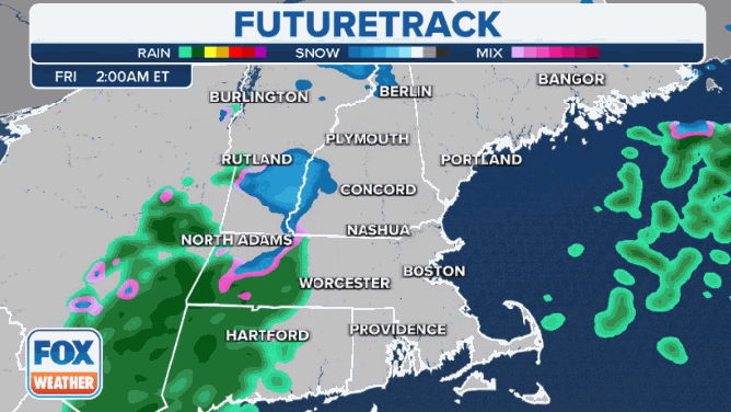
A fast-moving disturbance sliding just off the New England coast will produce a quick burst of snow across New England on Friday. The best chance of accumulating snow looks to be north and east of I-95 in Massachusetts, Rhode Island and Connecticut.
A fast-moving disturbance sliding just off the New England coast will produce a quick burst of snow across the region Friday.
The best chance of accumulating snow is likely north and west of Interstate 95 in Connecticut, Rhode Island, Massachusetts, southern Vermont, New Hampshire and Maine. According to the FOX Forecast Center, the snow will quickly pick up in intensity, and untreated roads are expected to become snow-covered.
Snow will continue through Friday afternoon before winding down during the evening as the disturbance pushes off to the east.
A fast-moving disturbance sliding just off the New England coast will produce a quick burst of snow across the region Friday.
(FOX Weather)
"We do have a Winter Weather Advisory in place for most of Massachusetts … the possibility that we could see some slick conditions, especially at times where that snow rate could come down, reduce visibility, where we are going to pick up a couple inches by the end of the day," FOX Weather meteorologist Jane Minar said.
DRIVING IN LIGHT SNOW IS JUST AS DANGEROUS AS A MAJOR SNOWSTORM, RESEARCHERS SAY
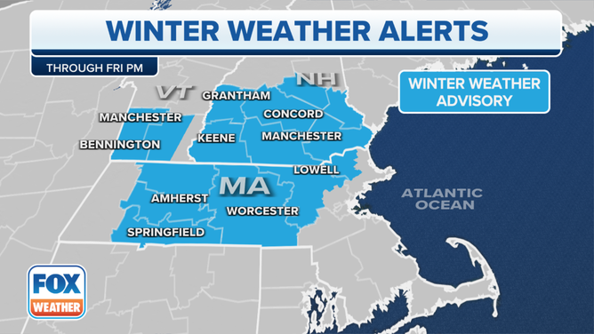
Here's a look at the winter weather alerts issued in the Northeast through Friday evening.
(FOX Weather)
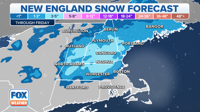
As much as 2 to 5 inches of snow is expected in these areas, with the 5-inch amounts most likely in the Worcester Hills of central Massachusetts, the Berkshires of western Massachusetts and southern Vermont, as well as southern New Hampshire.
Between 1 and 2 inches of snow is likely in portions of Maine and in the Litchfield Hills of northwestern Connecticut.
THESE ARE THE 7 SNOWIEST CITIES IN THE US
The best chance of accumulating snow is likely north and west of Interstate 95 in Connecticut, Rhode Island, Massachusetts, southern Vermont, New Hampshire and Maine.
(FOX Weather)
For eastern Massachusetts (including Boston), Rhode Island (including Providence) and the Connecticut River Valley (including Hartford), the forecast remains highly uncertain whether it stays rain or changes over to snow, the FOX Forecast Center said.
Even if the precipitation changes over to light snow in those areas, road temperatures above freezing will likely prevent much in the way of accumulation. However, heavier snow would overcome the relative warmth, which could result in a coating to an inch of snow in some spots.
WINTER IS HERE AND MY KIDS INSIST ON WEARING SHORTS. IS IT OK?
Snow will continu<strong>e</strong> through Friday afternoon before winding down during the evening as the disturbance pushes off to the east.
(FOX Weather)
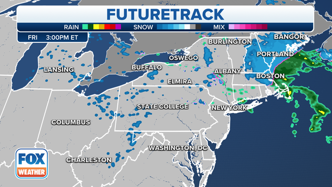
Back to the west, scattered snow showers are expected as an upper-level low-pressure system continues to spin across the Great Lakes. This includes cities such as Detroit, Cleveland, Columbus in Ohio, Pittsburgh and Buffalo in New York.
The snow showers will transition into weak lake-effect snow downwind of lakes Erie and Ontario in western and central New York and northwestern Pennsylvania on Saturday. An inch or two is possible in the most persistent snows, although most places will see lower amounts.
"Everything kind of tapers off overnight, and we begin the weekend on a much drier and clearer note and maybe a few lake-effect snow showers just because of that wind direction coming off of Lake Erie," Minar said. "But we are anticipating not too much more in the forecast as far as snow potential."