Powerful 'bomb cyclone' brings mountain blizzards, power outages to Pacific Northwest
Over 100,000 people lost power across western Washington and Oregon during the peak of the storm early Tuesday morning as wind gusts reached 40-60 mph as blizzard conditions raked the Cascades and Olympics.
Pacific Northwest pummeled by late week flood, snow threat for East
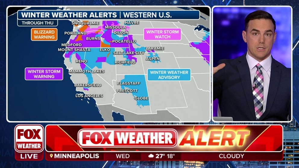
Blizzard Warnings are in effect through Thursday morning for high elevations of Washington, Oregon and Idaho. Feet of snow have fallen already with winds gusting to 55 mph. The storm sinks into California and Nevada for Wednesday.
SEATTLE – A powerful "bomb cyclone" is blasting the Pacific Northwest, knocking out power with ferocious winds and bringing rare blizzard conditions to the Cascades and Olympics.
Over 100,000 people lost power across western Washington and Oregon during the peak of the storm early Tuesday morning as wind gusts reached 40-60 mph.
Blizzard Warnings remain in place through Wednesday morning for winds gusting to 55 mph and an additional 8-16 inches of snow.
Heavy snow combined with strong winds make pass travel difficult to impossible above 2,000 feet in the Cascades and Olympics.
(FOX Weather)
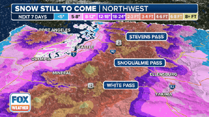
As much as 2-3 feet of new snow fell Tuesday, with wind gusts racing as high as 60 mph making for whiteout conditions. It was the first Blizzard Warning issued by the Seattle office of the National Weather Service in over 11 years. The southern Oregon Cascades could see as much as 45 inches of total snow.
WHAT MAKES A BLIZZARD DIFFERENT THAN AN ORDINARY SNOWSTORM?

(FOX Weather)
For the rest of the Inland Northwest, widespread Winter Storm Warnings cover much of Idaho and eastern Oregon for up to 6 inches of snow in the lower elevations and up to 2 feet in the higher elevations.
And the storm's effects will eventually reach south into California, where Winter Storm Warnings are posted in the Siskiyous and Sierra Nevada for Wednesday into early Thursday for again gusty winds combining with several inches of snow. Wind gusts along the peaks of the Sierra could reach 80-100 mph, while snow totals will reach 1-3 feet in the higher elevations.
7 WAYS TO STAY SAFE WHILE USING A GENERATOR
The term "bomb cyclone" comes from the meteorological term "bombogenesis" or "explosive cyclogenesis." This happens when a storm system's central pressure drops at least 24 millibars within 24 hours. Surface analysis showed this storm dropped 29 millibars in 24 hours before making landfall on Vancouver Island.
More winter storms loom
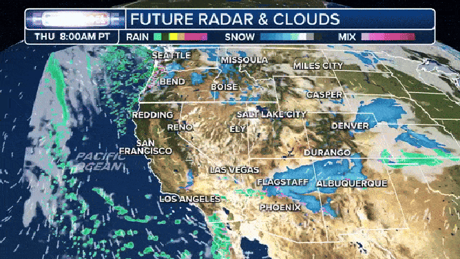
While there may be a brief break in the weather Wednesday, another round of wintry weather is forecast for Thursday into the weekend across the Pacific Northwest.
HOW TO DRIVE IN ICY CONDITIONS
(FOX Weather)
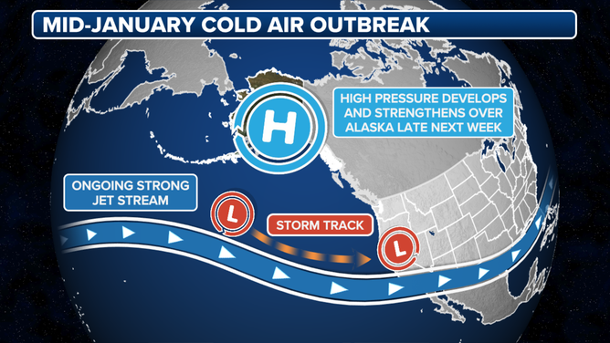
An arctic air mass dropping out of Canada is expected to bring the coldest temperatures of the winter so far, along with another threat of wintry precipitation.
The next major storm arrives Friday into Saturday.
The next impressive storm hits Friday and Saturday.
(FOX Weather)