Life-threatening flooding threatens multiple states as hurricane season's first tropical threat brews in Gulf
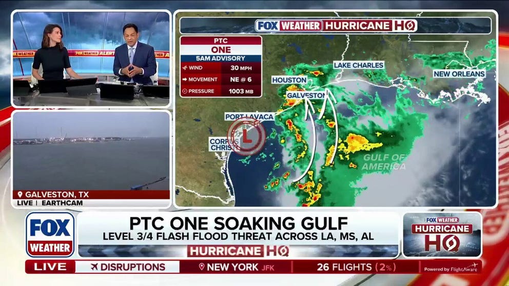
Potential Tropical Cyclone One is unleashing strong wind gusts along the Texas and Louisiana coasts, bringing heavy rain and life-threatening flash flooding that has caused a death in Montgomery County.
Potential Tropical Cyclone One fuels life-threatening floods as tropical storm development looms
Life-threatening flooding continues to batter the Gulf Coast as Potential Tropical Cyclone One’s chances of development loom. Tragically, one drowning death has been confirmed in Texas, and tropical storm alerts remain in effect across parts of the Louisiana coast. Latest:
Editor's Note: At 11:00 AM E.T. on Wednesday, the National Hurricane Center designated Potential Tropical Cyclone One as Tropical Storm Arthur in the Gulf of America. Continuous coverage on Tropical Storm Arthur has moved here.
Tropical storm alerts continue for the Texas and Louisiana coastlines as the threat of Tropical Storm Arthur looms along the Gulf Coast.
Potential Tropical Cyclone (PTC) One is unleashing strong wind gusts along the Texas and Louisiana coasts, bringing heavy rain and life-threatening flash flooding that has caused a death in Montgomery County.
15-YEAR-OLD DROWNS IN FLOODED TEXAS POND AS POTENTIAL TROPICAL CYCLONE ONE LOOMS OVER GULF

(FOX Weather)
While the system has not yet developed, it is now teetering along the Texas coast and the Gulf, trying to emerge further over open waters.
There have already been wind gusts over 40 mph along the Texas coastline as of Wednesday morning, but there is no well-defined circulation to warrant an upgrade, the FOX Forecast said.
The National Hurricane Center (NHC) warned that extremely heavy rainfall and dangerous flash flooding are expected today.
WATCH: HEAVY RAIN TRIGGERS DANGEROUS FLASH FLOODING ACROSS TEXAS, PROMPTING MULTIPLE WATER RESCUES
The NCH designated the former Invest 90L, as Potential Tropical Cyclone (PTC) One on Monday, allowing them to issue Tropical Storm Watches and Warnings as the system targets the Gulf Coast.
Following the activation of these public advisories, ongoing Tropical Storm Warnings remain in effect from Sabine Pass to Morgan City, Louisiana.
Tropical Storm Watches also remain in effect from Sargent to Sabine Pass.
A PTC is typically designated when a storm hasn't yet formed, but there is the expectation that it will or produce at least tropical storm conditions within 72 hours, the FOX Forecast Center said.

(FOX Weather)
That said, environmental conditions are expected to be marginally conducive for the formation of a short-lived tropical storm.
With water temperatures in the mid-80s and large-scale lift, the environment favors development. However, moderate wind shear and limited time over open water will be the deciding factors that ultimately restrict how strong PTC One can become.
There is nothing to indicate PTC One will become a strong storm, and it may never be a tropical depression or storm, the FOX Forecast Center said.
But, if it does, the first name on the list is Arthur.

(FOX Weather)
Regardless of how strong the system gets, a significant flash flood threat is expected to continue along the Gulf Coast through late week.
The NHC forecasts 5 to 10 inches of rain through early Friday, with isolated totals near 20 inches.

(FOX Weather)
With that, Flood Watches are in effect across Texas, much of Louisiana, Mississippi and up through Alabama and Georgia, including major cities such as New Orleans, Montgomery and Atlanta through Friday.
Additionally, wind speeds will heavily depend on the final strength of the system.
Based on the latest data, the FOX Forecast Center said the most intense gusts are expected along the immediate coast, stretching from roughly Galveston Bay in Texas over toward central Louisiana in Vermillion Bat.

(FOX Weather)
Wind gusts over 40 mph could trigger minor coastal flooding, with the strongest winds peaking on Wednesday before the system pushes inland Wednesday night into early Thursday.
Along with that, strong southerly winds will continue pushing into the Gulf Coast, which will keep coastal water levels up.