Pacific Northwest faces potential threat of snow, ice as winter storm looms for weekend
In an unusual and prolonged standoff, some computer forecast models have stubbornly suggested the weekend worries are much ado about nothing, leaving potential outcomes ranging from a major winter storm to a relatively dry and chilly weekend.
Northwest recovering from blizzard and prepping for the next storm over the weekend
The Pacific Northwest and California are still reeling from blizzard conditions and heavy snow from the last storm. Now first responders have to prep for the next major winter storm arriving over the weekend.
PORTLAND, Ore. – A very tricky forecast has much of the Pacific Northwest on edge for dealing with a potential winter storm from Friday into the weekend, including heavy snow, freezing rain and temperatures well below average.
But not all computer forecast models are sold on the idea – "like night and day," National Weather Service forecasters in Seattle said. And in an unusual and prolonged standoff, some models have stubbornly suggested the weekend worries are much ado about nothing, leaving potential outcomes ranging from a major winter storm to a relatively dry and chilly weekend.
At play is an intrusion of subfreezing air that is expected to push into the region on the fringes of a massive arctic blast rolling deep into America's Heartland later this week, courtesy of the polar vortex. Temperatures are expected to plunge well below zero in Montana.
This while Oregon and Washington are still cleaning up from days of blizzard conditions. California's Lake Tahoe region saw just under a foot-and-a-half of new snow over the past day. That contributed to an avalanche that killed one and injured another skier.
ONE PERSON DEAD AFTER AVALANCHE AT PALISADES TAHOE DURING CRIPPLING WINTER STORM
Some uncertainty remains over how much cold air will make it to the Pacific Northwest, especially into the heavily populated Interstate 5 corridor, where the cold air must get over or through gaps in the Cascade Mountain barrier. For example, one forecast model run gives a potential spread of high temperatures in Portland, Oregon, on Saturday between 19 and 42 degrees, according to the National Weather Service office in Portland. But most calculations agree enough cold air will make it into the region to bring subfreezing temperatures.

(FOX Weather)
The second factor is an incoming area of low pressure coming in off the Pacific Ocean from Friday into Saturday, carrying moisture to inject into the cold air. But there is an unusually large spread in model calculations on how that storm will behave.
Several model runs bring a rather robust storm right into the northern Oregon coast or along the Washington coast, spreading plenty of moisture into the frigid air for accumulating snowfall at sea level across the region, including the Seattle and Portland metro areas.
In addition, in these scenarios, milder air infused in the storm could bring a period of significant freezing rain accretions to northern Oregon – including the Portland area – and southwestern Washington, threatening power outages and additional travel woes.
![]() Image 1 of 2
Image 1 of 2Washington State troopers shared pictures of the accidents involving wind and trees flying through vehicles on Wednesday, Jan. 10, 2024. (Trooper Katherine Weatherwax via X)
![]() Image 2 of 2
Image 2 of 2Washington State troopers shared pictures of the accidents involving wind and trees flying through vehicles on Wednesday, Jan. 10, 2024. (Trooper Katherine Weatherwax via X)


European model: 'Not so fast…'
On the other hand, the vaunted European model has been steadfast that the incoming storm will be weaker and head farther south into Oregon, leaving much of Seattle and western Washington cool and relatively dry.
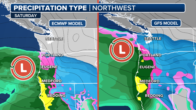
The ECMWF ("European") model prediction on Saturday for the Pacific Northwest vs. the American GFS model.
(FOX Weather)
These scenarios do still present a period of freezing rain accretions to northwestern Oregon between Portland and Eugene from Saturday into Sunday morning, keeping potentially impactful weather in the forecast there.
THE SOUND OF SILENCE: WHY IT’S QUIETER AFTER A SNOWSTORM

(FOX Weather)
"So for now, forecast confidence is far from high regarding how much lowland snow will fall and where exactly it will fall," National Weather Service forecasters in Seattle wrote. "But, confidence is increasing regarding the potential for a widespread modified arctic outbreak."
Forecast highs in western Washington for now show highs only in the 20s, with lows in the teens through the weekend.

(FOX Weather)
Winter Storm Watches in effect for parts of inland Northwest
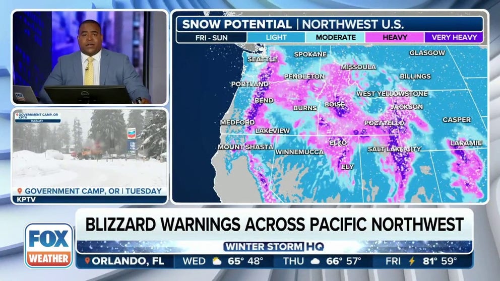
The uncertain snow forecast extends east of the Cascades as well. Although most solutions agree some accumulating snow will fall in eastern Oregon, the question is how much.
For eastern Washington and Idaho, again, it'll depend on storm track and strength, with potential snowfall ranging from little, if any, to multiple inches, especially closer to the Oregon border.

(FOX Weather)
Winter Storm Watches are posted for parts of northeastern Oregon and southeastern Washington to account for the heavier snowfall scenario.
But temperatures over the weekend will remain 20-30 degrees below average, with highs in the single digits or teens and lows in the single digits to perhaps even below zero.