Some Northeast, Midwest cities could see first 90-degree day as record heat looms late week
The lack of rain over the past few weeks across the Great Lakes and Upper Midwest is likely to lead to a flash drought, in which drought rapidly develops over a short period.
Dry conditions for Midwest, record heat possible for Northeast
Parts of the Midwest and Great Lakes region are starved for rain, as hot temperatures and dry conditions are bringing a flash drought to the Northeast and Midwest this week.
A stretch of very warm, dry days looms for the Northeast and Midwest this week as some cities could see temperature records broken as highs zoom into the 90s.
Temperatures will be 10 to 20 degrees above average as a ridge of high pressure spreads across the Northeast and Midwest, translating to highs mainly in the 80s over the next several days.
THESE ARE THE ALL-TIME HOTTEST TEMPERATURES EVER RECORDED IN EACH STATE
![Northern Tier Forecast Highs]() Image 1 of 3
Image 1 of 3A stretch of dry and warm days is coming to the northern tier this week as some cities could see their first 90-degree day.
![Northern Tier Forecast Highs]() Image 2 of 3
Image 2 of 3A stretch of dry and warm days is coming to the northern tier this week as some cities could see their first 90-degree day.
![Northern Tier Forecast Highs]() Image 3 of 3
Image 3 of 3A stretch of dry and warm days is coming to the northern tier this week as some cities could see their first 90-degree day.
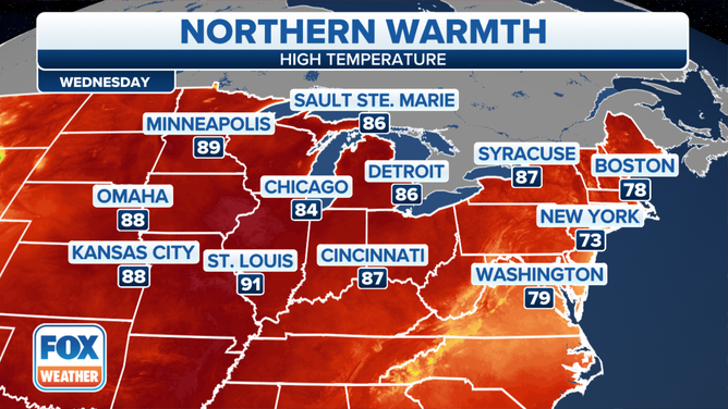
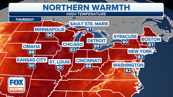
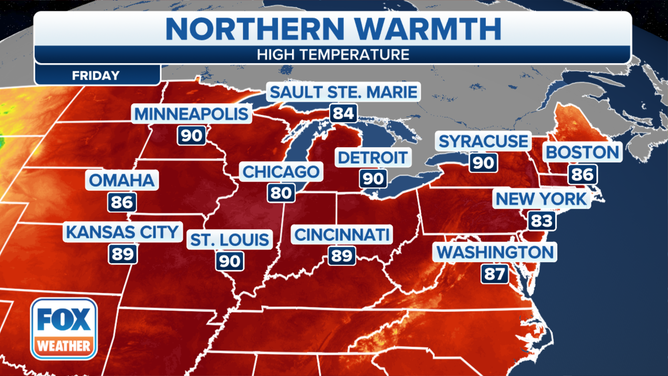
However, for a few spots, record highs could be threatened by Thursday and Friday as several cities make a run at 90 degrees for the first time this season.
Chicago O'Hare International Airport hit 90 degrees for the first time this year on Tuesday – nearly a week ahead of its average first 90-degree high temperature on June 5, according to the National Weather Service.
Burlington, Vermont, could reach the lower 90s Thursday afternoon, which would break its daily record high of 90 degrees set in 2013.

(FOX Weather)
Hartford, Connecticut, will then challenge its daily record high of 91 on Friday as it climbs into the lower to mid-90s.
WHEN TO EXPECT THE FIRST 90-DEGREE DAY IN YOUR CITY

(FOX Weather)
An interesting note about this week's weather pattern is that the heat will be spreading in from the north, whereas during the summer, we typically see record heat due to impressive surges of hot, humid air from the south.
This comes as a Rex block pattern develops over most of the eastern US.
The Rex block involves a strong high-pressure system parked to the north of an upper-level low-pressure system, essentially cutting off the atmospheric flow from the jet stream that typically steers weather systems from west to east across the country. That means the weather pattern is essentially stuck, so there won't be much of a change in conditions this week.
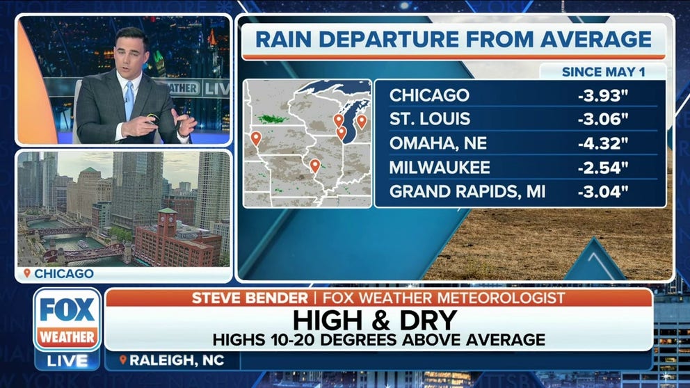
Flash drought developing in Midwest
The lack of rain over the past few weeks across the Great Lakes and Upper Midwest is likely to lead to a flash drought, in which drought rapidly develops over a short period. According to NOAA, a flash drought is often preceded by abnormally high temperatures, high winds and changes in solar radiation.
WHY SUMMER SHOULD ACTUALLY BEGIN ON JUNE 1

(FOX Weather)
Chicago hasn't picked up more than a half-inch of rain within 24 hours in nearly 50 days at O'Hare, according to the FOX Forecast Center. The city's biggest rain event this past month was on May 8, when 0.16 inches of rain was recorded.
While isolated showers and thunderstorms are possible in the Chicago area Wednesday and Thursday, there is no widespread, significant rainfall in the forecast for at least the next week.
"When we look at how much rain we actually need in a lot of these areas, Chicago, you're about 4 inches below where you should be in terms of your average," FOX Weather meteorologist Kiyana Lewis said. "So when we have days of this warm weather, we are looking at, unfortunately, flash drought in store."

(FOX Weather)