Flood threat in Northeast expected to end on Thursday
Flood Watches were in effect for more than 31 million people from New Jersey to Massachusetts through Thursday.
Flooding rains threaten Northeast on Wednesday
After a brief break Tuesday night, the next storm is already dropping heavy rain over the Mid-Atlantic and will slide into the Northeast later Wednesday.
NEW YORK – Following a day of dousing rain, those living along and east of the Interstate 95 corridor faced the risk of flash flooding from another storm system that moved through the Northeast.
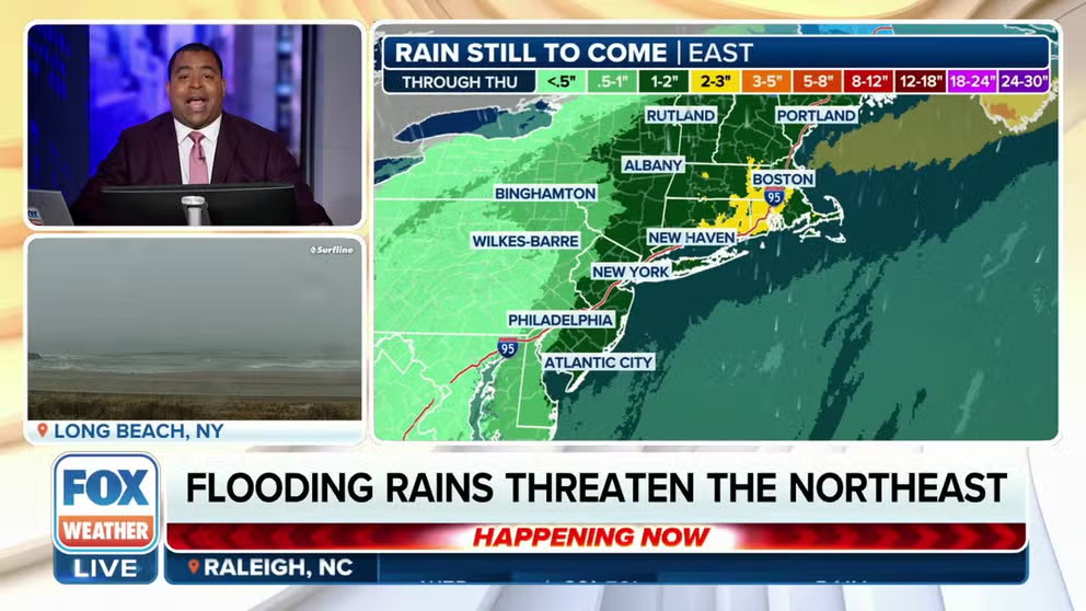
Major cities along the I-95 corridor, like Philadelphia, New York City, and Boston, were expected to pick up 2-3 inches of rain, while parts of Rhode Island and Long Island, New York, saw locally heavier amounts.
A travel advisory was issued by New York City Emergency Management due to heavy rain and possible flooding from Wednesday afternoon to Thursday morning.
DOWNLOAD THE FREE FOX WEATHER APP

(FOX Weather)
While the rain is not expected to be overly heavy due to a lack of atmospheric instability, the combination of the rain's persistence, well-above-average moisture for this time of year and already-saturated soils in southern New England from last weekend's rain will lead to a risk for flash and river flooding.
HOW HEAVY IS IT REALLY GOING TO RAIN?

(FOX Weather)
"This next storm that's moving in from the South is also going to bring in Gulf moisture," FOX Weather Meteorologist Britta Merwin said. "So I think we have a larger potential of maybe having a flooding concern for the end of the week."
"Interesting to see that hot spot in New England," Merwin added. "That's probably where we have the highest potential of flooding."

(FOX Weather)
With temperatures remaining relatively above average across the majority of the Northeast, the snow potential remains solely focused on northern Maine, the FOX Forecast Center said.
The rain will slowly move out Thursday before shifting into the Atlantic Ocean and Canadian Maritimes.
The next chance of snow will come this weekend as an area of low pressure moves in from the Midwest, according to the FOX Forecast Center. The forecast remains highly uncertain as computer forecast models are still figuring out where the low will track and whether enough cold air will be in place for significant winter weather.

(FOX Weather)