Northeast bracing for heavy rain, possible flooding Friday
A flash flooding threat exists for the area as 1-2 inches of rain could fall with locally higher amounts
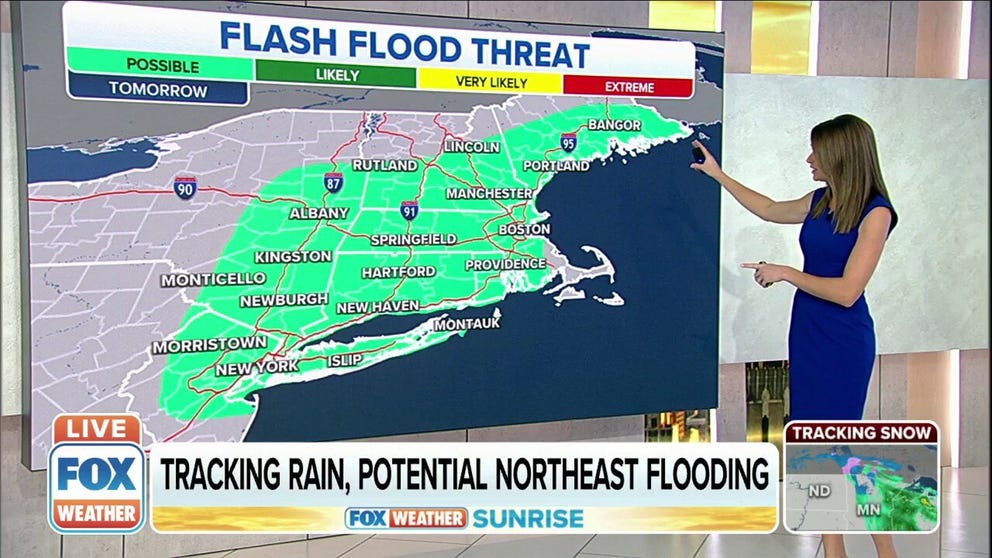
Northeast faces potential flooding on Friday
The Northeast faces potential flooding on Friday.
A cold front that continues to march east across the country will bring heavy rain and thunderstorms to the Northeast starting Friday.
![]() Image 1 of 2
Image 1 of 2A cold front will bring rain and storms from the Upper Midwest to the Lower Mississippi Valley Thursday morning. ( )
![]() Image 2 of 2
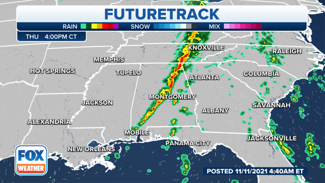
Image 2 of 2The front will continue to march east on Thursday, and the rain will move into the Ohio and Tennessee valleys later in the day. ( )
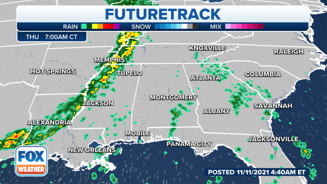
The front is currently moving through the central part of the country, where rain is falling from the Upper Midwest to the Lower Mississippi Valley. This system is now producing wind-driven snow for parts of the Northern Plains, where blizzard warnings are currently in effect.
It will continue to move east on Thursday, where rain is expected from the Upper Great Lakes and Ohio Valley, south into the Tennessee Valley and Southeast.
By Friday morning, the rain will have moved into the Mid-Atlantic and Northeast. Before the morning rush, heavier showers are expected from northern New York, south through Pennsylvania, Maryland, and Washington D.C.
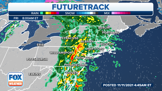
The Friday morning commute will be a bit slower for a large part of the Northeast as heavy rain is expected by 8 a.m.
(FOX Weather)
By around 8 a.m., the heavier showers and possible thunderstorms will be moving through places like Albany, Philadelphia and Dover. Drivers will need to allow for extra time on the roads as conditions will likely be slippery in those areas.
The rain will be clearing out in places like New York City and Washington, D.C., by about 1 p.m., which will make the evening commute Friday a bit easier than the morning commute for drivers in the I-95 corridor.
It will take a little longer for the front to reach places like Hartford, Providence and Boston. So those areas will likely see a smooth ride during the morning commute, but you'll need to allow for extra time across the Northeast and New England for the evening commute, as that is when the heaviest of the rain is expected to be falling.
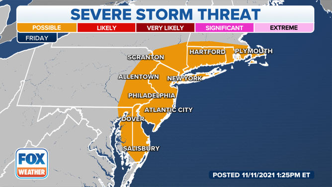
Severe thunderstorms are possible from the Mid-Atlantic into New England on Friday.
The Storm Prediction Center said there’s a marginal risk for severe thunderstorms from the Mid-Atlantic into New England on Friday afternoon as the strong front moves through the area. The main threats would be the heavy rain and strong winds associated with the storms.
However, there is also the risk for a few tornadoes in southern New England on Friday afternoon when the heaviest of the rain and storms push through the area.
The main areas of concern for possible tornadoes include areas from northern New Jersey, east across New York City and Long Island, Connecticut, Rhode Island and southern Massachusetts.
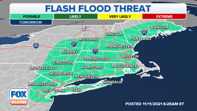
There is the potential for some flooding as the heavy rain moves through the region Friday.
(FOX Weather)
There is the potential for some flooding from northern New Jersey and New York City across New England through coastal Maine as the strong front moves through. It won't be a widespread flood event. Still, forecasters say that all of the recent rain in the area has made the region a bit saturated, so that's why there's a concern for some isolated flooding during the day Friday.
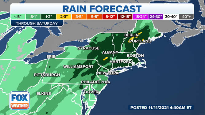
Most areas will see about 1 to 2 inches of rain, but some areas could see some higher totals.
(FOX Weather)
There isn't expected to be any blockbuster rain totals as the front moves through. A general 1 to 2 inches of rain is expected in southeastern Connecticut, Hartford, Boston, Albany and Portland. However, some local reports of 2 to 3 inches of rain can't be ruled out by the time things begin to clear out later on Friday afternoon and evening.
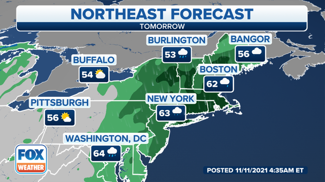
Temperatures will generally be in the mid-50s to mid-60s during the rain event Friday.
(FOX Weather)
If there is one, the silver lining is that temperatures aren't expected to be too chilly. Generally, temperatures will be in the mid-60s in places like Washington, D.C., New York City and Boston. Cooler temperatures are expected further north into Burlington, Vermont and Bangor, Maine, where temperatures will be in the lower to mid-50s.