Will it be a snowy winter? Some see increase in chances, latest NOAA outlook shows
NOAA's monthly U.S. and global climate report was released on Thursday, offering a refresh on the La Niña winter outlook and updated temperature, precipitation and drought forecasts for the next three months.
Experience the serenity of falling snow in these peaceful winter scenes
Sit back and relax for 90 seconds of peaceful falling snow.
Were you disappointed with the forecast last month when NOAA meteorologists released their outlook predicting the type of weather expected this winter? The same climate and weather experts have provided a new monthly update, which has changed slightly.
Yes, winter will still officially start on Dec. 21, but if you live to the north, it might feel like it's already here.
NOAA's monthly U.S. and global climate report was released on Thursday, offering a refresh on the La Niña winter outlook and updated temperature, precipitation and drought forecasts for the next three months.
This comes a month after NOAA's 2022-23 winter outlook predicted drier-than-average conditions across the South with wetter-than-average conditions for areas of the Ohio Valley, Great Lakes, northern Rockies and Pacific Northwest, all of which are very typical for the La Niña pattern.
Here's a closer look at an updated outlook from December-February.
Temperature outlook
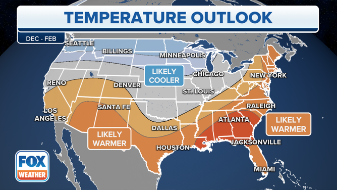
Here's a look at NOAA's temperature outlook map for temperature from December-February.
(FOX Weather)
NOAA's Climate Predication Center said the December-February temperature outlook depicts elevated odds of below-normal temperatures over the northern U.S., stretching from the Pacific Northwest to parts of the western Great Lakes. It's also favored for the Alaska Panhandle and southeastern parts of Alaska.
HOW TO WATCH FOX WEATHER ON TV
Above-normal temperatures are more likely over the southwestern U.S., stretching across the southern U.S. and into the Northeast.
The highest probabilities for above-normal temperatures are found over the Gulf Coast states. Over in Alaska, above-normal temperatures are most likely over the
northwestern parts of the state.
Precipitation outlook
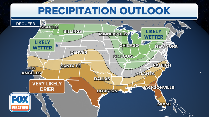
Here's a look at NOAA's precipitation outlook map for temperature from December-February.
(FOX Weather)
The precipitation outlook for the same time 90-day period favors above-normal precipitation over the Pacific Northwest through parts of the Northern Plains, as well as over the Great Lakes and Ohio and Tennessee Valley regions, NOAA said.
Elevated odds of below-normal precipitation are favored over the southern third of the U.S., with the highest probabilities over parts of southeastern New Mexico and southern Texas, as well as parts of the Gulf Coast States.
Over Alaska, a tilt toward above normal precipitation is favored over western Alaska, while enhanced probabilities of below normal precipitation are favored over parts of the South Coast.
The remainder of the U.S., NOAA said, will fall into the category of equal chances for below-, near- or above-average seasonal total precipitation.
Drought outlook
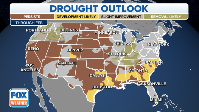
Here's a look at the current U.S. drought outlook.
(FOX Weather)
Despite swaths of heavy precipitation to northeastern Texas, Arkansas and the middle and upper Mississippi Valley, a northern Plains winter storm and remnants of Hurricane Nicole in the Northeast, drought coverage remains extensive across the contiguous United States.
According to NOAA, persistently dry and warm conditions for this time of year resulted in an unusually widespread and rapid development of autumn drought conditions across the Plains, Midwest and Southeast during the past month.
As of Nov. 1, abnormal dryness and drought conditions blanketed over 85% of the contiguous United States, which is the most on record since the inception of the U.S. Drought Monitor, NOAA states.
What is a La Niña?
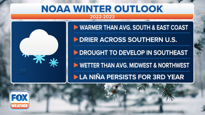
This year La Niña returns for the third consecutive winter, driving warmer-than-average temperatures for the Southwest and along the Gulf Coast and eastern seaboard, according to NOAA’s U.S. Winter Outlook.
(FOX Weather)
La Niña happens when there is abnormal cooling of the water in the central and eastern tropical regions of the Pacific Ocean. This pattern typically creates warmer and drier conditions across the southern U.S., while colder and wetter conditions usually occur across the northern tier.
The current La Niña state is expected to continue with a 76% chance it holds through February followed by 57% chance of a transition to neutral conditions (neither an El Niño nor La Niña) in February-April.
WHAT ARE EL NINO AND LA NINA CLIMATE PATTERNS?
La Niña differentiates itself from an opposite El Niño effect, which is when tropical Pacific Ocean waters become warmer than average.
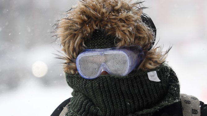
A woman wearing goggles walks through the snow on January 4, 2018, in Brooklyn, New York.
(ANGELA WEISS / AFP / Getty Images)
Seasonal outlooks: Hit or miss?
NOAA produces seasonal outlooks to help the nation prepare for likely weather and climate patterns during the next few months to help minimize negative impacts on lives and livelihoods. But just how on-target are these seasonal outlooks?
WINTER PREDICTION SCOREBOARD: HOW ON-TARGET ARE SEASONAL OUTLOOKS?
Since 1995, many of the seasonal temperature outlooks have ranged between zero and 40 on the Heidke Skill Score (HSS) – a score of 100 means the outlook was perfect. Only three times has the HSS come in at 80 or above, depicting nearly pinpoint accuracy.
In the winter of 2020-21, both temperature and precipitation outlooks came in below zero, indicating more inaccuracies than precisions in the outlook.
FARMER’S ALMANAC DECLARES PART OF US ‘HIBERNATION ZONE’ WITH PREDICTED ‘GLACIAL, SNOW-FILLED’ WINTER
Are you tired of weather apps with endless numbers that offer no context or help to understand the weather? Put the power of over 100 meteorologists and the worldwide resources of FOX in your hands with the free FOX Weather app. See and interact with the forecast for today and 14 days into the future, along with hourly details for the next 48 hours.