Nicholas poses life-threatening flash flood risk in Deep South following Texas landfall as hurricane
Up to 20 inches of rain is possible in parts of Louisiana

Nicholas poses life-threatening flash flood risk following Texas landfall as hurricane
Tropical Storm Nicholas made landfall as a hurricane in Texas early Tuesday morning.
Tropical Storm Nicholas made landfall as a hurricane in Texas early Tuesday morning, and it will move slowly over the Deep South the next couple of days, posing a life-threatening flash flood risk from southeastern Texas to Louisiana and Mississippi.
Nicholas made landfall as a Category 1 hurricane with maximum sustained winds of 75 mph about 12:30 a.m. Central time Tuesday on the eastern part of the Matagorda Peninsula, some 10 miles west-southwest of Sargent Beach, Texas, according to the National Hurricane Center.
As of 7 a.m. Central, Nicholas was a tropical storm with winds of 60 mph. It was centered about 15 miles south-southwest of Houston and was moving north-northeastward at 8 mph toward the Houston metro area.
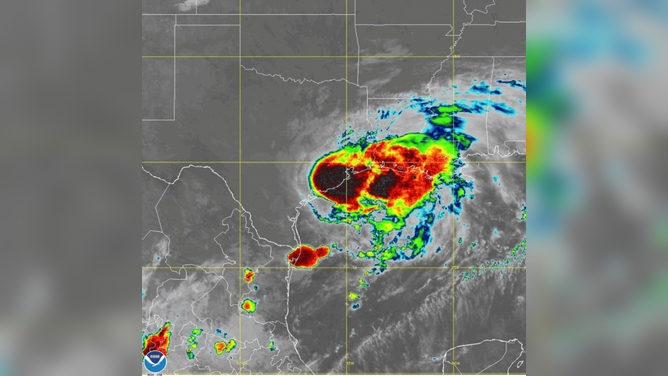
Tropical Storm Nicholas was seen over southeastern Texas Tuesday morning, Sept. 14, 2021.
(NOAA)
Tropical storm warnings and storm surge warnings and watches are posted for parts of southeastern Texas and southwestern Louisiana:
- A Tropical Storm Warning is in effect from San Luis Pass, Texas, to Cameron, Louisiana.
- A Storm Surge Warning is in effect from San Luis Pass, Texas, to Sabine Pass, including Galveston Bay.
- A Storm Surge Watch is in effect from Sabine Pass to Rutherford Beach, Louisiana.
The latest forecast from the NHC indicates Nicholas will move slowly northeastward along the southeastern Texas coast on Tuesday, then turn eastward by Wednesday over Louisiana. By Thursday, it's expected to stall over southern Louisiana.
Nicholas is forecast to weaken to a tropical depression by Wednesday morning, but that does not have any effect on its rainfall potential.
WATER FROM HURRICANES, TROPICAL STORMS KILLS MORE IN U.S. THAN WIND

Forecast track for Tropical Storm Nicholas as of 7 a.m. Central time Tuesday, Sept. 14, 2021.
(NOAA/NHC)
Life-threatening flash flood risk in Deep South
While gusty winds will accompany Nicholas, the biggest threat from the storm, by far, is flash flooding.
The NHC is warning of additional rainfall amounts of 5 to 10 inches from the upper Texas coast into central and southern Louisiana, far southern Mississippi and far southern Alabama. Isolated storm totals of 20 inches are possible across central and southern Louisiana, where Nicholas is forecast to stall by Thursday.
"Life-threatening flash flooding impacts, especially in urbanized metropolitan areas, are possible across these regions," the NHC said Tuesday morning.
The rainfall forecast for Tropical Storm Nicholas as of Tuesday morning, Sept. 14, 2021.
(NOAA/NWS/WPC)
NOAA's Weather Prediction Center has highlighted portions of the far southeastern Texas coast and southwestern Louisiana for a rare high risk (level 4 out of 4) of excessive rainfall through Wednesday morning. This includes Lake Charles, Louisiana.
Other parts of southeastern Texas and central and southern Louisiana have a moderate risk (level 3 out of 4) of excessive rainfall through Thursday morning.
WHY RARE ‘HIGH RISK’ FLOOD DAYS NEED TO BE TAKEN SERIOUSLY
The three-day excessive rainfall outlook issued by NOAA's Weather Prediction Center Tuesday morning, Sept. 14, 2021.
(NOAA/NWS/WPC)
Storm surge
Tropical Storm Nicholas also poses a risk of dangerous storm-surge flooding along parts of the southeastern Texas and southwestern Louisiana coastlines.
The largest storm surge of 3 to 5 feet is predicted from San Luis Pass, Texas, to High Island, Texas, including Galveston Bay. A surge of 2 to 4 feet is forecast from High Island, Texas, to Rutherford Beach, Louisiana. A 1- to 3-foot surge is expected along other parts of the coastline as far west as Aransas, San Antonio and Matagorda bays in Texas and as far east as Intracoastal City, Louisiana.
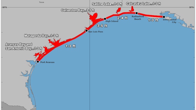
Storm-surge forecast for Tropical Storm Nicholas as Tuesday morning, Sept. 14, 2021.
(NOAA/NHC)