National severe weather forecast streak reaches second-longest stretch since 2014
Friday marks 46 consecutive days with somewhere in the nation warranting at least a level 2 rating on the severe weather outlook.

Severe Weather Chart Spring 2022
(FOX Weather)
NORMAN, Okla. -- It's been a very busy spring so far for meteorologists keeping tabs on severe weather, and Mother Nature hasn't given much of a break.
NOAA's Storm Prediction Center is responsible for daily severe weather outlooks, and will highlight areas of concern each day using a five-point scale of expected impacts.
THE 5-POINT SEVERE THUNDERSTORM RISK CATEGORY SCALE EXPLAINED
Friday marked 46 consecutive days with somewhere in the nation warranting at least a level 2 rating on the severe weather outlook.
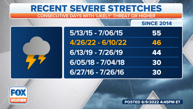
Recent Severe Stretches
(FOX Weather)
That is the second-longest streak of at least a level two since the scale was implemented in October of 2014. The record-longest streak is 55 days set from May 13 to July 6 in 2015.
7 OF OUR FAVORITE LIGHTNING VIDEOS FROM SPRING 2022
The streak just passed third place which was June 13-July 26 in 2019.
It looked like as of Friday evening the streak would end Saturday as SPC's outlook for Saturday had only shown a Level 1 concern for severe weather.
NEARLY 4,400 SEVERE WEATHER REPORTS HIGHLIGHT BUSY MAY ACROSS U.S
But the streak was extended Saturday morning when SPC forecasters decided the severe weather threat was greater and hoisted level 2 outlooks for parts of South Dakota, Montana and the greater Kansas City / Omaha areas.

(FOX Weather)
The streak should continue Sunday with Level 2 "likely" outlooks forecast for western South Dakota and Nebraska.
ADVICE FOR DEALING WITH STORM ANXIETY WHEN SEVERE WEATHER THREATENS

(FOX Weather)