Severe weather outbreak leaves 3 dead as tornadoes tear across multiple states
At least three people have been killed in one tornado, while many others were injured, according to local and state officials.
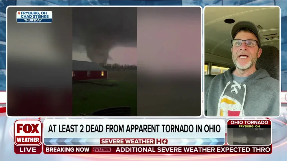
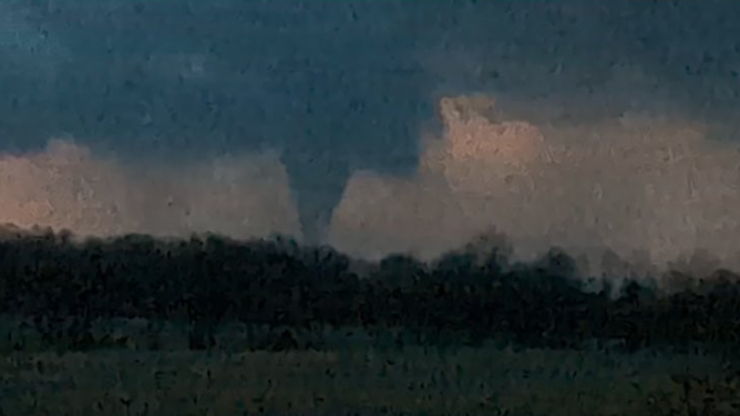
Fryburg, Ohio resident captures powerful tornado tearing through town
A powerful tornado was seen spinning through Fryburg, Ohio, on Thursday just before it moved east and caused destruction in Indian Lake. Fryburg resident Chad Steinke joins FOX Weather to discuss his experience witnessing this devastating tornado.
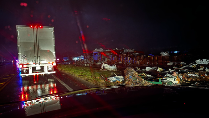
LAKEVIEW, Ohio – A deadly severe weather outbreak swept across the Southern Plains and Midwest into the Ohio Valley on Thursday, spawning at least 20 tornadoes and leaving trails of damage across multiple states.
Three people have been killed in one tornado in Ohio, while dozens were injured in a tornado in Indiana, according to local and state officials.
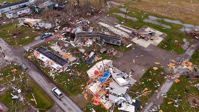
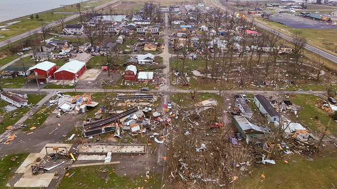
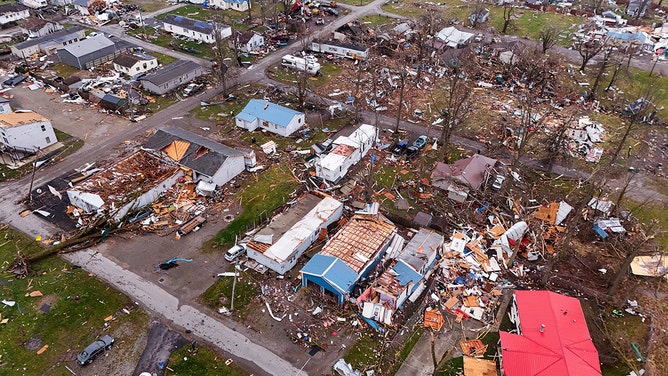
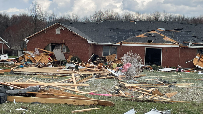
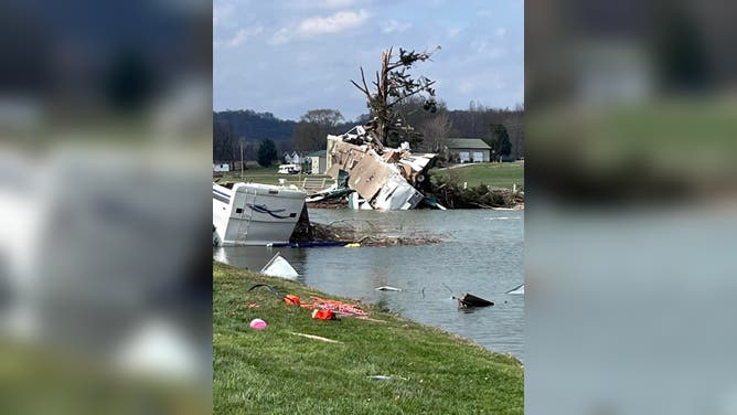
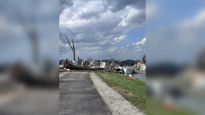
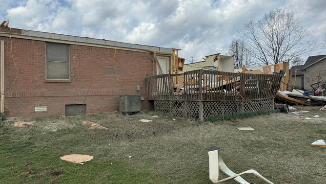
Tornado damage scene around Indian Lake Friday morning in Logan County, Ohio
(From Above Aerial LLC)
Deadly tornado sweeps through Northern Ohio
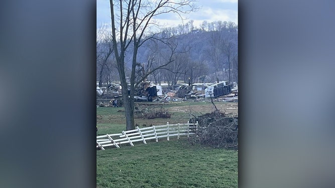
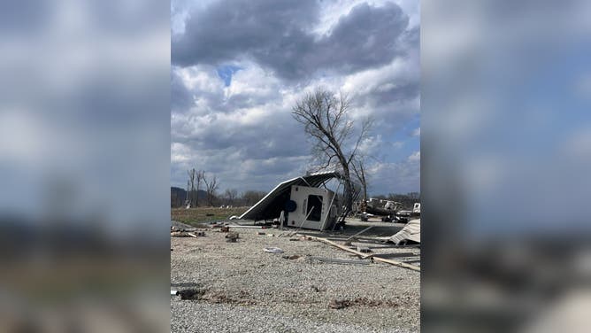
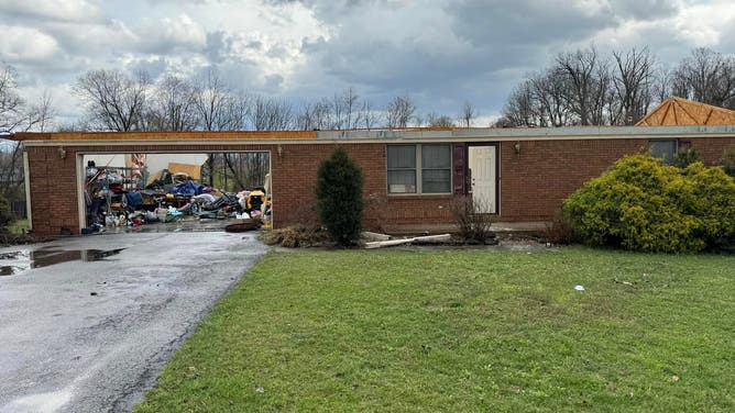
The three deaths in Ohio occurred when a tornado tore through Logan County on Thursday night, according to Chief Deputy Joe Kopus with the sheriff's office.
Heavy damage was also reported throughout Lakeview, Midway, Orchard Island and Russel's Point.
As of Saturday morning, Logan County authorities said search and rescue had been completed as crews begin to move into the recovery phase.
"The area is still very dangerous," officials said in a joint statement with the Logan County EMA and Logan County Sheriff’s Office. "We urge caution to everyone. Damage assessments will begin tomorrow (Sunday)."
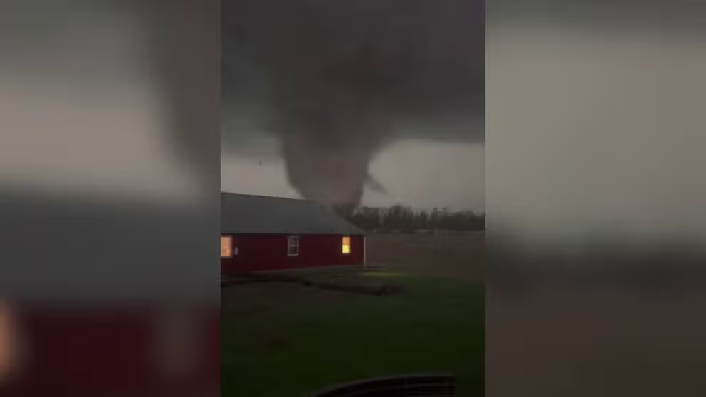
Watch: Powerful tornado spins through Fryburg, Ohio
A powerful tornado was seen spinning through Fryburg, Ohio, on Thursday. A deadly severe weather outbreak swept across the Southern Plains and Midwest into the Ohio Valley, spawning several tornadoes and leaving trails of damage across multiple states.
The National Weather Service said at least nine tornadoes struck Ohio, with the Logan County twister being the strongest at an EF-3.
![Tornado damage scene around Indian Lake Friday morning in Logan County, Ohio]() Image 1 of 20
Image 1 of 20Tornado damage scene around Indian Lake Friday morning in Logan County, Ohio (From Above Aerial LLC)
![Tornado damage scene around Indian Lake Friday morning in Logan County, Ohio]() Image 2 of 20
Image 2 of 20Tornado damage scene around Indian Lake Friday morning in Logan County, Ohio (From Above Aerial LLC)
![Tornado damage scene around Indian Lake Friday morning in Logan County, Ohio]() Image 3 of 20
Image 3 of 20Tornado damage scene around Indian Lake Friday morning in Logan County, Ohio (From Above Aerial LLC)
![Tornado damage scene around Indian Lake Friday morning in Logan County, Ohio]() Image 4 of 20
Image 4 of 20Tornado damage scene around Indian Lake Friday morning in Logan County, Ohio (From Above Aerial LLC)
![Tornado damage scene around Indian Lake Friday morning in Logan County, Ohio]() Image 5 of 20
Image 5 of 20Tornado damage scene around Indian Lake Friday morning in Logan County, Ohio (From Above Aerial LLC)
![Tornado damage scene around Indian Lake Friday morning in Logan County, Ohio]() Image 6 of 20
Image 6 of 20Tornado damage scene around Indian Lake Friday morning in Logan County, Ohio (From Above Aerial LLC)
![Tornado damage scene around Indian Lake Friday morning in Logan County, Ohio]() Image 7 of 20
Image 7 of 20Tornado damage scene around Indian Lake Friday morning in Logan County, Ohio (From Above Aerial LLC)
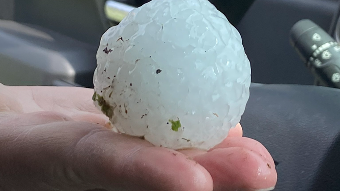
![Large hail damages patrol cars in Southern Indiana]() Image 8 of 20
Image 8 of 20Large hail damages patrol cars in Southern Indiana (Indiana State Police)
![Large hail damages patrol cars in Southern Indiana]() Image 9 of 20
Image 9 of 20Large hail damages patrol cars in Southern Indiana (Indiana State Police)
![Reported tornado damage in Southern Indiana]() Image 10 of 20
Image 10 of 20Reported tornado touches down in Jefferson County, Indiana on March 14, 2024. (Indiana State Police)
![Reported tornado damage in Southern Indiana]() Image 11 of 20
Image 11 of 20Reported tornado touches down in Jefferson County, Indiana on March 14, 2024. (Indiana State Police)
![Reported tornado damage in Southern Indiana]() Image 12 of 20
Image 12 of 20Reported tornado touches down in Jefferson County, Indiana on March 14, 2024. (Indiana State Police)
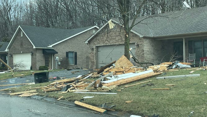
![Damage is seen following a tornado in Madison, Indiana, on March 14, 2023.]() Image 13 of 20
Image 13 of 20Damage is seen following a tornado in Madison, Indiana, on March 14, 2023. (Tony Novello)
![Severe storms move through Madison, Indiana, on March 14, 2023.]() Image 14 of 20
Image 14 of 20Severe storms move through Madison, Indiana, on March 14, 2023. (Tony Novello)
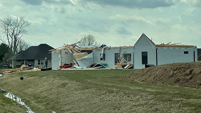
![Reported tornado damage in Southern Indiana]() Image 15 of 20
Image 15 of 20Damage is seen following a tornado in Jefferson County, Indiana, on March 14, 2023. (Jefferson County (Indiana) Sheriff's Office)
![Reported tornado damage in Southern Indiana]() Image 16 of 20
Image 16 of 20Damage is seen following a tornado in Jefferson County, Indiana, on March 14, 2023. (Jefferson County (Indiana) Sheriff's Office)
![Reported tornado damage in Southern Indiana]() Image 17 of 20
Image 17 of 20Damage is seen following a tornado in Jefferson County, Indiana, on March 14, 2023. (Jefferson County (Indiana) Sheriff's Office)
![Reported tornado damage in Southern Indiana]() Image 18 of 20
Image 18 of 20Damage is seen following a tornado in Jefferson County, Indiana, on March 14, 2023. (Jefferson County (Indiana) Sheriff's Office)
![Reported tornado damage in Southern Indiana]() Image 19 of 20
Image 19 of 20Damage is seen following a tornado in Jefferson County, Indiana, on March 14, 2023. (Jefferson County (Indiana) Sheriff's Office)
![Severe storms damage a marina in Orchard Island, Ohio, on Thursday, March 15, 2024.]() Image 20 of 20
Image 20 of 20Severe storms damage a marina in Orchard Island, Ohio, on Thursday, March 15, 2024. (WSYX)


"We’re heartbroken by the devastation that’s come upon the Indian Lake community in the last several hours," said Logan County Commissioner Joe Antram, who said he is a lifelong resident of the community. "We very much appreciate the fact that there’s been such an outreach — not just in the local community in Indian Lake and the county, but in fact many counties around us, and we appreciate the gesture."
On Monday, authorities identified the three Logan County victims as 69-year-old Neal Longfellow, 70-year-old Darla Willimas and 81-year-old Marilyn Snapp.
Nearby Mercer County also sustained tornado damage, with emergency management reporting at least 3 injuries.
"We have several homes damaged," Mercer County Emergency Management Director Mike Robbins told FOX Weather.
PowerOutage.us reported nearly 20,000 electrical outages in Ohio at the height of the storm, with many occurring between the Interstate 70 and 90 corridors.
Tornado damage in Indian Lakes, Ohio
(@CBJ_Dad0424)
A tornado that struck New Washington, Ohio caused extensive damage to homes and power poles along its 10-mile path from Crawford County into Richland County, according to the National Weather Service in Cleveland. The agency rated the storm an EF-2 with estimated wind speeds of 120 mph.
Another tornado - this one rated EF-1 - damaged five homes and several farm buildings in Hancock County near Orange Township, the NWS said.
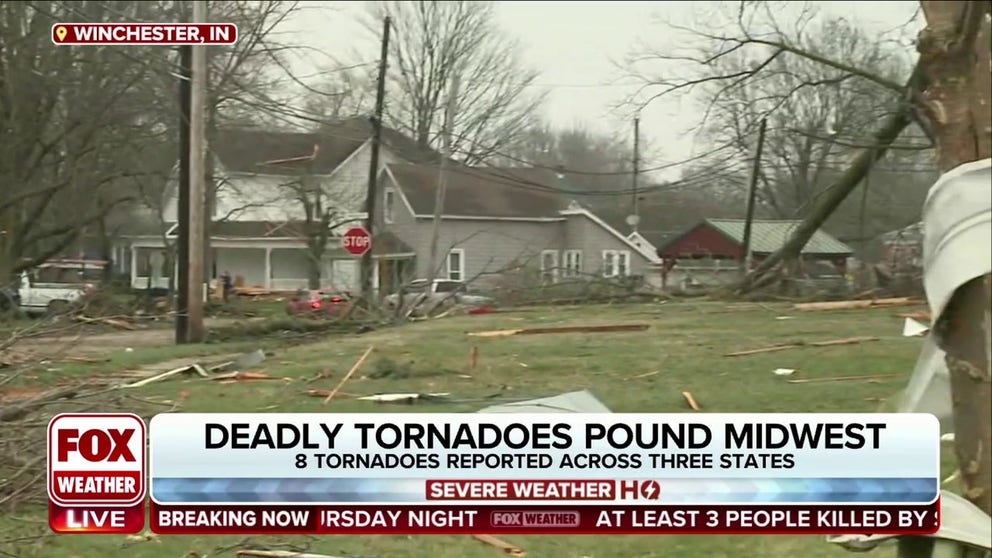
Dozens injured in Indiana tornado
Another tornado tore through the town of Winchester, Indiana, leaving 38 injured, but so far no deaths, according to Randolph County Emergency Management. Twelve of the injured required hospitalization, but locals consider it a miracle that no one was killed.
Urban search and rescue teams are on the scene helping first responders in searching damaged structures, but there are no reports of anyone missing.
The NWS office in Indianapolis surveyed of the some damage and determined that winds speeds reached 155-165 mph, making the twister an EF-3.
Tornado reported in Winchester, Indiana
(FOX Weather)
"We’re in the basement, we hear the (tornado) sirens go off and we hear a freight train," said Lydia Carpenter. "Everyone says it sounds like a freight train and we could hear it. It was crazy."
Winchester Community High School was not damaged during the storms and was opened for victims.
"Winchester – we were a beautiful town and will be a beautiful town again, we just need all the help we can get," Carpenter said.
Nearby Delaware County reported that at least 50% of structures in the town of Selma were damaged, but there were no reports of life-threatening injuries.
Tornado leaves a trail of damage in Indiana
One resident of Winchester, Indiana said a massive tornado that swept through the historic town sounded like a freight train.
"Janet and I send our deepest condolences and prayers to the loved ones of those impacted by tonight's storms and the Hoosiers in the path of destruction," Indiana Governor Eric Holcomb said in a statement. "The people of Winchester are resilient and should know the state will walk alongside and support them as we pick up the pieces and rebuild."
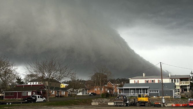
Video shows tornado crossing Ohio River
A supercell that rolled through southern Indiana and northern Kentucky produced at least one tornado caught on video as it crossed the Ohio River near Madison, Indiana.
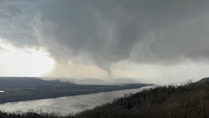
A tornado spins through Madison, Indiana, on March 14, 2023.
(Tony Novello)
Local National Weather Service offices issued Tornado Warnings for the thunderstorm. According to PowerOutage.us, at least 5,000 customers in the immediate area lost electricity.
Photos and video from the region showed debris being lofted by the twister. Damage was reported in the towns of Milton and Carrollton along the Ohio River in Kentucky.
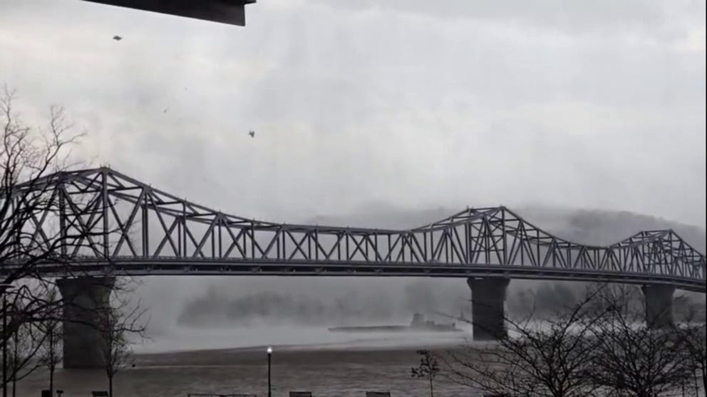
Tornado attempts to cross Ohio River near Kentucky-Indiana border
Video taken of a tornado near Madison, Indiana on Thursday. Debris was lofted in the air.
The NWS office in Louisville dispatched a team of meteorologists to Milton, Kentucky, to assess damage and determine how strong the tornado was on the Enhanced Fujita Scale.
According to the team, some damage was consistent with an EF-2 tornado with winds greater than 110 mph.
Kentucky Gov. Andy Beshear declared a state of emergency after the severe storms and reported more than 100 buildings suffered damage.
Severe storms move through Madison, Indiana, on March 14, 2023.
(Tony Novello)
Indiana State Police deployed to Jefferson County in the southern part of the state said multiple homes were damaged between Hanover and Madison and encouraged drivers to avoid the region.
Several patrol cars were also said to have been damaged by hailstones the size of baseballs.
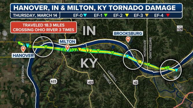
A map of a storm survey conducted by the National Weather Service showed that the twister that began in Hanover, Indiana, on March 14, 2024, crossed the Ohio River three times.
(FOX Weather)
Hundreds of storm reports stretched over 1,000 miles
Aside from the tornadoes, millions were under threat of severe weather throughout Thursday evening and night.
The National Weather Service issued over 90 Tornado Warnings and 350 Severe Thunderstorm Warnings across 11 states, stretching over 1,000 miles from Texas to Pennsylvania.
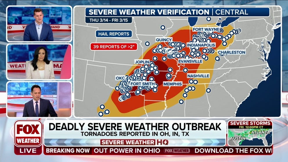
Hundreds of severe weather alerts were issued over 1,000 miles Thursday
FOX Weather's Marissa Torres, Stephen Morgan and Craig Herrera show how the atmospheric ingredients came together to make a widespread severe weather threat Thursday that covered parts of 11 states.
Amid the storms, spotters reported 342 instances of severe-weather events, including at least eight tornadoes and 120 reports of damaging wind gusts.
Wednesday damage reports
Thursday's outbreak came on the heels of a rather stormy Wednesday too, when around 100 reports of severe weather were recorded by the National Weather Service, making it now the fifth-most active day of 2024. In Alma, Kansas, a report of softball-sized hail (4 inches in diameter) tied the largest hail report of the year so far.
THIS IS WHAT YOU SHOULD DO IF YOU ARE DRIVING AND THERE IS A TORNADO ON THE GROUND
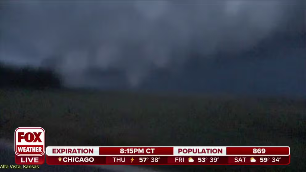
Tornado caught on video by FOX Weather Storm Tracker
A significant tornado was spotted outside of the town of Alta Vista in Northeast Kansas on Wednesday evening.
FOX Weather Storm Trackers were also in the right place at the right time and captured video of a supercell producing a large tornado outside of the town of Alta Vista in northeastern Kansas. There were no reports of significant damage, but about 200 customers in the rural area experienced a power outage.