Tornadoes threaten millions as severe storm blast the Midwest and Great Lakes
Several confirmed tornadoes slammed Iowa as severe storms moved through the Midwest and Great Lakes on Thursday.

FOX Weather Storm Trackers hunt down reported tornado in Iowa
FOX Weather Storm Tracker Corey Gerkin and Brandon Copic are in Iowa tracking down a reported tornado, while FOX Weather Meteorologist Ian Oliver analyzes the threat from the studio.
CHICAGO, Ill. — Several confirmed tornadoes slammed Iowa on Thursday, with cities such as Chicago, Milwaukee and several other Midwest metro areas also seeing the impacts of severe storms.
Dangerous severe weather is impacting more than 45 million people across the region — with storms firing over eastern Iowa before charging east.
According to NOAA's Storm Prediction Center, thunderstorms capable of producing a strong tornado (EF 2+) are likely across parts of Chicagoland, Rockford as well as parts of southern Wisconsin and eastern Iowa.
ARTEMIS II MAKES HISTORY, BRINGING HUMANS AROUND THE MOON FOR THE FIRST TIME IN 50 YEARS
![Devastating tornado caught on camera in Union City, Michigan]() Image 1 of 6
Image 1 of 6Devastating tornado caught on camera in Union City, Michigan (Lisa Nicola)
![Photos from the ground in Aroma Park, Illinois, on March 12 capture the devastating destruction in Kankakee County after a tornado ripped through March 10]() Image 2 of 6
Image 2 of 6Photos from the ground in Aroma Park, Illinois, on March 12 capture the devastating destruction in Kankakee County after a tornado ripped through March 10. (FOX Weather Correspondent Katie Byrne )
![LAKE VILLAGE, INDIANA - MARCH 10: First responders survey a destroyed Family Dollar store where two employees were trapped and later rescued uninjured after a tornado struck on March 10, 2026 in Lake Village, Indiana. The National Weather Service had issued an urgent warning about a large tornado moving through the area, calling it a "life-threatening situation."]() Image 3 of 6
Image 3 of 6LAKE VILLAGE, INDIANA - MARCH 10: First responders survey a destroyed Family Dollar store where two employees were trapped and later rescued uninjured after a tornado struck on March 10, 2026, in Lake Village, Indiana. The National Weather Service had issued an urgent warning about a large tornado moving through the area, calling it a "life-threatening situation." ((Photo by Michael Hickey/Getty Images))
![]() Image 4 of 6
Image 4 of 6Multiple buildings were torn apart in Kankakee, IL after a tornado impacted the area on March 10. (Downburst Daan / Facebook)
![Widespread tornado damage in Union City, MI, March 7.]() Image 5 of 6
Image 5 of 6Widespread tornado damage in Union City, MI, March 7. (Celena Sanchez / FOX Weather)
![BLOOMINGTON, INDIANA - FEBRUARY 19: Lightning streaks across the sky over west Bloomington as seen from Rosehill Cemetery on February 19, 2026, in Bloomington, Indiana. At least one tornado later touched down, damaging a bank, the animal shelter, and multiple homes and other structures.]() Image 6 of 6
Image 6 of 6BLOOMINGTON, INDIANA - FEBRUARY 19: Lightning streaks across the sky over west Bloomington as seen from Rosehill Cemetery on February 19, 2026, in Bloomington, Indiana. At least one tornado later touched down, damaging a bank, the animal shelter, and multiple homes and other structures. ((Photo by Jeremy Hogan/Getty Images))


A confirmed tornado was reported on Thursday afternoon in Johnson and Washington counties in Iowa around 4:20 p.m. CT. This moved through nearby towns that include Hills, Riverside and Richmond, Iowa.
The tornado was spotted by weather spotters as a rope tornado, according to the FOX Forecast Center. The National Weather Service will likely go out to survey for damage in the coming days.
A confirmed tornado also touched down near Preston and Van Buren, Iowa. A debris signature was seen on radar around 5:45 p.m. CT, with reports of damage to buildings and trees in the area.
This threat comes as an active weather pattern takes hold in the Central U.S., as spring severe weather season intensifies across the Heartland following an active March which saw deadly tornadoes in Illinois, Indiana and Michigan.
Thunderstorms developed and intensified by late Thursday over the Central Plains and shifted into the Midwest and Great Lakes through the afternoon and into the evening.

(FOX Weather)
According to the FOX Forecast Center, damaging wind gusts of 75 mph or stronger and tornadoes are the primary severe weather hazards expected.
"Storms that do form are likely to be discrete supercells, which increases the tornado threat," the Forecast Center said.
GROUP OF HIKERS RESCUED AFTER BEING SWEPT AWAY BY FLASH FLOODING IN UTAH
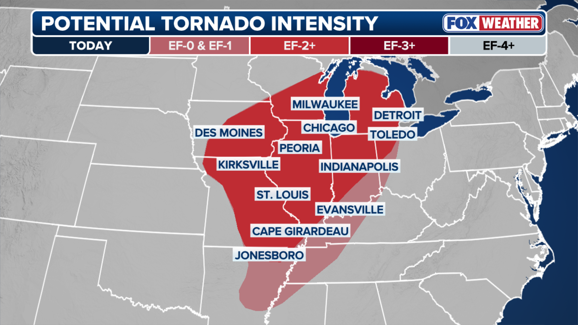
The risk of strong (EF-2+) tornadoes spans a corridor more than 700 miles long, from Missouri to Michigan.

(FOX Weather)
The Storm Prediction Center issued a Level 3 out of 5 risk of severe thunderstorms for southern Wisconsin, just south of Milwaukee; northern Illinois, including Chicago; and eastern Iowa.
NEW HAWAII BEACH ADVISORY ISSUED FOR HIGH BACTERIA AFTER HISTORIC FLOODING
(FOX Weather)
As storms weaken, heavy rain will remain, creating a localized flash flood threat late Thursday across Wisconsin, Michigan and northern Illinois. A widespread 1 to 2 inches of rain is expected across the Midwest and parts of the Great Lakes through Thursday.
WHAT FLOOD WATCHES, WARNINGS AND EMERGENCIES REALLY MEAN

(FOX Weather)
Severe weather threat reloads over Plains, Midwest Friday
A second severe weather system will move out of the Rockies and into the Plains by Friday afternoon.
Thunderstorms are expected to fire ahead of the associated cold front and organize into a line from western Iowa to West Texas by the mid-afternoon hours. All hazards are possible, including damaging winds, large hail and tornadoes.

(FOX Weather)
Parts of the Midwest are once again in the bulls-eye, where southern Iowa and northern Missouri are under a Level 3 threat — the greatest threat of seeing discrete supercells capable of producing tornadoes.
WHAT IS A SUPERCELL THUNDERSTORM?
Heavy rain will persist overnight Saturday, creating another flash flood threat from northern Texas into southwestern Missouri.
This active severe weather pattern comes right on cue, as April is historically when spring severe weather season begins to intensify across the middle of the country.