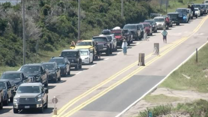
Long lines stretch at North Carolina ferry terminals as Hurricane Erin prompts evacuation orders
Although there is no direct impact expected on land in the U.S., the storm could bring life-threatening surf and flooding along the East Coast.
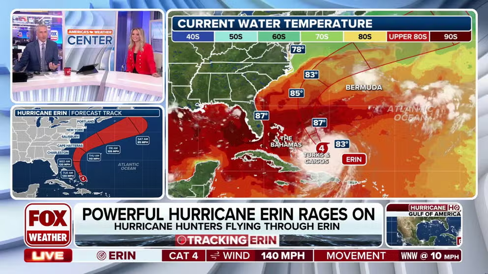
Hurricane Erin maintains intensity moving into warmer waters
FOX Weather Meteorologists Bob Van Dillen and Haley Meier provide the latest update on Monday, Aug. 18 for Hurricane Erin. The category 4 hurricane is maintaining 140 mph winds and is forecast to move along the U.S. East Coast with life-threatening coastal conditions.
OCRACOKE ISLAND, N.C. – Hurricane Erin continues to churn as the Category 4 storm moves across the Atlantic Ocean, prompting some areas along North Carolina's Outer Banks to begin evacuations.
Images shared by the North Carolina Ferry System on Monday afternoon showed the large line of island residents flocking to the evacuation site. The ferry system is assisting in the efforts to help people safely get off the vulnerable island.
![This image provided by the North Carolina Department of Transportation shows a line of vehicles waiting to evacuate Ocracoke Island ahead of life-threatening impacts from Hurricane Erin.]() Image 1 of 2
Image 1 of 2This image provided by the North Carolina Department of Transportation shows a line of vehicles waiting to evacuate Ocracoke Island ahead of life-threatening impacts from Hurricane Erin. (North Carolina Department of Transportation)
![This image provided by the North Carolina Department of Transportation shows a line of vehicles waiting to evacuate Ocracoke Island ahead of life-threatening impacts from Hurricane Erin.]() Image 2 of 2
Image 2 of 2This image provided by the North Carolina Department of Transportation shows a line of vehicles waiting to evacuate Ocracoke Island ahead of life-threatening impacts from Hurricane Erin. (North Carolina Department of Transportation)

Although there is no direct impact expected on land in the U.S., the storm could bring life-threatening surf and flooding along the East Coast.
Officials expect significant ocean overwash from the storm as portions of Highway 12 on Hatteras Island are expected to be impassable for the next several days.
In light of the recent storm threat, North Carolina Governor Josh Stein issued a state of emergency for Ocracoke Island.
Mandatory evacuations began on Sunday evening, starting with all visitors to the island, followed by all residents on Monday morning, according to the North Carolina Ferry System.
"Now is the time to secure property, finalize plans and evacuate with belongings," officials said from Dare County amid evacuation orders.