La Nina likely to hold through spring, then begin to fade
NOAA's Climate Prediction Center is giving a 77% chance La Nina conditions will last through spring, then give slightly favorable chances (56%) of neutral conditions taking hold in late spring into summer.
WASHINGTON, D.C. -- Our "Double Dip" La Niña that has been hanging around since last autumn is now forecast to remain in place through the spring, then fade away as we get into summer, according to NOAA's Climate Prediction Center.
La Niña is part of the 3-7 year cycle of warming and cooling temperatures in the central Pacific Ocean known as the El Nino-Southern Oscillation (ENSO). The warm phase (El Niño) and cool phase (La Niña) have widespread influence on global weather patterns and have become essential seasonal forecasting tools.
La Niña patterns typically lead to wetter winters in the Pacific Northwest and Ohio/Tennessee Valley, with dry winters in the south and southwest. The pattern also brings a cooler than average winter to the Northwest and above-average temperatures along the southeast.
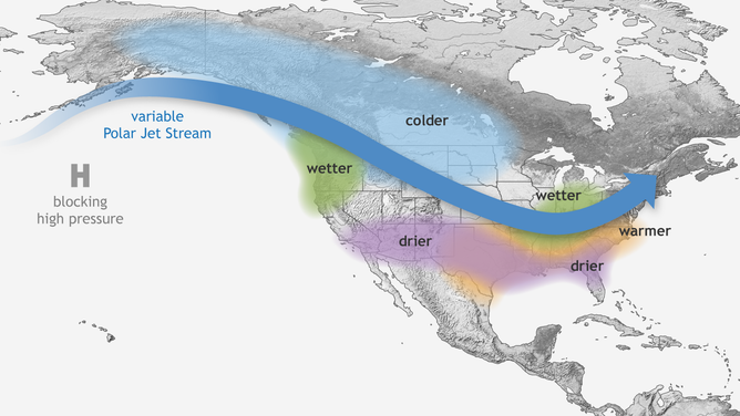
Typical La Nina Pattern
(NOAA's Climate.gov)
NOAA's Climate Prediction Center gives a 77% chance La Niña conditions will last through spring, then give slightly favorable chances (56%) of neutral conditions taking hold in late spring into summer. Neutral conditions are when the central Pacific Ocean temperatures are near average, and the influencing effects of ENSO are more limited.
Confidence in the forecast beyond this spring is relatively low, as ENSO forecast models have a difficult time seeing past spring due to what's known as the "spring predictability barrier."
However, tropical forecasters will look to get clues about the ENSO phases as La Niña years tend to bring more active tropical seasons while El Niño years tend to have more suppressed tropical seasons. As it stands now, neutral conditions (which, again, don't have as much impact on global weather patterns) are the favored conditions in the tropical peak season of late summer and early autumn at about 45-50%, with odds of a stubborn La Niña around 30% and a flip to El Niño at about 15-20%
Colorado State University will issue its annual hurricane forecast on April 7.
In the meantime, February has taken a break from the typical La Niña pattern with dry conditions across the Northwest and cold spells along the southeast and east. Still, long-range indications are for La Niña conditions to return later in February and March.