Double dip: La Niña now given over 90% chance of being in charge this winter
Of the past 12 La Niña winters, eight have featured a "double dip"
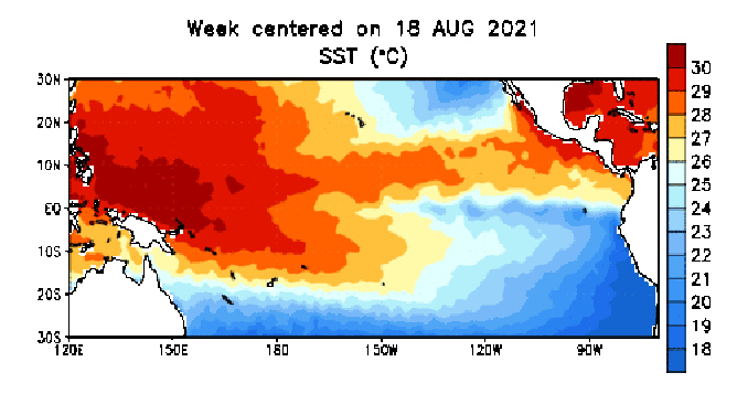
This animation shows how average sea-surface temperature anomalies (Celsius) have changed from mid-August to early November. Anomalies, or departures from average, are computed with respect to the 1991-2020 base period weekly averages.
(NOAA/CPC)
La Niña is likely to continue through the winter for the second consecutive year, according to an updated outlook issued Thursday by NOAA's Climate Prediction Center.
The CPC said La Niña strengthened over the past month, with cooler-than-average sea-surface temperatures evident across most of the equatorial Pacific Ocean.
The most recent forecasts on the El Niño/La Niña cycle indicate there is now a 92% chance that La Niña conditions will dominate during the three-month climatological winter from December 2021 through February 2022. That's a slight increase from the previous outlook last month that predicted an 87% chance of La Niña this winter.
This means it's essentially a slam dunk that we're about to go through a second straight winter with La Niña in charge.
Forecasters at the CPC have issued a "La Niña Advisory," which means La Niña conditions have been observed and are expected to continue. In this case, they could continue into the spring, as there's a 50% chance of La Niña conditions during the March-to-May period.
What is La Niña?
La Niña is part of a 5- to 7-year cycle known as the El Niño Southern Oscillation, or ENSO, generated from a change in water temperatures in the central and eastern equatorial Pacific Ocean.
When sea-surface temperatures drop to 0.9 degrees Fahrenheit (0.5 degrees Celsius) below average or lower, it's considered La Niña. When water temperatures rise to 0.9 degrees Fahrenheit above average or higher, it is known as El Niño. When waters are between 0.9 degrees Fahrenheit above and below average, neither El Niño nor La Niña is in place, so it's considered "neutral" conditions.
Researchers have found these changes in ocean temperatures have a cascading effect on weather conditions across the tropics in the Pacific Ocean, which, in turn, has a profound effect on global weather patterns by altering the positions of jet streams.
In the United States, La Niña winters generally bring cooler, wetter conditions to the North and milder, drier conditions to the South. It can keep a drought going in the Southwest, while the Pacific Northwest basks in an above-average mountain snowpack.
The Northern Plains are usually in for a colder-than-average winter, while the Great Lakes region tends to lean on the wetter side. The Southeast and Deep South westward into Texas usually end up with a mild and dry winter.
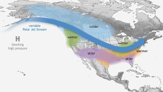
Typical wintertime impacts of La Niña across the United States.
(NOAA)
As you might surmise, the opposite part of the cycle, the warm-phase El Niño, tends to bring the reverse patterns.
El Niño winters are usually warm and mild across the northern U.S. and very wet across the South.
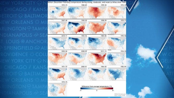
Maps showing how temperatures fared across the United States during La Niña winters since 1950.
(NOAA)
Globally, La Niña winters can cause drought in South America, affect the monsoon season in the Indian Ocean and supercharge the Atlantic hurricane season. The record-shattering hurricane season of 2020 coincided with La Niña conditions during the winter of 2020-21.
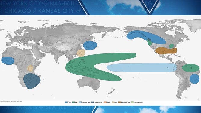
Typical wintertime impacts of La Niña across the world.
(NOAA)
Hey, that's right: Didn't we just do this last winter?
Indeed, this is shaping up to be what forecasters call a "double-dip" La Niña in which the equatorial Pacific warms out of La Niña conditions after a winter, then returns to La Niña in time for the following winter.
Traditionally, we think of the ENSO cycle progressing over a 5- to 7-year period from El Niño to neutral to La Niña winters, then reversing back through neutral to another El Niño winter and starting the cycle over again.
But sometimes, La Niña decides to give it a second go, and in fact, of the past 12 La Niña winters, eight have featured a double dip.