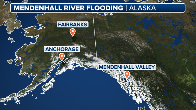
Record glacial outburst flooding rocks parts of Alaska's capital as residents seek higher ground
According to the National Weather Service (NWS) office in Juneau, the Mendenhall River crested at 16.65 feet – which now makes it the largest glacial lake outburst flooding event ever recorded.
Watch: National Weather Service flies over Alaska's Mendenhall Glacier before outburst
A video provided by the National Weather Service office in Juneau, Alaska, shows scientists flying above the Mendenhall Glacier on Tuesday, Aug. 12, before the glacial lake outburst flooding.
The all clear has been given in Juneau after the record glacial lake outburst flood event. Coverage continues by clicking here.
JUNEAU, Alaska - The Mendenhall River near Alaska’s capital of Juneau crested at a record level Wednesday morning after a glacial outburst sent water filled with debris rushing downstream and into communities, forcing residents to evacuate and seek higher ground.
According to the National Weather Service (NWS) office in Juneau, the Mendenhall River crested at 16.65 feet – which makes this event the largest glacial lake outburst flooding event on record.
Last year’s event, which took place between Aug. 3 and Aug. 6, was the previous record when the river crested at 15.99 feet.
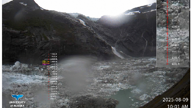
This animated image shows water levels dropping within Suicide Basin in Alaska after a glacial lake outburst between Aug. 9 through Aug. 12.
(NOAA)
Before the flooding took place, officials had recommended people living within the 17-foot lake-level inundation zone evacuate to higher ground until the water fully receded and an "All Clear" message was sent out via the Wireless Emergency Alert system.
The Red Cross also opened a shelter at a local gymnasium where evacuated residents could stay until conditions improved.
Several facilities had also been closed because of the anticipated flooding, including the Mendenhall Valley Public Library, Diamond Park Field House, Diamond Park Aquatic Center and all nearby fields.
Travel, too, was impacted, as flooding forced the closure of several roads in the area, including the Mendenhall Loop Road (Back Loop Bridge).
Officials said that closure would remain in effect until water levels dropped to below 12 feet and engineers could complete a safety inspection.
In addition, the Federal Aviation Administration (FAA) issued a Temporary Flight Restriction (TFR) around the area.
"This TFR creates controlled airspace to ensure safe aerial operations for geo-hazard monitoring, flood response, and potential evacuations," the Alaska Department of Transportation & Public Facilities said.
DOWNLOAD THE FREE FOX WEATHER APP
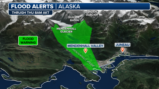
This graphic shows the Flood Warning in effect in parts of Juneau, Alaska, following a glacial lake outburst.
(FOX Weather)
The NWS issued a Flood Warning for the Mendenhall River ahead of the anticipated flooding.
The NWS had forecast the river to crest anywhere between 16.25 feet and 16.76 feet, and believed it would be closer to the higher end of that forecast.
While water on its own is dangerous, officials also warned of debris in the water that could make the situation even worse.
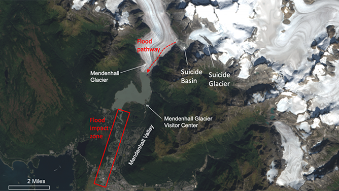
This image provided by the National Weather Service (NWS) office in Juneau, Alaska, shows locations likely to be impacted by glacial lake outburst flooding.
(National Weather Service / FOX Weather)
The NWS said mariners should be aware that numerous trees and other debris were in the water and were being washed downstream.
"There is a lot of debris in the river. Please stay away from the river. It’s very dangerous right now," said Andrew Park, a meteorologist at the NWS office in Juneau said. "If you get in that water, you’re not going to make it out of there. So, please, remain away from the river."
This graphic shows where the glacial lake outburst flooding is occurring in the Mendenhall Valley in Alaska.
(FOX Weather)
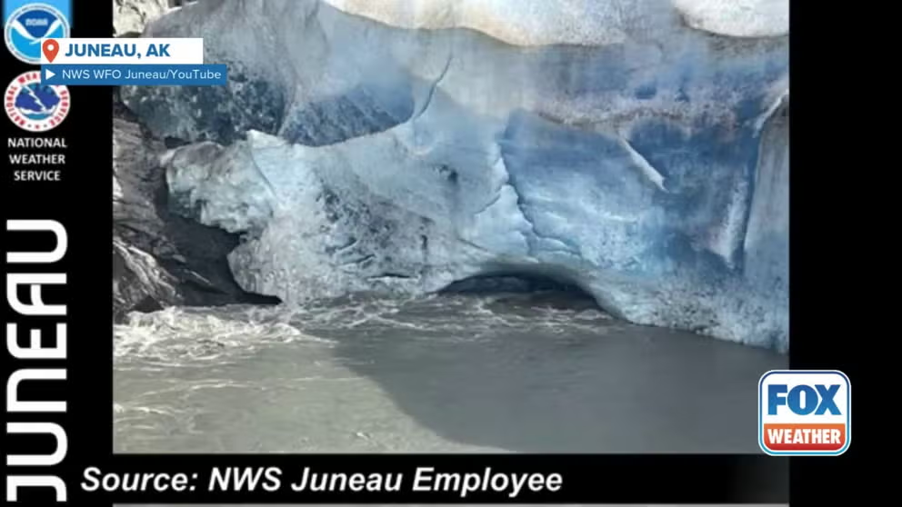
Suicide Basin is a side basin of the Mendenhall Glacier above Juneau. Since 2011, the NWS said Suicide Basin has released glacial lake outburst floods that caused inundation along Mendenhall Lake and River annually. Prior to this event, the last release occurred on Oct. 20, 2024.
What is a glacial lake outburst flood?
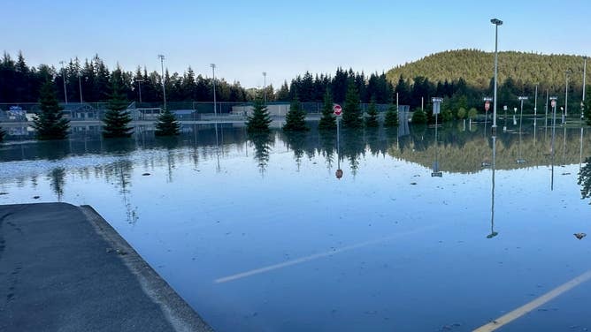
FILE - This photo shows a flooded parking lot in Alaska after glacial lake outburst flooding.
(City and Borough of Juneau / FOX Weather)
A glacial lake outburst flood (GLOF) isn't like the typical type of flooding that occurs from torrential rain and thunderstorms.
According to the USGS, glacial lakes form in small side valleys that have lost ice and then become dammed by the glacier in the main valley or dammed by rocks and debris.
Over time, as the ice-free basins fill with water, the USGS said, lakes reach a breaking point where water pressure opens up a drain underneath the glacier that releases the water downstream, which can result in a GLOF.
"These events are unpredictable and have caused significant loss of life and infrastructure worldwide," the USGS said. "Furthermore, it is unclear how these lake hazards may change as temperatures rise and glaciers continue to melt."