Heavy lake-effect snowstorm could drop a foot of snow in Buffalo, New York, later this week
The National Weather Service said there's a chance of thundersnow within about 20 miles of the Lake Erie shores
Significant lake-effect snowstorm expected in Buffalo, NY, later this week
A significant lake-effect snowstorm is expected in Buffalo, New York, later this week.
BUFFALO, N.Y. – Residents of western New York are bracing for a heavy lake-effect snowstorm that forecasters say could drop a foot of snow in parts of the Buffalo metro area Wednesday evening through Thursday evening.
The National Weather Service has issued Winter Storm Watches northeast of lakes Erie and Ontario, where total snow accumulations of 9 inches or more are possible in the most persistent lake snows. This includes the cities of Buffalo and Watertown, New York.
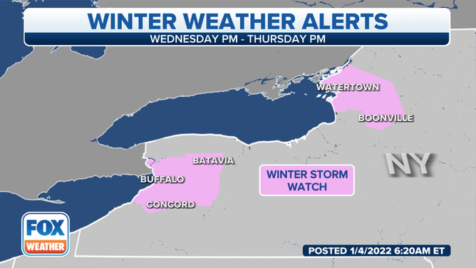
Winter Storm Watches are in effect northeast of lakes Erie and Ontario.
(FOX Weather)
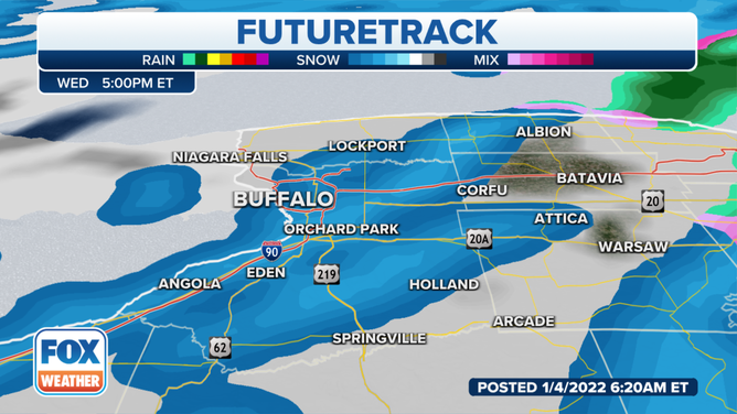
Beginning Wednesday evening, weather conditions will support "a single plume of moderate to occasionally heavy lake snow that will extend across the Buffalo metro area," NWS-Buffalo meteorologists wrote in a forecast discussion Tuesday morning. "Snowfall rates will range from a half to 1.5 inches an hour...and this should promote overnight snowfall amounts up to 9 inches from the Buffalo metro area to near Corfu, with lesser amounts extending northeast to western Monroe County."
(FOX Weather)
Additionally, the NWS said there's a chance of thundersnow within about 20 miles of the Lake Erie shores.
THUNDERSNOW: WHAT CAUSES LIGHTNING AND THUNDER DURING A SNOWSTORM?
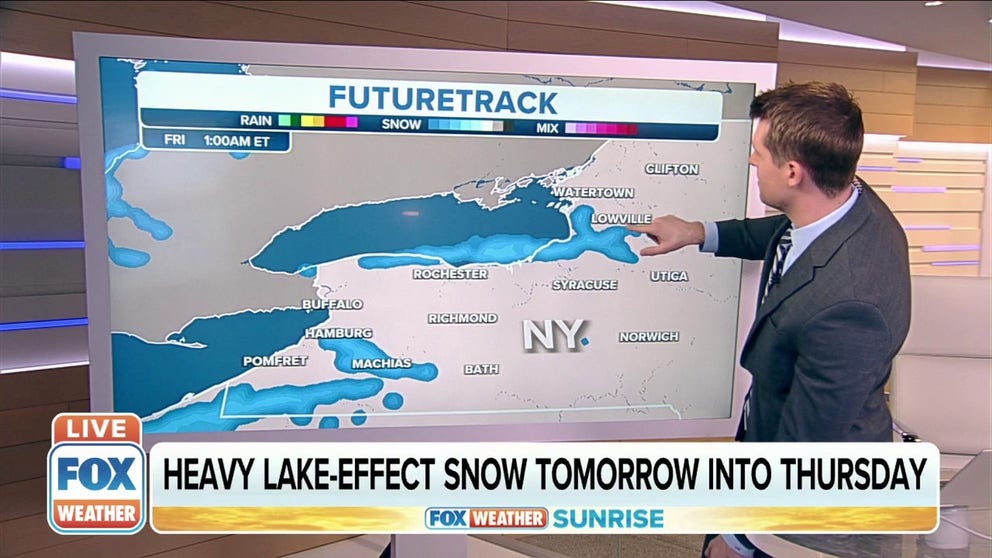
The band of lake-effect snow is predicted to remain nearly stationary into Thursday. That could bring an additional 5 to 8 inches during the day for Buffalo and its immediate southern suburbs and northeastward to Darien and Batavia, New York.
(FOX Weather)
A lake-effect snowband will also develop Wednesday night northeast of Lake Ontario and target areas near and just south of Watertown, New York. Snowfall rates will be on the order of a half-inch to an inch per hour. Overnight snowfall amounts in these areas are forecast to top out around 6 or 7 inches, according to the NWS.
The snow could turn a bit heavier on Thursday, with snowfall rates reaching an inch or more per hour between Watertown and the northern slopes of the Tug Hill Plateau. Several more inches of snow are expected to pile up during the day in the most persistent lake snows.
The NWS said there's a 100% chance at least 8 inches of snow will pile up in both Buffalo and Watertown.
Computer forecast models indicate 8 to 12 inches of snow will fall in Buffalo and Watertown through Thursday evening. However, a foot or more is likely to accumulate just to the south of those cities.
Wind gusts around 30 mph could also create areas of blowing and drifting snow, which means visibility might drop to near zero at times.
WHAT YOU SHOULD KNOW ABOUT BLOWING, DRIFTING SNOW
Travel will be significantly impacted on portions of the New York State Thruway (Interstate 90) between Buffalo and Rochester, New York, and also on Interstate 81 between Watertown and Syracuse, New York.
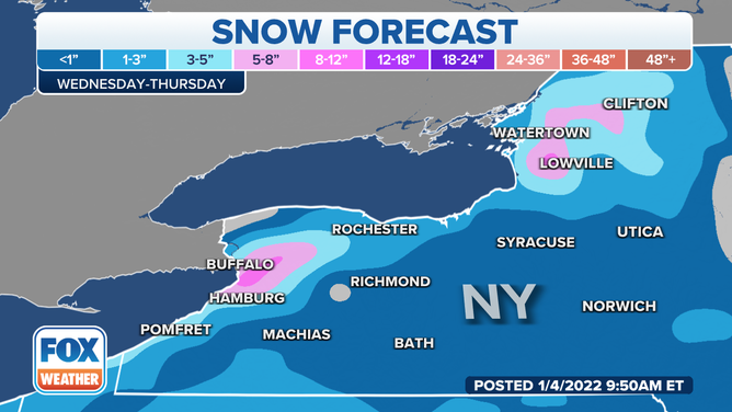
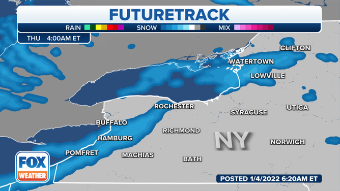
Snow forecast through Thursday, Jan. 6, 2022.
(FOX Weather)