Persistent stormy weather pattern soaks parts of central, southern US. Here's when it will end
June and July are America's most active months for damaging thunderstorm wind events. According to NOAA’s Storm Prediction Center, an average of 3,187 reports of damaging winds are received each June, followed by another 3,109 reports every July.
Weekend weather outlook
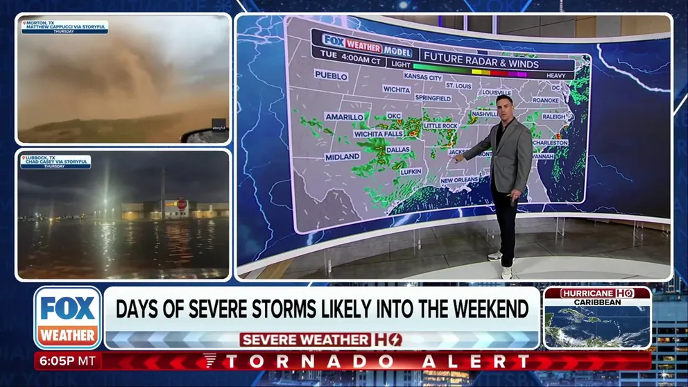
FOX Weather meteorologist Steve Bender has a look at who will see storms over the weekend.
If you're not a fan of the recent summer days, you might want to try to get used to them as the current weather pattern dominating much of the U.S. isn’t going anywhere anytime soon.
A strong and persistent Atlantic ridge is causing a traffic jam of sorts across parts of the central and southern U.S. allowing for daily thunderstorm activity.
As a result, widespread rainfall and decreased temperatures have become a near-daily occurrence for millions of Americans.
On any given day recently, anywhere from 40 to 90 million Americans are under the threat of severe thunderstorms, with the primary risks being hail, damaging winds and flooding.
Pieces of energy typically originate over the eastern slopes of the Rockies or across the Plains before gradually pushing eastward.
![Map of recent severe weather risks]() Image 1 of 2
Image 1 of 2Map of recent severe weather risks ( )
![Atlantic ridge halts activity]() Image 2 of 2
Image 2 of 2Atlantic ridge halts activity ( )


For instance, depending on the day's set up, storms might begin over Texas and work eastward to impact Dallas, Little Rock and Atlanta, while the preceding day may affect areas miles north to include Oklahoma City, Memphis and Nashville.
Communities around Tulsa, Oklahoma, and Paducah, Kentucky are off to their wettest starts to meteorological summer ever, while areas not too far away haven’t seen a drop, such as along the western Gulf Coast.
WATCH: SUPERCELL CUTS PATH THROUGH 2 STATES, PRODUCING TORNADOES LIVE ON FOX WEATHER
The stormy pattern has had the effect of keeping temperatures below what’s typical for early summer.
Widespread cloud cover and frequent rainfall have limited daytime highs, keeping unbearable heat waves at bay, at least for now.
While the weather map is used to depict record highs, temperatures have been on the order of 2 to 4 degrees below average.
June and July are America's most active months for damaging thunderstorm wind events. According to NOAA’s Storm Prediction Center, an average of 3,187 reports of damaging winds are received each June, followed by another 3,109 reports every July.
WHAT IS A MESOSCALE CONVECTIVE SYSTEM?
Here’s what is coming next?
Changes may be on the way by late month as a ridge of high pressure over the Plains becomes the driving force of weather events.
Instead of training over the South, future storm activity may begin tracking farther north and east, spreading into the Northern Plains, the Midwest and portions of the Great Lakes – a more classic summertime pattern.
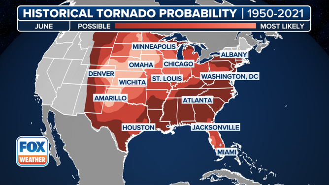
This graphic shows the historic tornado probability in June.
(FOX Weather)
The pattern will feature mesoscale convective systems, which could travel hundreds of miles across the northern tier of the country.
The adjustment of the weather features could also allow for the start of the Southwest’s monsoon season, with increased moisture entering regions such as Arizona and New Mexico, depending on the location of the ridge.
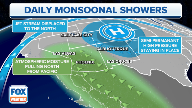
Daily Monsoonal Showers Setup
(FOX Weather)
Meanwhile, areas underneath the core of the high pressure from Texas into the Mississippi Valley will heat up with triple-digit heat becoming all the more likely.
Despite signs of the upcoming change, the current wet weather pattern is expected to linger for at least another week or two, leading to increased flooding risks for areas that are impacted by the daily downpours.