Watch: Supercell cuts path through 2 states, producing tornadoes live on FOX Weather
April, May and June are known for being active months for severe weather across the Central U.S. While May is the peak month for tornado activity, June still sees its fair share of tornadic events.
Fox Weather Storm Tracker captures tornado roaring across Texas
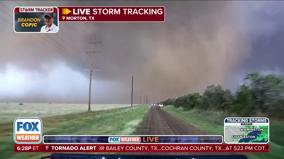
FOX Weather Exclusive Storm Tracker Brandon Copic captures the moment a confirmed tornado moved across parts of rural Texas.
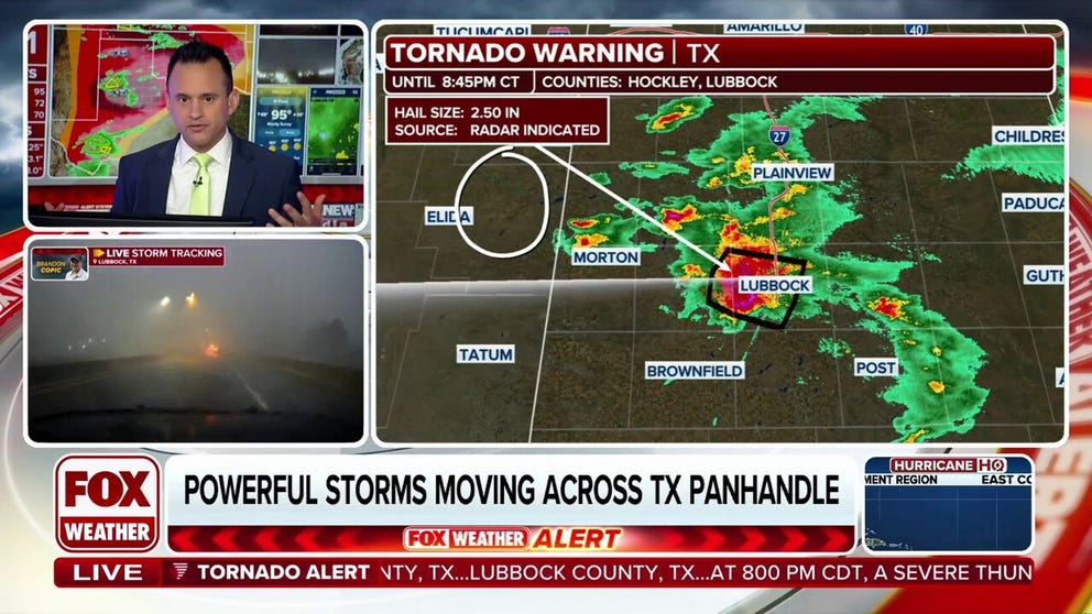
LUBBOCK, Texas – A powerful supercell thunderstorm trekked across eastern New Mexico and West Texas on Thursday, producing tornadoes, large hail, damaging winds and flash flooding.
This single storm spawned an astonishing 19 tornadoes, the FOX Forecast Center said, causing significant damage that ranged from mobile homes being overturned to roofs being ripped off buildings.
The storm traveled more than 80 miles, producing its first tornadoes around Causey, New Mexico, and not giving up before reaching Lubbock, Texas, during the evening hours, where most of the impacts were felt.
The thunderstorm was one of several that developed across the Southern Plains, where the Storm Prediction Center had issued Severe Thunderstorm and Tornado Watches earlier in the day.
Despite the potential for showers and thunderstorms across much of the Lower 48, the most dangerous activity was centered over the Plains and West Texas.
FOX Weather Exclusive Storm Tracker Brandon Copic intercepts a tornado touching down in Shallowater, Texas on June 5, 2025.
(FOX Weather)
PHOENIX HAS ALREADY HIT 100 DEGREES. WHAT DOES THIS EARLY HEAT MEAN FOR SUMMER?
The supercell that storm chasers had their eye on was able to break through the atmospheric cap and produce its first tornado not far from the New Mexico-Texas line.
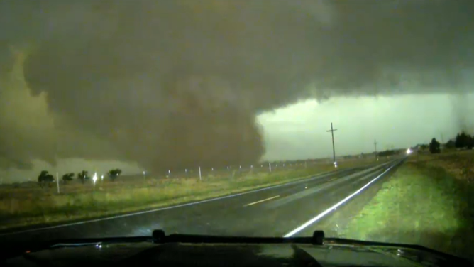
FOX Weather Exclusive Storm Tracker Brandon Copic was able to take video of the cell, which produced a rope-like, dusty twister out in what many would proverbially call ‘the middle of nowhere.’
Outside of possibly a small outhouse or a utility line, no damage was reported in much of eastern New Mexico, but the storm wasn’t done.
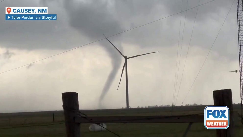
A funnel cloud was observed in Causey, New Mexico, amid a Tornado Warning
A funnel cloud was spotted swirling behind wind turbines in New Mexico, before quickly dissipating. The National Weather Service issued a tornado watch for the area this evening.
As it moved into West Texas, atmospheric conditions allowed the cell to grow in size and intensity, ultimately producing what may have been the strongest tornado of the event.
Video captured dust and anything not bolted down in the rural countryside being picked up by the wedge-shaped vortex.
Fortunately, again, much of the track of the storm remained over sparsely populated areas, but its sheer size did not prevent the National Weather Service from issuing warnings with headlines such as "Particularly Dangerous Situation."
Despite the storm’s longevity, the supercell didn't conclude after impacting areas around the town of Morton and still had the largest city in its path – Lubbock, Texas - which is about 50 miles away.
Tornado-generating supercell sweeps through two states
A supercell thunderstorm produced numerous tornadoes from eastern New Mexico into West Texas on Thursday.
"I've been watching this storm since I got into work several hours ago… People were posting videos of tornadoes that it was producing, and it's been just moving ever so slowly from west to east, and unfortunately it's got a bullseye right on Lubbock right now," FOX Weather meteorologist Ari Sarsalari said while tracking the supercell.
As the tornado approached the region of more than 250,000 residents, it became rain-wrapped, causing additional dangers, as vortexes are more difficult to track when obscured.
At one point, residents in the area reported twin tornadoes, in addition to damaging hail, hurricane-force wind gusts and flooding rains.
At Texas Tech University, students were urged to seek shelter and stay away from windows as the storm approached campus.
The combination of hail and heavy rainfall triggered dangerous flash flooding, with some roads turning into streams and rivers.
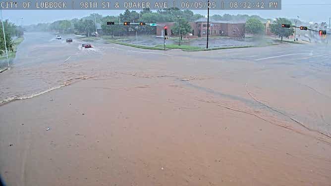
Flash flooding in Lubbock, Texas on 6/5/2025
(City of Lubbock / FOX Weather)
Videos from traffic cameras showed vehicles wading through deep water – situations that forecasters always warn can be deadly and drivers should try to avoid.
Search and rescue crews worked late into Thursday night to assist stranded drivers and search for potential storm victims, but emergency managers only reported one injury as of Thursday evening.
Several structures appeared to have significant damage from either a tornado or straight-line winds that were estimated to have been in excess of 80 mph and thousands were without power.

Hail comparison over West Lubbock, Texas 6/5/2025.
(@myprojectpluto / FOX Weather)
Following the damage in Lubbock, the cell appeared to stop producing tornadoes, but it remained a dangerous storm, with the potential of softball-sized hail and gusty winds into the heart of the Lone Star State.
The cell was still heading eastward as of late Thursday evening; however, it appeared the worst of the weather would spare the city of Abilene and stay north of Interstate 20.
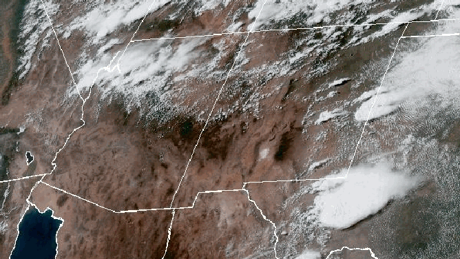
GOES Satellite animation of supercell thunderstorms moving through New Mexico and Texas.
(NOAA)