Thunderstorms slam I-95 corridor, soaking evening commuters as flood threat spans Appalachians
Forecasters reminded residents that just 6 inches of moving water can knock an adult off their feet, while a foot of floodwater can cause most vehicles to stall and even be carried away.

Thunderstorms inundate Lawrence, Massachusetts
Thunderstorms inundated Lawrence, Massachusetts and caused road flooding Wednesday evening.
NEW YORK – Showers and thunderstorms pushed through the Interstate 95 corridor Wednesday, producing heavy rainfall and localized flash flooding from the mid-Atlantic to the Northeast.
The severe weather soaked evening commuters and knocked out power across parts of the regions. The storms were associated with a nearly stationary cold front draped across the region, which allowed for an influx of Gulf moisture to stream northward.
According to FindEnergy.com, more than 9,500 customers remained without power as of Thursday morning in New York, concentrated mostly in the mid-Hudson Valley, and some 5,000 customers in Massachusetts were still powerless, mostly in Norfolk County.
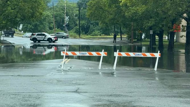
![Scranton police block flooded intersections during severe thunderstorms Wednesday, August 14, 2025.]() Image 1 of 2
Image 1 of 2Scranton police block flooded intersections during severe thunderstorms Wednesday, August 14, 2025. (Scranton Police Department - City of Scranton, PA/Facebook)
![Scranton police block flooded intersections during severe thunderstorms Wednesday, August 14, 2025.]() Image 2 of 2
Image 2 of 2Scranton police block flooded intersections during severe thunderstorms Wednesday, August 14, 2025. (Scranton Police Department - City of Scranton, PA/Facebook)

Localized road flooding was seen stranding drivers in low-lying areas in Lawrence, Massachusetts Wednesday night.
Police in Scranton, Pennsylvania had to block off flooded intersections as water quickly rose during intense thunderstorms.
Rainfall rates of 1-3 inches of rain per hour were possible in the strongest cells.
Areas around higher terrain, including the Poconos, the Catskills and the Appalachian Mountains, were especially vulnerable to flash flooding, as runoff can occur more quickly in steep landscapes.

Severe storms whip through northeastern Pennsylvania
Severe storms whipped through northeastern Pennsylvania Wednesday evening.
During the height of the activity, significant travel delays were reported across the region.
While storms snarled travel in New York City, the rain helped put a small dent in what has been one of its driest summers in the past 15 years.
New York City only picked up 0.71 inches of rain and is currently about five inches below its average year-to-date precipitation.

Strong thunderstorm sweeps through Brooklyn, New York
A strong thunderstorm swept through Brooklyn, New York on Wednesday during the evening rush. New York City is currently about five inches below its average year-to-date precipitation.
While the East Coast storms were causing travel headaches, Tennessee was still reeling from deadly flooding that took place on Tuesday evening.
The deluge swamped roads, inundated neighborhoods and forced numerous water rescues, including along Interstate 24, which was shut down for an extended period.
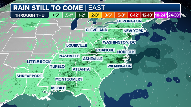
Forecast rainfall map
(FOX Weather)
JELLYFISH SWARM FORCES SHUTDOWN OF FRENCH NUCLEAR POWER PLANT
Forecasters stress that just 6 inches of moving water can knock an adult off their feet, while a foot of floodwater is enough to stall and even sweep away some vehicles.
The combination of the slow-moving frontal system and abundant tropical moisture created an ideal setup for torrential rainfall, a pattern that the FOX Forecast Center expects to linger into Thursday.
After the front essentially rains itself out, conditions are expected to turn hotter and drier, with temperatures soaring back into the 90s for much of the Southeast and mid-Atlantic into the weekend.

Heavy rain swamps Chattanooga, Tennessee
Over 6 inches of rain fell in Chattanooga, Tennessee on Tuesday, the city's second-wettest day on record after thunderstorms dropped heavy rain ahead of a cold-front that moved through the region.