4 killed by historic flooding in east Tennessee as Chattanooga faces continued rain threat
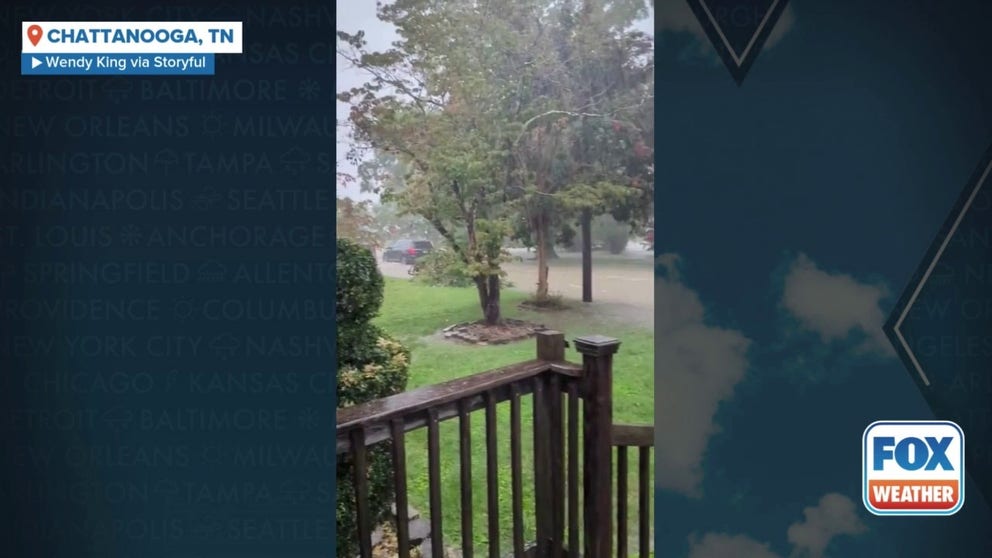
More than 6 inches of rain fell in Chattanooga, Tennessee, on Tuesday, according to the National Weather Service, the city's second-wettest day on record, as thunderstorms dropped heavy rain ahead of a cold-front that moved through the region.

East Tennessee cleans up after historic flooding ahead of more rain
There is a plausible scenario that a strong Hurricane Erin's center will track close enough to Eastern North Carolina and New England to do more than just brush the coast next Wednesday and Thursday. FOX News Multimedia Reporter Asher Redd has the latest.
CHATTANOOGA, Tenn. – Four people are dead after severe weather and flooding slammed the Chattanooga area in Tennessee on Tuesday night and Wednesday morning.
Chattanooga fire officials said they found the body that matched the description of a missing man who was swept away by floodwaters off East Brainerd Road during the height of the storm Tuesday night.
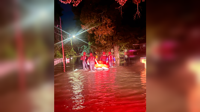
![CHATTANOOGA, TN — Swift water rescue teams perform water rescues late Tuesday evening after near-record flooding.]() Image 1 of 7
Image 1 of 7Swift water rescue teams performed water rescues late Tuesday evening after near-record flooding in Hamilton County, Tennessee. (@hcsotn/X)
![CHATTANOOGA, TN — Swift water rescue teams perform water rescues late Tuesday evening after near-record flooding.]() Image 2 of 7
Image 2 of 7Swift water rescue teams performed water rescues late Tuesday evening after near-record flooding in Hamilton County, Tennessee. (@hcsotn/X)
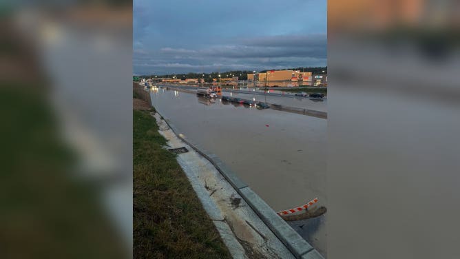
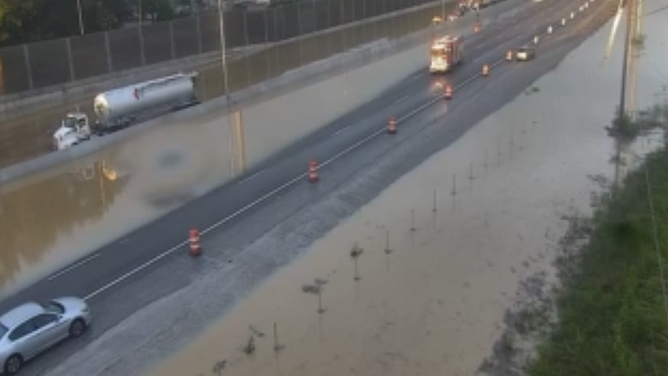
![Interstate 24 was closed Tuesday night between Interstate 75 and US 27 in Hamilton County, Tennessee due to widespread flooding.]() Image 3 of 7
Image 3 of 7Interstate 24 was closed Tuesday night between Interstate 75 and US 27 in Hamilton County, Tennessee due to widespread flooding. (MyTDOT)
![nterstate 24 was closed Tuesday night between Interstate 75 and US 27 in Hamilton County, Tennessee due to widespread flooding.]() Image 4 of 7
Image 4 of 7nterstate 24 was closed Tuesday night between Interstate 75 and US 27 in Hamilton County, Tennessee due to widespread flooding. (MyTDOT)
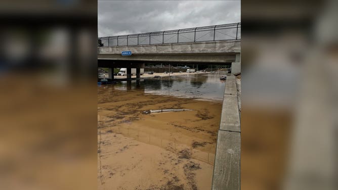
![Flooding in Chattanooga, TN on 8/12/2025]() Image 5 of 7
Image 5 of 7Flooding in Chattanooga, TN on 8/12/2025 (Chattanooga, TN)
![Flooding in Chattanooga, TN on 8/12/2025.]() Image 6 of 7
Image 6 of 7Flooding in Chattanooga, TN on 8/12/2025. (TDOT)
![Flooding in Chattanooga, TN on 8/12/2025]() Image 7 of 7
Image 7 of 7Flooding in Chattanooga, TN on 8/12/2025 (TDOT)


The man was trying to move around barricades, Chattanooga Mayor Tim Kelly said at a Wednesday news conference.
"(He) unfortunately, unwisely tried to maneuver around fire department barricades and was swept away by a stream," Kelly said.
The victim has not been identified.
Saturated ground from heavy rain also caused a large tree to fall on a car in the 1100 block of South Moore Road in East Ridge early Wednesday morning, killing two adults and a child, according to the Hamilton County Office of Emergency Management and Homeland Security.
RECORD GLACIAL OUTBURST FLOODING ROCKS PARTS OF ALASKA'S CAPITAL AS RESIDENTS SEEK HIGHER GROUND

Two people were treated after a tree fell on their vehicle Thursday morning, Aug. 14, 2025.
(Hamilton County EMS/Facebook)
Hamilton County EMS said another tree fell on a vehicle Thursday morning, causing an accident, underscoring how saturated soils remained. Two victims were successfully extricated and were taken to the hospital for evaluation, officials said.
While the worst of the rain is over, the same cold front that was responsible for Tuesday's inundation will bring a final round of rain Thursday.

Car and trash can spin in whirlpool on I-24.
(Stephany Thomas via Storyful / FOX Weather)
Weston Wamp, the mayor of Hamilton County, Tennessee, declared a state of emergency on Tuesday evening as emergency workers conducted water rescues and floodwaters inundated dozens of roads.
Wamp said Wednesday that he met with Office of Emergency Management officials and East Ridge first responders to survey flood damage and to discuss the next steps in response and recovery.
More than 6 inches of rain fell in Chattanooga on Tuesday, according to the National Weather Service, the city's second-wettest day on record, as thunderstorms dropped heavy rain ahead of a cold-front that moved through the region.

Interstate 24 was closed Tuesday night between Interstate 75 and US 27 in Hamilton County, Tennessee due to widespread flooding.
(FOX Weather)
The Chattanooga Fire Department reported conducting 35 rescues, including pulling stranded drivers from vehicles and assisting residents trapped inside homes as water levels rose rapidly.
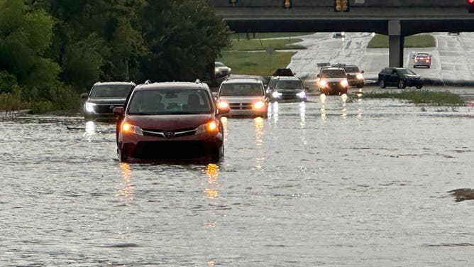
One of the hardest-hit areas appeared to be along Interstate 24 southeast of Chattanooga, where floodwaters several feet deep forced crews to close the highway in both directions.
Emergency managers said at least one storm shelter was opened at a local recreation center to assist residents displaced by the flooding.
Heavy rain swamps Chattanooga, Tennessee
Over 6 inches of rain fell in Chattanooga, Tennessee on Tuesday, the city's second-wettest day on record after thunderstorms dropped heavy rain ahead of a cold-front that moved through the region.
"Turn around, don’t drown when encountering flooded roads," the NWS said in its Flash Flood Warning bulletin. "Most flood deaths occur in vehicles. Move to higher ground now. Act quickly to protect your life."
First responders urged drivers to avoid flooded roadways, especially during nightfall when water depths are harder to gauge.
Just 6 inches of moving water can knock an adult off their feet, while a foot of floodwater can cause most vehicles to stall and even be carried away.
The FOX Forecast Center attributed the deluge to abundant moisture streaming northward from the Gulf, combined with the hilly terrain of the southern Appalachian region, which can enhance convection.
KNOW YOUR FLOOD TERMINOLOGY: WHAT FLOOD WATCHES, WARNINGS AND EMERGENCIES REALLY MEAN
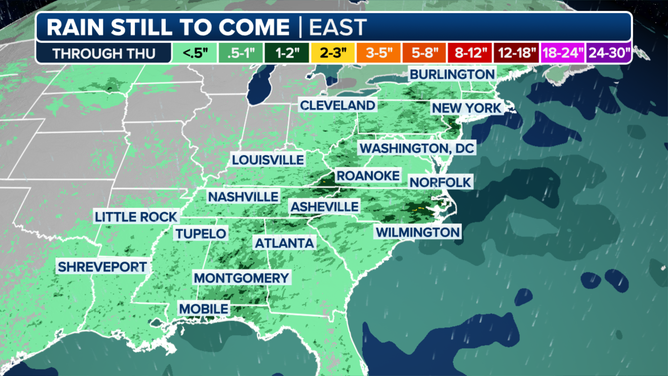
Forecast rainfall map
(FOX Weather)
The storms responsible for Tuesday and Wednesday's flooding were part of a broader unsettled pattern across the Southeast that is expected to persist for another day.
More periods of scattered showers and storms are expected to return on Thursday, according to the NWS office in Morristown.
Once the precipitation departs, forecasters expect temperatures to climb, with highs reaching the 90s and heat indexes approaching 100 degrees.