Winter Storm Warning issued for Denver, Boulder as snowstorm could dump foot of snow on Front Range
The heaviest snow is likely to fall on Thursday. But the storm will be affecting both the Wednesday evening and Thursday morning commutes and could possibly bring the highest snow totals of the season.
Winter Storm Warning issued for Denver metro ahead of snowstorm
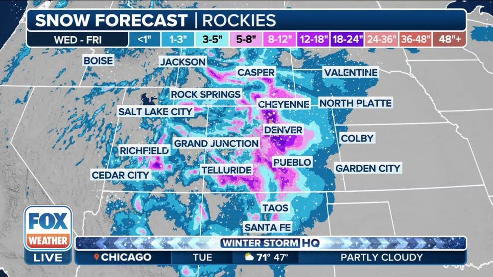
Denver is expecting between 8-12" of snowfall through Friday morning.
DENVER – A Winter Storm Warning has been issued for the Denver and Boulder areas as a potent storm system moving into Colorado and the Front Range from the Northwest is expected to dump heavy snow across the region that will likely lead to numerous travel issues, especially along the Interstate 25 and Interstate 70 urban corridors.
Back-to-back storms are bringing rain and snow to the Pacific Northwest, and forecasters have been eyeing the second system as being the most impactful storm for Colorado and Utah in the Intermountain West.
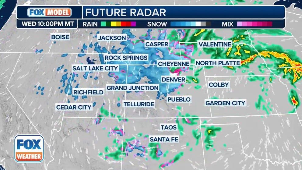
Watch: Exclusive FOX Model Futuretrack shows winter storm impacting Rockies, including Denver
The exclusive FOX Model Futuretrack shows a powerful winter storm impacting the Rockies, including cities such as Denver and Boulder in Colorado.
The FOX Forecast Center is tracking the potential for 8-12 inches of snow for the Denver metro, with more than a foot possible in Boulder.
In the mountains west of the I-25 urban corridor, snow accumulations between 1 and 2 feet, with locally up to 3 feet, are possible through Thursday with winds gusting up to 35 mph.
With heavy snow in the forecast, winter weather alerts are in place across the region from Idaho and northeastern Nevada to Wyoming, Utah and Colorado.

(FOX Weather)
Winter Storm Watches extend from Cheyenne in Wyoming south along I-25 through Estes Park, Denver and Trinidad in Colorado.
Winter Weather Advisories are in effect for Aspen, Vail and Buena Vista in Colorado.

(FOX Weather)
After a warmer and dry start to the week with high temperatures for Denver in the mid-60s, the winter storm will move in, dropping temperatures to near or below freezing on Wednesday night.
6 BASIC STEPS FOR PROPERLY MEASURING SNOW
The storm is expected to create dangerous travel conditions along interstates 25, 70 and 80.

(FOX Weather)
Travel on I-25 could be impacted by periods of heavy snow, causing low visibility on Thursday. Drivers should make sure their vehicles are winter-ready.
TRAVELING THIS WINTER? HERE’S WHAT TO KEEP IN YOUR CAR IN CASE YOU GET STUCK
The heaviest snow is likely to fall on Thursday. But the storm will be affecting both the Wednesday evening and Thursday morning commutes, and could possibly bring the highest snow totals of the season.
Denver far behind on snow, but March is Mile High City's snowiest month
This round of snow could help Colorado make up its snowpack.
Denver has picked up less than 30 inches of snow this winter, far below the typical 52 inches it would receive in an average season. Last week, Denver saw 0.3 inches of snow, while areas in the Colorado Plains near Akron received more than 5 inches.

(FOX Weather)
March is typically the snowiest month of the year in Denver, so it's not uncommon for the Mile High City's biggest snowstorms to occur this late in the season.
The last time Denver received at least 6 inches of snow in a single day was Dec. 28, 2022, when 6.4 inches piled up. It's been nearly three years (March 14, 2021) since Denver saw more than 10 inches of snow in a day during a winter storm.