Cold air invades US to start November
Many cities will see their first freeze of the season, including Chicago and Kansas City
Cold air invades US to start November
Cold air invades US to start November.
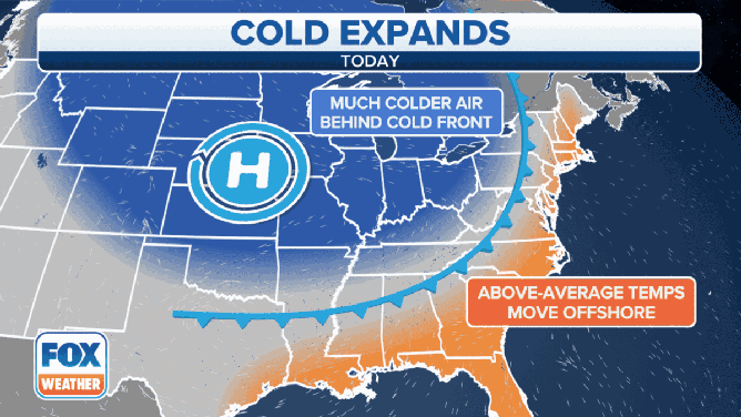
The final month of fall will begin on a chilly note as cold air invades the central United States on Monday and sweeps across much of the nation through the week ahead.
Many cities east of the Mississippi River endured one of their warmest Octobers on record, but that mild air will now be replaced by the coldest air so far this season.
(FOX Weather)
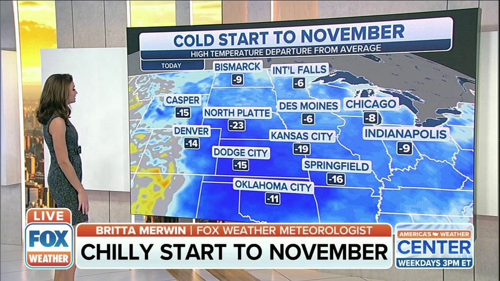
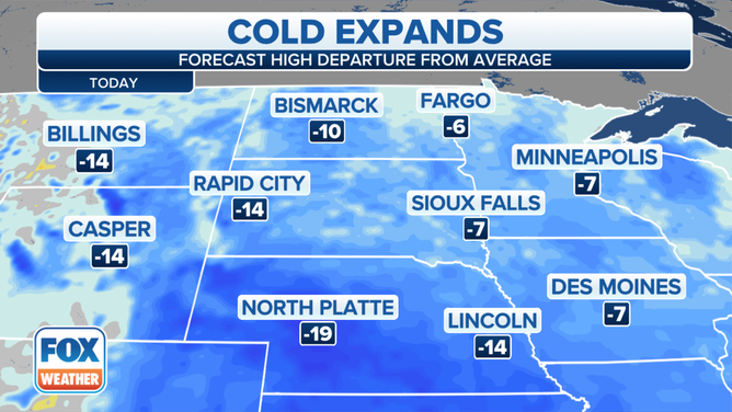
On Monday, high temperatures will be 10 to 20 degrees below average across the Northern and Central Plains and parts of the upper Midwest. This translates to highs in the 40s in most areas.
Minneapolis/St. Paul is projected to see highs in the lower 40s Monday through Wednesday. This will be the coldest stretch of weather there since April 19-21, when highs were stuck in the lower 40s on three straight days.
Forecast highs compared to average on Monday, Nov. 1, 2021.
(FOX Weather)
Temperatures will dip to 15 to 25 degrees below average Tuesday in the Central and Southern Plains, yielding highs in the 40s as far south as Oklahoma and the Texas Panhandle.
Farther east, highs will be in the 40s and 50s from the Midwest to New England and southward into the mid-Atlantic, Tennessee Valley and mid-South. These temperatures and generally 5 to 15 degrees colder than average for early November.
Forecast highs compared to average on Tuesday, Nov. 2, 2021.
(FOX Weather)
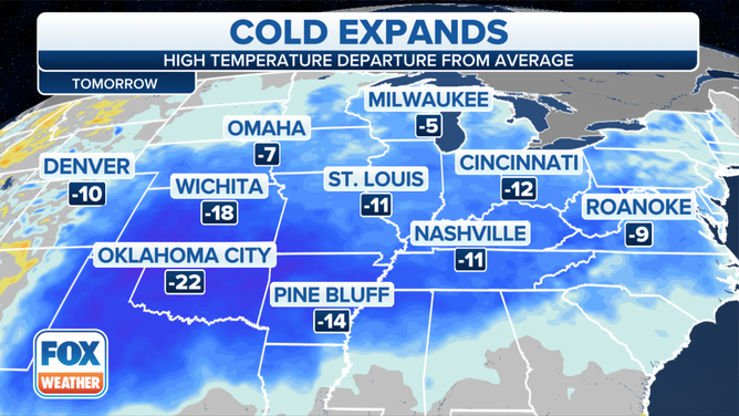
The chilly air will expand even farther south and east by Wednesday. High temperatures will be stuck in the 50s from North Texas to the Tennessee Valley, with highs in the 40s across Oklahoma, Arkansas, northern Mississippi, western Tennessee, Missouri and Kansas.
Temperatures will also be in the 40s Wednesday across the entire northern tier of the nation from the Northern Plains to the Midwest, Ohio Valley and interior Northeast, with the 50s expected along the Interstate 95 corridor.
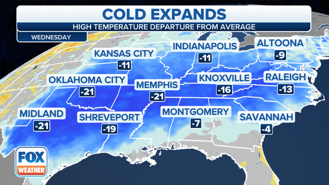
Forecast highs compared to average on Wednesday, Nov. 3, 2021.
(FOX Weather)
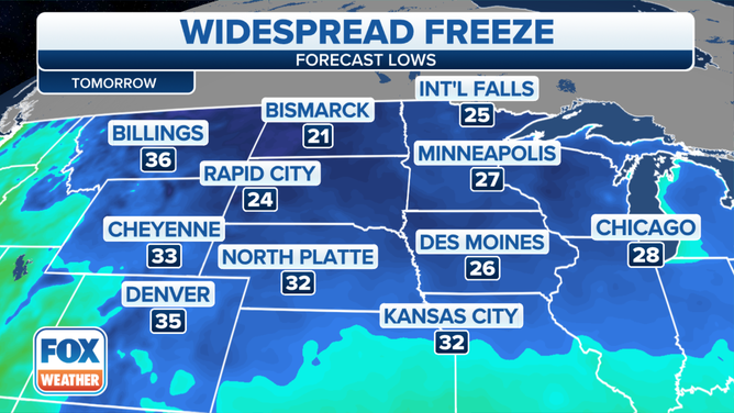
Low temperatures will dip below freezing in many areas the next several mornings.
Tuesday morning, the 32-degree or colder temperatures will likely stretch from Chicagoland southwestward through northern Missouri and Kansas. This will be the first freeze of the season in many of these cities, including Chicago and Kansas City.
HERE'S WHEN TO EXPECT YOUR FIRST FREEZE OF THE SEASON
Forecast low temperatures Tuesday morning, Nov. 2, 2021.
(FOX Weather)
Subfreezing lows are expected farther eastward by Wednesday morning, stretching all the way into northern portions of the Ohio Valley.
By Thursday morning, some parts of the Northeast might make a run at 32 degrees, with the best chance north and west of Interstate 95.
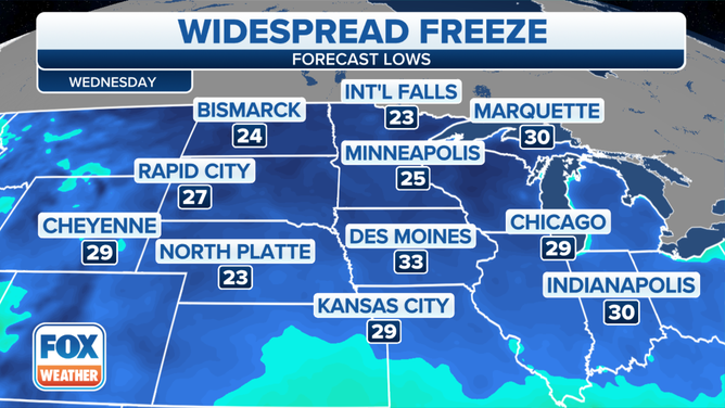
Forecast low temperatures Wednesday morning, Nov. 3, 2021.
(FOX Weather)
Snow expected in the Central Plains
This cold air invasion will also bring periods of snow to the Central Plains on Monday as a weak system moves across the region.
The National Weather Service has issued a Winter Weather Advisory for southwestern Nebraska and southeastern Wyoming through Monday afternoon. As much as 3 to 5 inches of snow is predicted to fall in some locations, which could lead to slippery and snow-covered roads if left untreated.
North Platte, Nebraska, had received 4.1 inches of snow as of 7 a.m. Central time Monday morning, according to the local NWS office.
WHEN CAN YOU EXPECT THE FIRST SNOW OF THE SEASON?
Other parts of Nebraska, northern Kansas and southwestern Iowa will also see their first snowflakes of the season from this system, but little or no accumulation is expected in these areas due to temperatures remaining safely above freezing.