Thirsty California reservoirs benefit from atmospheric river storms but drought is far from over
While all of this rain has helped the drought situation in California, there's still a long way to go. According to the California Department of Water Resources, many of the state’s reservoirs remain below capacity but are at or above their historical averages for this time of year.
California finally gets break after weeks of relentless rain
FOX Weather's Max Gorden is in Santa Monica, California and takes a look back at the weeks of rain and snow that hit the state.
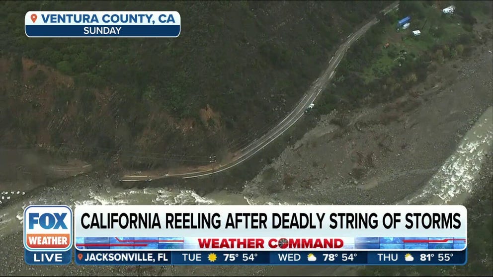
SACRAMENTO, Calif. - It's been an extremely turbulent few weeks in California as the Golden State has had to endure a bomb cyclone and a barrage of deadly atmospheric river storms of the Pineapple Express variety. All of that has created mudslides, led to beach erosion and left the region inundated.
The relentless moisture has led to a sharp rise in reservoir levels across California. In at least one case, it has been too much water for them to handle.

The current capacity of some of California's major reservoirs.
According to the California Department of Water Resources (CDWR), many of the state's reservoirs remain below capacity but are at or above their historical averages for this time of year.
For example, Lake Oroville was at 57% of its more than 3.5 million-acre-foot capacity as of Jan. 17. Data from the CDWR showed the current water level is 104% of its historical average.
Water levels in the reservoirs are measured in acre-feet. According to the Water Education Foundation, an acre-foot is about 326,000 gallons, or enough to fill an acre of land with one foot of water.
![The Lake Oroville reservoir level.]() Image 1 of 3
Image 1 of 3The Lake Oroville reservoir level. ( )
![The Shasta Lake reservoir level.]() Image 2 of 3
Image 2 of 3The Shasta Lake reservoir level. ( )
![The Trinity Lake reservoir level.]() Image 3 of 3
Image 3 of 3The Trinity Lake reservoir level. ( )


Shasta Lake was also well below its capacity of more than 4.5 million acre-feet as of Jan. 17. After the barrage of storms over the past few weeks, the lake is at 52% of capacity. According to LakesOnline.com, Shasta Lake was sitting at 921.1 feet on Dec. 26, 2022. The water level rose to 975.5 feet as of Jan. 16 – a rise of 54.4 feet.
Other major reservoirs have also seen sharp rises in their water levels since the storms began.
The Don Pedro Reservoir, which sits in the Sierra Nevada foothills to the east of Modesto, California, has a capacity of just over 1.5 million acre-feet. On Dec. 26, the level sat at about 736 feet. After the storms came through, that level rose more than 46 feet to 782.9 feet as of Jan. 17. According to the CDWR, the reservoir was at 74% capacity as of Jan. 17 and was at 107% of its historical average for this time of year.
Water released from Lake Mendocino reservoir
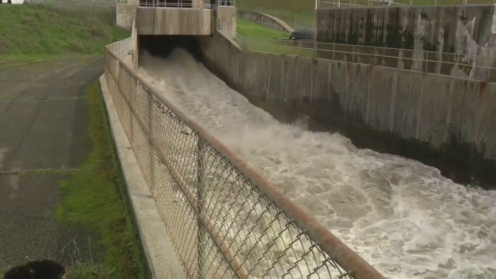
U.S. Army Corps of Engineers releases water from Lake Mendocino reservoir
The U.S. Army Corp of Engineers released water from the Lake Mendocino Reservoir because water levels were getting too high. KTVU reporter Tom Vacar has the story from California.
While the state's reservoirs have been thirsty for water, some have received too much.
According to a report from FOX 2 San Francisco, the U.S. Army Corps of Engineers began to release water Monday from the Lake Mendocino reservoir. Rising water has already overtaken parts of the boat ramp and is starting to invade the flood pool, which led to the decision to release water before it spills over.
"Keep it controlled, cut off the top and spread it out over a longer bit of time, and that makes all the communities that are close safe," U.S. Army Corps of Engineers Regional Director Lt. Col. Kevin Arnett told KTVU.
It's quite the change to go from water conservation to flood control.
"We're seeing a lot of areas kind of pivot from drought response from trying to recover storage into changing and doing some flood releases," California State Climatologist Mike Anderson told KTVU. "It does potentially set the stage for dealing with flood issues as we move through the snow melt season."
Lake Mendocino was at 752.85 feet as of Jan. 17, which is just under 12 feet below full.
WILL CALIFORNIA'S LONG-TERM DROUGHT IMPROVE AFTER ATMOSPHERIC RIVERS HAMMER THE WEST?
How much rain and snow have fallen in California over the past few weeks?
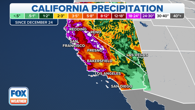
Some parts of California have picked up more than 40 inches of precipitation since Christmas Eve.
(FOX Weather)
Since the end of December, many areas of California have picked up feet of rain. In some instances, more than 40 inches of precipitation has fallen since the onslaught of atmospheric river storms began.
All of that water has left the land oversaturated, leading to rivers overflowing their banks. Several mudslides have also been reported because of the copious amounts of rain.
The drastic difference is depicted in this satellite imagery, which shows the change in landscape from last summer to this month,
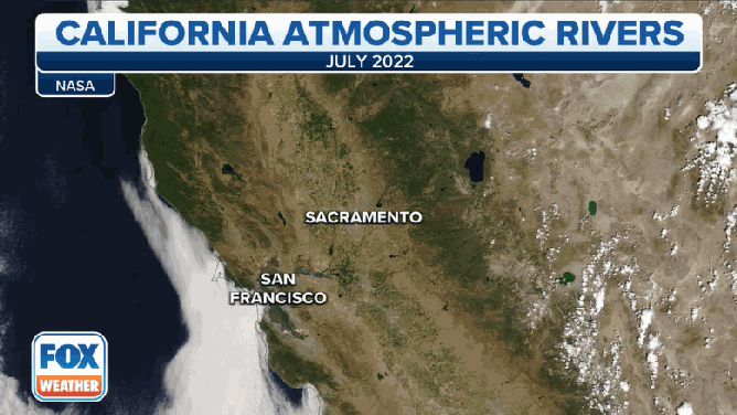
A look at the difference in landscape from July 2022 to January 2023.
(FOX Weather)
In the mountains, feet of snow have fallen during all of the storms.
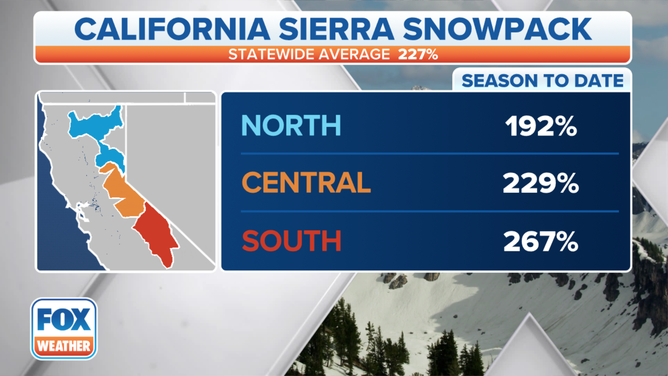
The current California Sierra snowpack.
(FOX Weather)
The Central Sierra Snow Lab reported over the weekend that it had more than 200% of average precipitation. The northern Sierra Nevada mountain range is currently sitting at 192% of average precipitation, and the southern Sierra Nevada range is at 267% of average.
The Sierra snowpack is also where much of the state's water is stored, according to the Sierra Nevada Conservancy. That snowpack supplies drinking water to more than 75% of Californians. As the snow melts in the spring, the runoff replenishes reservoirs before the dry season in the summer.
WHAT CALIFORNIA'S EXCESSIVE SNOW MEANS FOR SPRING AND THE MEGADROUGHT
How has the onslaught of storms affected the drought?
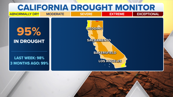
The latest U.S. Drought Monitor shows 95% of California remains in drought, but that's an improvement over last week's 98% drought coverage in the state.
(FOX Weather)
While all of this rain has helped the drought situation in California, there's still a long way to go.
Nearly the entire state is now out of the extreme and exceptional drought categories, with less than 1% of California remaining in extreme drought.
About 95% of the state is still experiencing some level of drought, according to the latest information from the U.S. Drought Monitor. That is still an improvement over the previous week when drought covered 98% of the state.
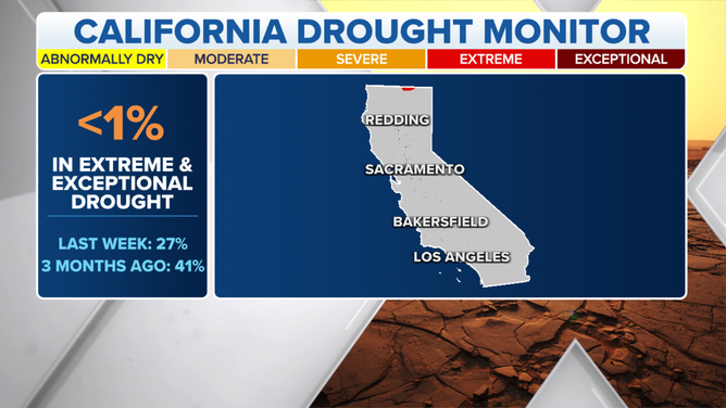
As of last week, only 1% of California was experiencing extreme drought.
(FOX Weather)
Rich Tinker, the U.S. Drought Monitor author with the National Oceanic and Atmospheric Administration, said he is cautiously optimistic about the drought situation.
"The reservoirs, of course, is the big issue for most of what goes on in most of California, and water management is pretty heavy," he said. "So, it takes a long time for reservoirs to deplete, and it also takes a while for them to refill. So, we're doing considerably better. We're still not even up to what's normal for this time of year, however."
So, while Californians may be breathing a sigh of relief, some scientists said it may be too soon to celebrate.