Bryan Norcross: Watching for development in the Caribbean after all
The tropical disturbance just east of the central Bahamas is officially tagged Invest 96L by the National Hurricane Center.

FOX Weather is your Hurricane HQ, streaming free 24/7.
(FOX Weather)
Updated at 9:30 a.m. EDT on Monday
Two disturbances have spawned from a long ribbon of low pressure that extended out of now-deceased Tropical Storm Tammy well to the north – one north of the Caribbean east of the Bahamas and one in the Caribbean Sea. Both have some chance of developing into at least a tropical depression.
The tropical disturbance just east of the central Bahamas is officially tagged Invest 96L by the National Hurricane Center. Winds over 40 mph have been measured on the side of the system away from land, so it would be named Tropical Storm Vince if it could organize a circulation. That looks unlikely, however.
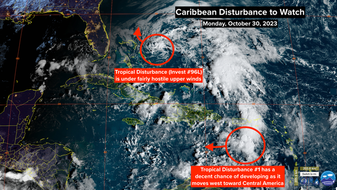
A satellite image of Invest 96L and a tropical disturbance on Monday, Oct. 30, 2023.
(NOAA)
Strong upper-level winds blowing over the system are keeping it out of kilter. By tomorrow, they will only increase, and dry air will likely disrupt the system completely before it gets absorbed by a cold front on Wednesday.
The system might wander close to the Abacos in the northwest Bahamas before dissipating. Boaters there should keep up with the forecasts just in case.
In the eastern Caribbean, Tropical Disturbance No. 1 is a large area of disorganized thunderstorms. As it tracks to the west toward Central America this week, the atmospheric pattern looks conducive for the system to organize into a tropical depression or tropical storm.
A bubble of high pressure is forecast to slide north of the system this week, so that should trap it in the Caribbean until it reaches land. The question is, how conducive will the upper-wind pattern be? There is disagreement among the computer forecasts on how fast the system will move and, therefore, how well it aligns with the most supportive upper winds.
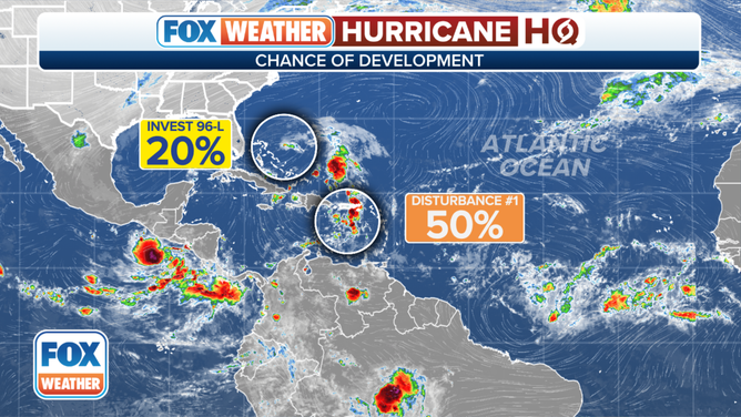
An overview of the tropical Atlantic Ocean on Monday, October 30, 2023.
(FOX Weather)
As always with systems that haven’t yet developed, the forecasts are subject to significant changes. So for now, we’ll just keep an eye on it, and everybody from Nicaragua to the Yucatán Peninsula of Mexico should stay informed this week. As of now, the system would arrive at the Central American coast late in the week or over the weekend.
Once it is near or over Central America, we’ll have to keep an eye on it to see if the disturbance or its moisture tries to move north ahead of an approaching fall front.
We are in the time of year when cold fronts keep tropical systems confined to the Caribbean – for the most part. But it’s not 100% out of the question for a brief corridor to open to the north.
In an El Niño year, upper-level winds are normally more hostile than normal over the Caribbean. At the moment, the band of storm-killing winds is across the Gulf and Florida, which might allow Tropical Disturbance No. 1 to develop.