Bryan Norcross: Tropics are heating up with 4 systems to watch
Indications are that hurricane season in the Atlantic is about to pick up. Now is the time to be sure you’re prepared.

FOX Weather is your Hurricane HQ, streaming free 24/7.
(FOX Weather / FOX Weather)
Updated Wednesday at 8:30 a.m.
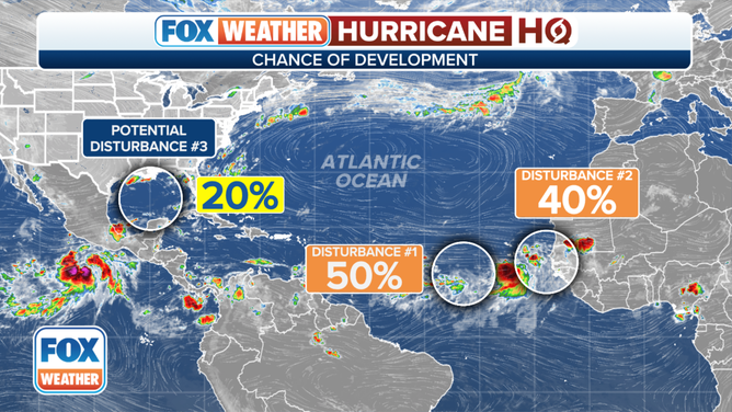
The National Hurricane Center is highlighting two disturbances on the other side of the Atlantic, one potential disturbance in the Gulf, and a likely tropical storm or hurricane in the Pacific that has a good chance of affecting Southern California and parts of the western United States.
An overview of the tropical Atlantic Ocean on Wednesday, August 16, 2023.
(FOX Weather)
In the Atlantic, Tropical Disturbance #1 is interacting with a broad area of disturbed weather, which is a regular feature in that part of the ocean during hurricane season. The National Hurricane Center is now giving this system a medium chance of breaking free of the broad disturbance and organizing into a tropical depression or tropical storm over the next several days.
The system is forecast to move in the general direction of the northeastern Caribbean islands, but the weather pattern is likely to change before it gets that far west. Complicating forecasts for this system is the possibility that it will interact with or be affected by Tropical Disturbance #2, assuming it develops.
Tropical Disturbance #2 has just moved off the African coast as a healthy cluster of thunderstorms. The National Hurricane is now also giving it a good chance of developing. Both systems will have Saharan dust and dry air to contend with. The dusty air and the proximity of the disturbances to one another present a range of possibilities.
In any case, neither system appears to be a threat to the Caribbean islands at this time. Computer forecasts show both systems turning north into the dry air. Although, Disturbance #1 might moisten the environment for Disturbance #2. It’s important to note that all forecasts for undeveloped or just-developing systems are subject to change.

NOAA satellite view monitoring two areas in the Atlantic for possible development.
(NOAA)
The dust belt that’s been concentrated in the eastern Atlantic lately is forecast to stretch out across the ocean, reaching Florida and the Gulf of Mexico over the weekend. The spreading out of the dust will tend to thin it out, and may well limit its restraining effect on tropical systems going forward. On average, the dust has less and less impact on disturbances coming off Africa about this time of year anyway. So we should expect more robust systems in the weeks ahead.
In the Gulf of Mexico, the National Hurricane Center is painting an area where there’s a slight chance a tropical depression could form in several days. There is already a broad zone of low pressure across the Gulf – the area between the massive high-pressure heat dome to the north and the Bermuda High over the Atlantic. A weak tropical disturbance is forecast to move into the Gulf early next week and migrate toward Texas or the northern Gulf coast. There is a slight chance it could develop into a depression before moving inland, but the main effect will likely be the rain.
A moisture surge would be a godsend for Texas and the Gulf Coast. It would lower the insane temperatures and bring some desperately needed rain. As of now, there’s no apparent threat that this could be a strong storm.
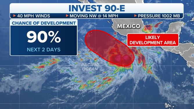
Invest 90E in the Eastern Pacific Ocean is given a high chance of development.
South California is watching developments off the coast of Mexico very carefully. A strong tropical disturbance looks likely to become Tropical Storm Hilary in short order. The track for the next few days is likely to be parallel to the Mexican coast in the direction of California.
The ocean water is quite cool – cooler than average – from well south of the U.S./Mexico border north to SoCal, which should diminish the intensity of the wind in the system if indeed it takes the unusual track near or over the California coast. Although it’s not 100% clear that the system won’t make a beeline for the San Diego area and maintain some very gusty winds.
In any case, the bigger threat will be from the tropical moisture interacting with the numerous mountain ranges across the Southland of California and spreading over the deserts.
It appears that a corridor will open up between a sharp dip in the jet stream along the West Coast and the super-strong heat dome over the central U.S. Tropical moisture from likely-Hilary has a good chance of spreading north in that river of air into the highly populated areas west of the Southern California mountains and the desert areas to the east.
The exact trajectory and intensity of the flow of moisture is unknowable. It depends on myriad factors, including the exact dimensions of the heat dome, the strength of likely-Hilary, and the exact orientation of the dip in the jet stream.
The estimate based on what we know is that the moisture will arrive in SoCal late Saturday or Sunday and last until at least Tuesday. The atmosphere will feel very un-Californian with high humidity and tropical downpours.
Flooding is a significant threat, although the extent and location of the biggest impacts are not knowable yet. Everybody in Southern California should stay especially well informed about the weather beginning about Sunday.
Indications are that hurricane season in the Atlantic is about to pick up. Now is the time to be sure you’re prepared.