Bryan Norcross: Giant system including ex-Philippe heading for New England, Atlantic Canada
Philippe’s main contribution to the massive system moving north is tropical moisture, which it pulled up from the Caribbean.

FOX Weather is your Hurricane HQ, streaming free 24/7.
(FOX Weather)
Updated Saturday 9:15 a.m. ET
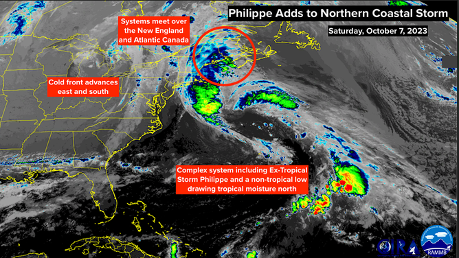
Former Tropical Storm Philippe quasi-merged into a huge non-tropical low-pressure system well offshore of the Carolina coast yesterday. It is only quasi-merged because ex-Philippe is still identifiable in the massive comma-shaped system moving north toward northern New England, New Brunswick, and Nova Scotia in Canada.
Philippe’s main contribution to the massive system moving north is tropical moisture, which it pulled up from the Caribbean.
The moisture-laden Atlantic system will meet a brisk fall cold front near the Maine/Canada border tonight, producing corridors of heavy rain from New Jersey to northern New England and into Canada. Stay alert to local flood alerts.
Former Tropical Storm Philippe quasi-merged into a huge non-tropical low-pressure system well offshore of the Carolina coast yesterday.
The strongest winds will likely impact Atlantic Canada, which will be on the east side of the combo system.
The various weather systems converging to create the bad weather today will be absorbed into a large Canadian storm by late tomorrow, which will eventually head into the North Atlantic.
In the eastern tropical Atlantic, a disturbance that moved off Africa yesterday is showing signs of organization. The National Hurricane Center gives it a high chance of developing into at least a tropical depression next week. The weather pattern is forecast to be marginally conducive for the system to organize for a few days. There’s a slight chance it could become Tropical Storm Sean.
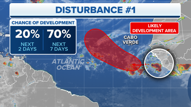
Tracking a disturbance in the eastern Atlantic.
(FOX Weather)
The typical high-pressure system across the Atlantic is quite weak at the current time, so there is nothing to hold the system south. The depression or storm will likely turn north and dissipate under hostile upper winds after a few days.
Disturbances continue to move off Africa in October, but it becomes harder for them to intensify and move very far west. The increasingly robust and deep autumn dips in the jet stream, which drive cool air into the U.S., propagate across the Atlantic. Tropical systems that stick their heads up (get very strong) get scooped to the north.
Our focus for the rest of the season will be in the western Caribbean, the southern Gulf of Mexico, and over the Gulf Stream around Florida and the East Coast. Sometimes weak disturbances make it all the way across the Atlantic. Other times, fronts or non-tropical low-pressure systems sit over the still very warm waters and develop. There’s no sign of that yet, but there’s lots of October to go.