Bryan Norcross: Major rain threat from the Caribbean and the Florida low-pressure systems
The National Hurricane Center is painting an area offshore of Florida to the Carolinas, indicating that the system could briefly take on some tropical characteristics while it tracks over the warm Gulf Stream. The odds of the system becoming somewhat tropical are very low.

FOX Weather is your Hurricane HQ, streaming free 24/7.
(FOX Weather)
Updated Wednesday at 9:15 a.m. EST
An area of low pressure is forecast to form off southeast Florida tomorrow and move north along the coast. This is the same type of meteorological development we see in the winter when a nor’easter forms off the Carolinas and becomes a snowstorm in the big cities farther north.
The National Hurricane Center is painting an area offshore of Florida to the Carolinas, indicating that the system could briefly take on some tropical characteristics while it tracks over the warm Gulf Stream. The odds of the system becoming somewhat tropical are very low. In any case, it wouldn’t make any difference to the impacts from the low-pressure system forecast to track north offshore of the East Coast through Saturday.
The current forecasts only brush the East Coast as the windy and rainy storm tracks offshore, but coastal residents should stay in touch with the latest local forecasts since the system hasn’t yet developed.
The tropical weather outlook for the Atlantic Ocean.
(FOX Weather)
The new low-pressure center that will develop off Florida tomorrow will steal energy from the current Gulf system and its associated front and upper-air dip in the jet stream. This combo has pounded South Florida with torrential rain and flooding. When the Atlantic system finally develops, South Florida will dry out.
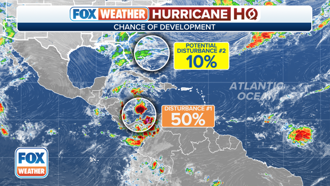
In the Caribbean, the long-anticipated broad disturbance now appears less likely to develop into a tropical system. The wind regime affecting the south-central Caribbean is keeping the system disorganized.
The National Hurricane Center is still giving the disturbance a medium chance of becoming at least a tropical depression over the next several days, but the main threat from the system is the large amount of tropical moisture that will flow north over the mountainous Caribbean islands.
The Caribbean moisture will combine with a cold front attached to the developing Florida low-pressure system to create the potential for periods of very heavy rain starting in earnest tomorrow and lasting at least through Saturday, especially on the windward side of the mountains.
Residents in Jamaica, eastern Cuba, Haiti, the Dominican Republic, the southeastern Bahamas, the Turks and Caicos and Puerto Rico should stay informed on the latest local forecasts.