Bryan Norcross: Potential Caribbean development still on the table
The National Hurricane Center is now giving the disturbance a medium chance of developing into at least a tropical depression this week.

FOX Weather is your Hurricane HQ, streaming free 24/7.
(FOX Weather / FOX Weather)
Updated at 9:30 a.m. Sunday
A large cluster of thunderstorms persists just north of the Panamanian coast in the extreme southern Caribbean. The current weather pattern is hostile to development, but by the middle of the week, the environment is forecast to change.
A strong non-tropical low-pressure system moving along the northern Gulf coast will produce wet and windy weather from Texas to Florida over the next few days. It will also change the upper-level winds into a more conducive configuration for a system to develop in the Caribbean.
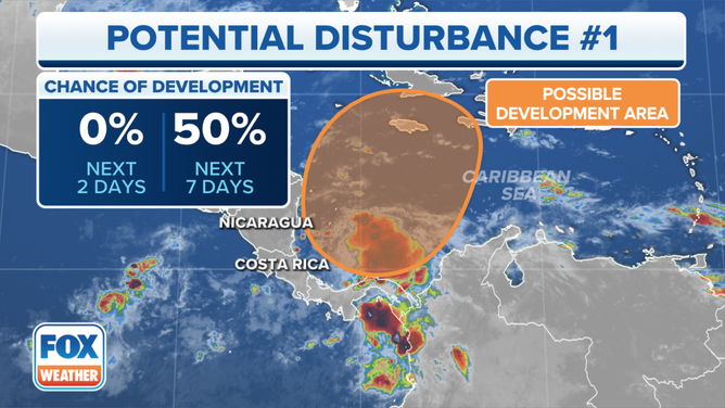
Forecasters are monitoring an area in the Caribbean that has a medium chance of developing into a tropical depression over the next week.
(FOX Weather)
The National Hurricane Center is now giving the disturbance a medium chance of developing into at least a tropical depression this week.
Most computer forecasts now indicate that a tropical system will slowly organize mid to late week. But how quickly it pulls itself together and where it will track are open questions. The consensus is that development will be slow, and if it is scooped out of the Caribbean by a jet stream dip to the north, it will move in the direction of Jamaica, eastern Cuba, Haiti, the Dominican Republic, and the southeastern Bahamas.
Strong upper-level winds and advancing cold fronts should keep the system, even if it tracks to the north, away from the continental U.S.
The future track appears to be dependent on how strong it can get, and exactly how deep the jet stream dips are that might pull it north. As always, until an organized system develops, the forecasting systems don’t have anything to latch onto. Uncertainty at the beginning of the forecast cycle only increases with time.
For now, people in the northern Caribbean islands and the southeastern Bahamas should plan to stay in touch with the latest forecasts mid to late week.