Bryan Norcross: Philippe moving north toward Bermuda, could affect New England
The general idea for Philippe’s future track is that the storm will pass near Bermuda early tomorrow and reach the coast of northern Maine or Nova Scotia, Canada Saturday night or Sunday.

FOX Weather is your Hurricane HQ, streaming free 24/7.
(FOX Weather)
Updated Thursday 9:30 a.m. ET
Tropical Storm Philippe has finally moved well north of the Caribbean, although it is still dragging some moisture over the islands. Soil is saturated in the mountainous areas, so a moderate flood threat remains from any tropical downpours that occur over the next couple of days.
The general idea for Philippe’s future track is that the storm will pass near Bermuda early tomorrow and reach the coast of northern Maine or Nova Scotia, Canada Saturday night or Sunday. But since we are talking about one of the orneriest storms in recent memory, Philippe will not get where it’s going without zigging and zagging in hard-to-predict ways.
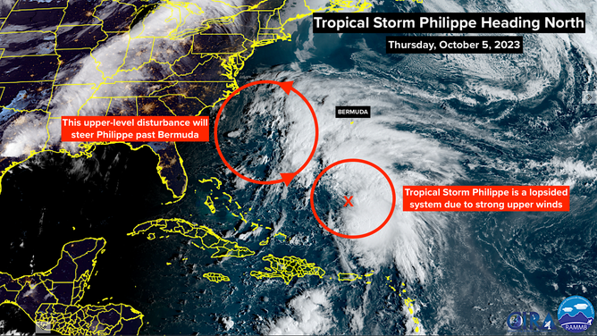
A satellite image of Tropical Storm Philippe on Thursday, October 5, 2023.
(NOAA)
Between Philippe and the Southeast U.S., there’s a large non-tropical low. This is the system that pushed a front through Florida earlier this week. The circulation around that low is pulling Philippe to the north and also helping to drag moisture out of the Caribbean over the islands. The exact orientation of the river of air on the east side of the low-pressure system will dictate how close Philippe comes to Bermuda. In any case, a Tropical Storm Warning is in effect on the island because some impact is expected.
Beginning tomorrow, Philippe and that non-tropical low will move north in tandem. (Of course, because Philippe can’t seem to do anything alone. Recall its earlier sashay with Tropical Storm Rina.) A sharp dip in the jet stream is forecast to set up over the Great Lakes, which will scoop those systems north in a hurry.
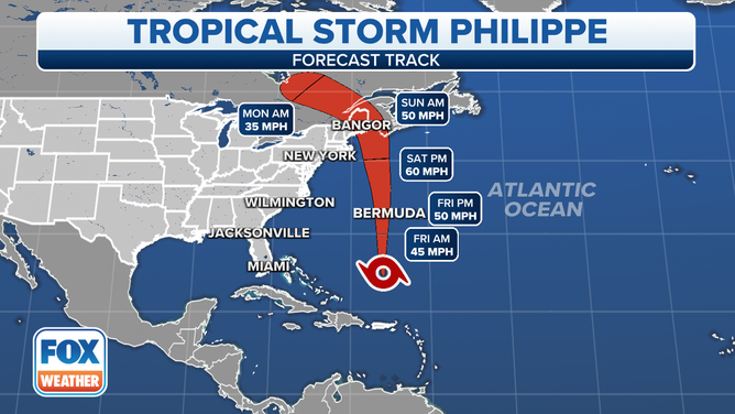
The forecast track for Tropical Storm Philippe.
(FOX Weather)
The meteorology is a mess with myriad competing factors, but it appears that the Philippe/low-pressure combo will get some energy from the jet stream dip even after they run out of warm ocean water. Whether there is much tropical aspect to the system that comes ashore somewhere near the border between Maine and Canada is an open question, but it won’t make much difference to the impact.
Regardless of the meteorological niceties, the system will bring a large area of high winds. In New England and the Northeast, the winds will come off the land, so storm surge won’t be an issue. But in Atlantic Canada, the winds will be the strongest in the storm and will be blowing onshore.
The storm will move north into Canada on Sunday and slowly weaken.
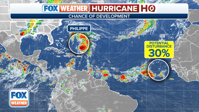
An overview of the tropical Atlantic Ocean on Thursday, October 5, 2023.
(FOX Weather)
Elsewhere in the Atlantic, a disturbance is forecast to move off Africa this weekend. The National Hurricane Center is giving it a low chance of developing into at least a tropical depression over the tropical Atlantic. There’s no indication it would be a threat to land at the current time.
We’re getting late in the season for East Atlantic systems. The atmospheric pattern normally becomes more hostile over that part of the ocean in October. This year, the water temperatures are exceptionally warm, of course. So we’ll watch there a bit longer.
Otherwise, a long front that will be loosely associated with Philippe and the non-tropical low might settle across the Gulf of Mexico next week. We’ll keep an eye on that.