Bryan Norcross: Odds of significant impacts from Hurricane Lee in New England are increasing
The cone can be misleading in terms of the storm’s track as well. The evidence from the computer forecasts is that Lee will make a slight jog toward land when it’s in the vicinity of New England, which the cone doesn’t capture. So don’t be surprised by a slightly S-shaped track.

FOX Weather is your Hurricane HQ, streaming free 24/7.
(FOX Weather / FOX Weather)
Updated at 9:15 a.m. ET Wednesday
There are two camps in the computer forecasts. One group takes the center of Hurricane Lee far enough away from New England that the heavy rain and winds gusting to hurricane force would brush Cape Cod, Massachusetts, which sticks out into the ocean, but less impactful conditions would occur over the mainland.
The other group brings brutal heavy rain and damaging winds over the I-95 corridor from southeastern Massachusetts to the northeastern part of Maine, which is called Downeast Maine.
In the scenario where Lee’s center of circulation comes reasonably close to the New England coast, gusty north and northwest winds strong enough to do some damage and knock out power could also affect part of Connecticut, Rhode Island, and the eastern half of Long Island, New York.
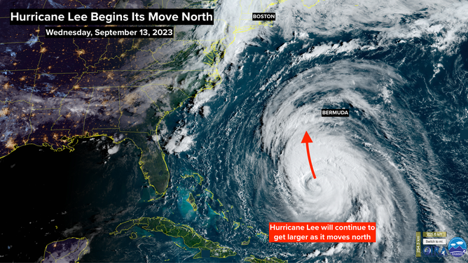
A satellite image of Hurricane Lee.
(NOAA)
This storm is an extreme example of a time when you do not want to look at the forecast cone to determine what areas are threatened. Winds of 40 mph or higher are forecast to extend west some 250 miles from the Lee’s center. Besides the potential effect on land, the large-diameter storm will put a tremendous amount of energy in the Western Atlantic Ocean, and the wind will direct that energy toward the coast.
The cone can be misleading in terms of the storm’s track as well. The evidence from the computer forecasts is that Lee will make a slight jog toward land when it’s in the vicinity of New England, which the cone doesn’t capture. So don’t be surprised by a slightly S-shaped track.
On the current schedule, the intense surge of ocean energy will reach the mid-Atlantic waters – nominally from North Carolina to Long Island, New York – on Friday. Then on Saturday, an even stronger surge of energy reaches the Gulf of Maine – from Cape Cod to Downeast Maine. Atlantic Canada impacts come Saturday as well.
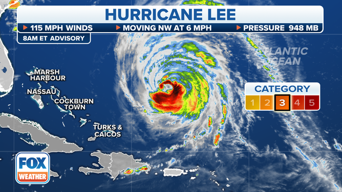
The 8 a.m. Hurricane Lee advisory.
(FOX Weather)
Extra-large, hurricane-powered waves will pound the coast with extremely strong undertows from swells emanating from the storm. Beach erosion and damage to exposed areas are possible. In New England, if the storm tracks close enough, storm surge will be a major threat in Cape Cod Bay and along the coast to the north. Harbors and inlets are especially vulnerable.
Marine interests will be at particular risk from Lee. Preparation in threatened areas should begin today.
On the current schedule, the winds will pick up by late Friday in southeastern New England. Strong winds and rain arrive overnight. The peak of the storm is Saturday. Sunday the winds die down, and the system is past by Sunday afternoon. Impacts occur a little later in Maine and Atlantic Canada.
The conditions and threats will vary across the region. The ground is saturated, and streams are full in many locations, so Lee’s rain could cause significant flooding. Seek out local emergency information and watch out for National Weather Service or Environment Canada warnings issued for your area.
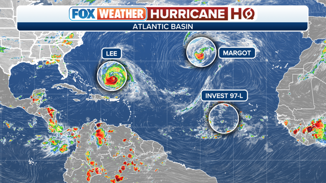
An overview of the tropical Atlantic Ocean on Wednesday, September 13, 2023.
(FOX Weather)
Out in the Atlantic, Hurricane Margot continues to drift north. It’s not a threat to land.
The next system, the Tropical Disturbance officially tagged Invest #97L, appears likely to become Tropical Storm Nigel. Long-range computer forecasts show it heading on a path similar to Lee and then encountering a big dip in the jet stream, which would deflect it north before reaching the U.S. The timing is critical, however. We will be watching it for the next week or more.