Bryan Norcross: New named storm possible in the Atlantic while Calvin heads toward Hawaii
In a year when so much attention has (rightfully) been paid to the extreme water temperatures around the world, it’s interesting that potential Don is in the part of the Atlantic that is closest to normal.

Generic Hurricane HQ
(FOX Weather)
Updated Thursday 9:30 a.m. EDT
The system we’ve been tracking in the central Atlantic has a clear circulation, but the thunderstorms are shunted off to the east, not wrapped around the center. Computer forecasts indicate it has a decent chance of organizing over the next couple of days.
The National Hurricane Center is calling it Invest 94L, meaning it’s being investigated. They give it a medium chance of developing into a depression or storm.
The system already has winds approaching 40 mph, so it will likely get the name Don if it can pull itself together. The only interesting thing about this potential storm, since it’s well away from land, is its unusualness.
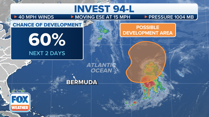
The outlook for Invest 94L in the central Atlantic Ocean.
(FOX Weather)
We normally don’t see tropical or quasi-tropical systems develop in this part of the ocean in July, and on average, the fifth named storm of the season doesn’t come along until Aug. 22. Recall that the posthumously named January subtropical storm is on the 2023 list, plus we had the A-to-C systems in June.
In a year when so much attention has (rightfully) been paid to the extreme water temperatures around the world, it’s interesting that potential Don is in the part of the Atlantic that is closest to normal.
On this map from NOAA, the band of oranges and reds from Africa to the Gulf of Mexico is obvious. The highest water temperatures on record have been measured in parts of that belt, largely related to lighter-than-normal winds blowing across the ocean. Although the chicken-or-the-egg relationship between water temperatures and the strength of the wind is complex.
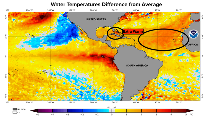
Water temperatures compared to average.
(NOAA)
Notice the bright reds around Florida and the Bahamas, which is the main cause of the high humidity levels across South Florida this summer.
With many pockets of wildly out-of-whack weather around the globe, a typical and good thing is that Saharan dust is blanketing the tropical belt. The dust keeps some sunlight and heat from reaching the already-hot ocean. Plus it helps create a hostile atmosphere for hurricanes. So no threatening systems are expected in the Atlantic, the Caribbean, or the Gulf of Mexico for the next week at least.
In the Pacific, Calvin is forecast to become a hurricane as it heads in the general direction of Hawaii. The consensus of the long-range computer predictions is that the system will affect the island around the middle of next week. Calvin will likely have weakened significantly from its peak strength by that time, but gusty winds and heavy rain are still possible. Stay aware.