Bryan Norcross: New area in the Atlantic to watch
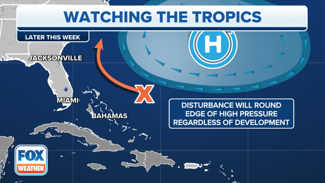
The main computer forecast models don’t show the system developing, but they do predict an area of disturbed weather affecting the coast. At this point, some kind of organized development appears unlikely but not impossible.

FOX Weather is your Hurricane HQ, streaming free 24/7.
(FOX Weather)
UPDATED Tuesday at 8:30 a.m.
The National Hurricane Center is noting an elongated area of disturbed weather south of Bermuda and east of the Bahamas. The line of thunderstorms is being triggered by a low-pressure kink in the flow around the typical summertime Bermuda high.
Sometimes a low-pressure area with concentrated thunderstorms moving over the warm ocean can develop circulation and turn into a tropical system. Although it’s typically a slow process.
The NHC odds for this disturbance to develop are low. On the current schedule, the system would be somewhere near the southeast coast by Thursday or Friday, whether it organizes or not. Since there is no center to track at this point, any effects from the system beyond an increase in thunderstorm activity can’t be pinned down.
A tropical disturbance spotted in the Atlantic Ocean could develop while heading toward the southeastern U.S., hurricane forecasters warn.
(FOX Weather)
The main computer forecast models don’t show the system developing, but they do predict an area of disturbed weather affecting the coast. At this point, some kind of organized development appears unlikely but not impossible. Thus, the recognition by the National Hurricane Center.
To the south, the tropical disturbance Invest 95L we've been tracking is passing over the eastern Caribbean islands today. Downpours and some gusty winds are likely.
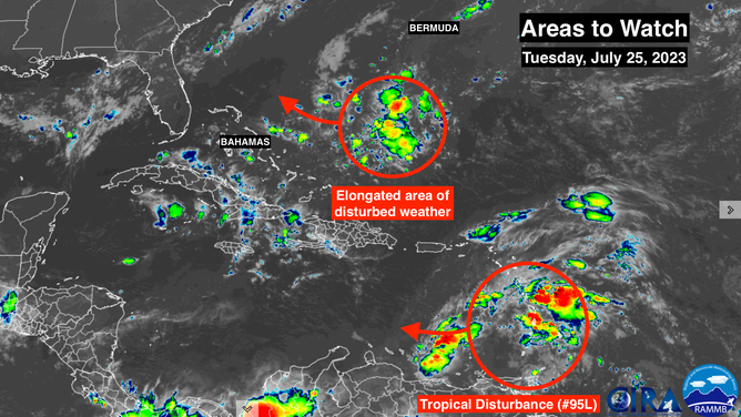
Satellite imagery of a new disturbance and Invest 95L in the Atlantic.
(NOAA)
The odds are now very low that this disturbance will organize into a tropical depression. The upper-level winds will become increasingly unfavorable. Most likely, the system will move through the Caribbean and into Central America as simply a moisture surge.
Elsewhere, Saharan Dust continues to dominate the tropical Atlantic, which will keep the odds of development down. Beyond the two low-odds systems, nothing is expected to develop through the weekend.