Bryan Norcross: Lee exits the stage as Tropical Storm Nigel forms in the Atlantic
An even stronger dip in the jet stream than the one that kept Lee away from the U.S. East Coast is coming along. It should turn Nigel to the north well offshore.

FOX Weather is your Hurricane HQ, streaming free 24/7.
(FOX Weather / FOX Weather)
UPDATED Sunday at 8 a.m.
Ex-Hurricane Lee morphed into a non-tropical nor’easter-type storm yesterday. It’s now in its final weakening stage as it speeds across eastern Atlantic Canada into the North Atlantic. Waves and currents will continue to affect coastal areas from the U.S. East Coast to the Caribbean for a day or two.
In the middle of the Atlantic, Tropical Storm Nigel has formed. The ocean is very warm, and the atmospheric pattern is forecast to be conducive for strengthening, so the National Hurricane Center is predicting that Nigel will become at least a Category 3 hurricane in the next few days.
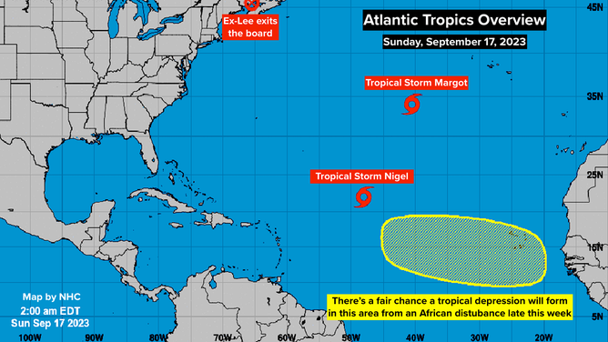
The tropical Atlantic overview.
(NOAA)
An even stronger dip in the jet stream than the one that kept Lee away from the U.S. East Coast is coming along. It should turn Nigel to the north well offshore. There was some thought that Bermuda might be threatened, but it appears Nigel will pass well to the east of the island. Although, until the storm gets fully organized, forecasts are subject to change, of course.
Tropical Storm Margot is on its last legs in the middle of the Atlantic. This should be its final day.
About midweek, a vigorous disturbance is forecast to move off the coast of Africa. The National Hurricane Center is giving it a fair chance of developing into a tropical depression over the tropical Atlantic over later this week.
These dips in the jet stream that have been protecting the eastern part of the U.S. are related to the cold fronts that have begun to move south. As long as they keep up, we’re good along the East Coast. Although fronts that get into the Gulf or Caribbean can be triggers for storms in October. But there’s no sign of anything developing close to home in the next week or two.