Bryan Norcross: Hurricane Tammy pulling away from the Caribbean islands
A weaker version of Tammy might eventually loop around the quasi-stationary upper low back toward the U.S. coast. The system does not appear to be a threat to land at this time, although Bermuda will have to keep an eye on it.

FOX Weather is your Hurricane HQ, streaming free 24/7.
(FOX Weather)
Updated Sunday at 9:30 a.m. EDT
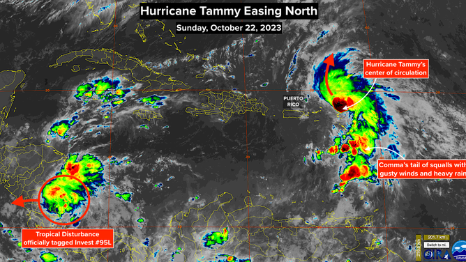
The center of Hurricane Tammy has moved north of the Caribbean and is heading into the open ocean. The strongest winds in the tiny core of the storm brushed Guadeloupe in the eastern Caribbean and went over Barbuda, the most northeastern island in the Leeward chain.
Tammy has always had a comma shape with a band of squalls with heavy rain and gusty winds arcing south from the center. And that structure continues. It will take a few more days for Tammy’s moisture tail to clear all of the islands.
There is high confidence that Tammy will continue north for the next couple of days, but by Tuesday, the future track becomes uncertain. The surge of warm air forecast over the East Coast of the U.S. is caused by a big bubble of high pressure pushing the jet stream north. Like shaking a garden hose to create big undulations, the jet stream will respond by creating a sharp dip offshore, which will evolve into a lumbering upper-level low-pressure system.
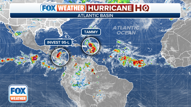
Atlantic tropical overview.
(FOX Weather)
Exactly how the large upper low will direct, strengthen, weaken, and/or absorb Tammy is uncertain. The various computer forecasts present a variety of scenarios. It appears most likely that the storm will strengthen a bit north of the islands and then come under the upper low’s influence.
A weaker version of Tammy might eventually loop around the quasi-stationary upper low back toward the U.S. coast. The system does not appear to be a threat to land at this time, although Bermuda will have to keep an eye on it.
NOAA satellite imagery shows Hurricane Tammy in the Atlantic.
(NOAA)
In October, we get a combination of tropical systems and northern winterlike systems vying for the same space on the planet, thus the odd and unusual looping or zig-zaggy tracks. Since the uncertainty is high, we’ll have to keep an eye on things to be sure the drama plays out over the open ocean and surprises are kept to a minimum.
In the extreme southern Caribbean Sea, a tropical disturbance, now officially tagged Invest 95L, is flaring up just off the coast of Nicaragua. The National Hurricane Center is giving it a medium chance of developing into at least a tropical depression over the next couple of days before it moves over the Nicaraguan coast about Tuesday.
The upper-level winds over that part of the Caribbean are conducive for the system to develop. In response, the computer forecasts give it a fair chance of briefly becoming Tropical Storm Vince.
Otherwise, dry air will cover Florida, the Gulf and the surrounding areas this week, which will deprive anything tropical of the moisture it needs to operate.