Powerful Hurricane Ian a worst-case scenario for Southwest Florida
The hurricane is as bad as it can be. The winds are not yet Category 5, but the diameter of the storm has expanded, which is worse. The bigger donut of winds moves more water making storm surge higher. The slow forward progress of this storm will add to the height of the surge.
The podcast Tracking the Tropics with Bryan Norcross is now available to stream.
(FOX Weather)
Visit the FOX Weather Wire for live updates on Hurricane Ian as it rips through Florida. Click here for the latest forecast, evacuation orders and more.
Updated at 8:30 a.m. Eastern
It’s fair to say that prominent parts of Southwest Florida from south of Fort Myers to north of Charlotte Harbor – about 50 miles of coastline – will be changed forever.
Gulf water will top most of the barrier islands destroying many or most structures. People left in the storm-surge zone may not survive. The surge will arrive this afternoon.
The hurricane is as bad as it can be. The winds are not yet Category 5, but the diameter of the storm has expanded, which is worse. The bigger donut of winds moves more water making storm surge higher. The slow forward progress of this storm will add to the height of the surge.

(FOX Weather)
The forecast is for 12 to 16 feet of Gulf water above the normal HIGH tide level. This will push water over the islands and the coastline, into the harbors, and up the rivers and over their banks at deadly heights. The surge can go up to 10 miles inland, depending on the river.
A large part of Cape Coral and Fort Myers along the Caloosahatchee River are likely to go underwater.
High tide comes this afternoon about the time the surge will peak for some areas in the Greater Fort Myers area. This will add a couple feet to the surge. The tide is already extra high because we’re in King Tide season.
The Naples areas will see slightly less, 7 to 11 feet of water rise is still forecast near the coast this afternoon.
Destructive winds will rip through Southwest Florida today. On the north side of the storm the winds will come in bands with torrential rain. Because the storm is interacting with a front across North Florida, an intense corridor of rain will develop across the entire peninsula from Tampa Bay through Central Florida. Damaging winds of hurricane strength will occur in that intense band, although those gusts won't be as destructive as the winds on the south side of the circulation.
Over 2 feet of rain will likely fall in parts of Central and North Florida over the next couple of days as Ian slowly makes its way north. The rest of Florida will be affected by Ian’s spiral bands, and some embedded tornadoes expected. But dry air is forecast to rotate into the bottom of the circulation, so the southern Florida peninsula will receive less total rain.
(FOX Weather)
Hurricane force winds will move into Central Florida tomorrow with torrential downpours continuing. The peak winds will diminish as the center of the storm moves across the state, but the gustiness will increase while the circulation is over land.
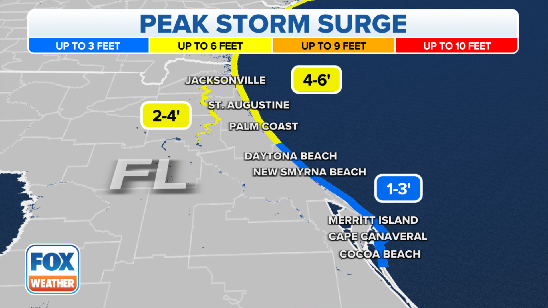
In North Florida, storm surge will be significant as well. People in the Jacksonville should remember Hurricane Irma and the major flooding in and around the St. Johns River and along the coast. And the coastal flood threat will continue north into South Carolina.
This is an unprecedent storm for Southwest Florida. The closest in the history book occurred in 1873 when Fort Myers was a small village. It is critical that people not try to compare it to any previous storm.
Every possible step needs to be taken immediately for personal safety.
FOX Weather Hurricane Specialist Bryan Norcross has a podcast, Tracking the Tropics with Bryan Norcross, available now on FOX News Audio. You can get it on your device by clicking here.