Bryan Norcross: Does potential Tropical Storm Imelda make landfall in the Southeast or turn out to sea?
There is a strong consensus in the various computer forecasts that Imelda will likely track to the north, paralleling the Florida coast at least through the weekend.

Hurricane Specialist Bryan Norcross provides exclusive analysis on future of Invest 94L
FOX Weather Hurricane Specialist Bryan Norcross joins us to give his exclusive analysis on the state of the tropics, including Invest 94L, Hurricane Humberto and possible impacts to the Carolinas.
One year ago this evening, Hurricane Helene flooded the Tampa Bay area and made landfall in the Big Bend Florida devastating communities on the coast. The giant storm, then sped inland creating a swath of destruction across North Georgia before stalling over the mountains of North Carolina and eastern Tennessee. We are thinking about everyone who was affected and is still dealing with Helene’s destruction today… one year later.
The tropics today
The tropical disturbance currently designated Invest 94L is still being disrupted by the mountainous Caribbean islands. But as it lifts north and slowly tracks across or near the Bahamas over the next couple of days, it will likely develop into a tropical depression and eventually Tropical Storm Imelda.
There is a strong consensus in the various computer forecasts that Imelda will likely track to the north, paralleling the Florida coast at least through the weekend. About Monday, however, it looks likely to face a fork in the road. Either it will turn right out to sea, or it will arc left into the Georgia, South Carolina, or North Carolina coast.
The computer models are split on these two possibilities. There are multiple variables in play, but the biggest question seems to be how fast the potential storm moves to the north. It's essentially trying to outrun the influence of Hurricane Humberto, which is intensifying to its east.
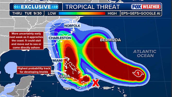
Tropical threat assessment.
(FOX Weather)
A slight difference in track, speed, and intensity looks to decide whether Imelda curves into the Southeast coast or gets pulled out to sea by its big brother Humberto. Humberto’s forward speed will also influence whether they interact or not. Those important slight differences are impossible to forecast before the system has developed, and will probably be an open question for the next couple of days.
Another possibility is that likely-Imelda gets near the coast on Monday or Tuesday and stalls or loops – temporarily affected by Humberto – then a different landfall scenario ensues, perhaps in a different location.
If Imelda does proceed toward the Southeast coast, on the current schedule, it would arrive late Monday or Tuesday. The current thinking is that it could be a Category 1 or 2 hurricane, but obviously everything is subject to change, so stay informed.
The exclusive FOX Weather Tropical Threat analysis shows where Imelda is likely to track, and then how the uncertainty increases as it approaches the Southeast coast early next week.
Flooding impacts
Many of the imaginable outcomes include very heavy rainfall over vulnerable parts of the Southeast, including the Appalachians. Pay close attention to alerts from the local National Weather Service offices, so that you don’t get surprised by flash flooding. Unfortunately, we have a potential for a serious problem in areas that were affected by Hurricane Helene and elsewhere.
Impacts in the Bahamas
The system could develop into a tropical storm over the Bahamas, so be ready for that, especially in the northwestern Bahamas. Otherwise, heavy rain and gusty winds are likely.
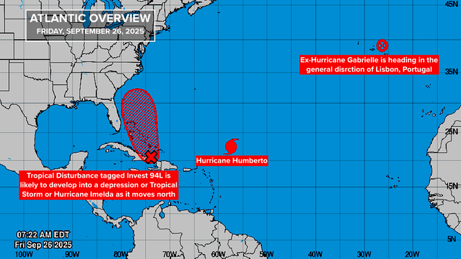
Tropical outlook for the Atlantic as of Sept. 26, 2025.
(FOX Weather)
Southeast Florida
Currently, the likely scenarios show the developing storm passing offshore of the Miami, Fort Lauderdale, Palm Beach metro area. But on Sunday, disruptive weather in the form of bands of heavy rain and gusty winds are possible. Again, it depends on exactly where the storm ends up forming.
The rule of forecasting applies here in spades. Forecasts for just-developing, disorganized, and slow-moving storms are subject to large errors and likely to change. In this case, we could add that storms that are interacting with mountains are especially problematic. Invest 94L/eventual-Imelda has been fighting with the tall mountains in the Dominican Republic, which adds another layer of uncertainty.
Hurricane Humberto
Hurricane Humberto is forecast to continue to intensify. The hostile upper-level winds that were holding it back are universally forecast to continue to ease. The National Hurricane Center is forecasting Humberto to reach Category 4 strength as it arcs between the U.S. East Coast and Bermuda.
The storm is forecast to track west and then north of Bermuda. Its exact track becomes uncertain next week because of potential interaction with Imelda, however. In any case, residents of Bermuda should stay well informed.
BEWARE OF THE 'I' STORM: IT HAS MORE RETIREES THAN ANY LETTER USED FOR ATLANTIC HURRICANE NAMES
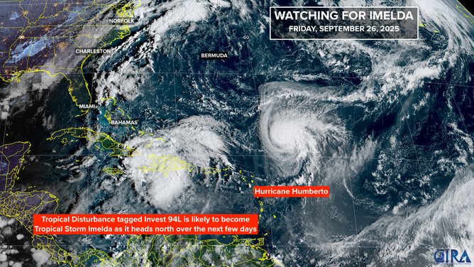
Satellite view of the Atlantic on Sept. 26, 2025.
(FOX Weather)
Ex-Hurricane Gabrielle
Gabrielle is no longer a tropical system, but it's still a formidable storm. It's forecast to take the unusual track near Portugal this weekend as a 40 mph non-tropical system.