Bryan Norcross: Chantal’s remnants to spread north; a note about the Texas tragedy
FOX Weather Hurricane Specialist Bryan Norcross explains Chantal's leftovers will bring rain as far as New England this week. Meanwhile, Norcross remarks on the tragedy unfolding in Texas as moisture from Tropical Storm Barry contributed to the deadly flooding.
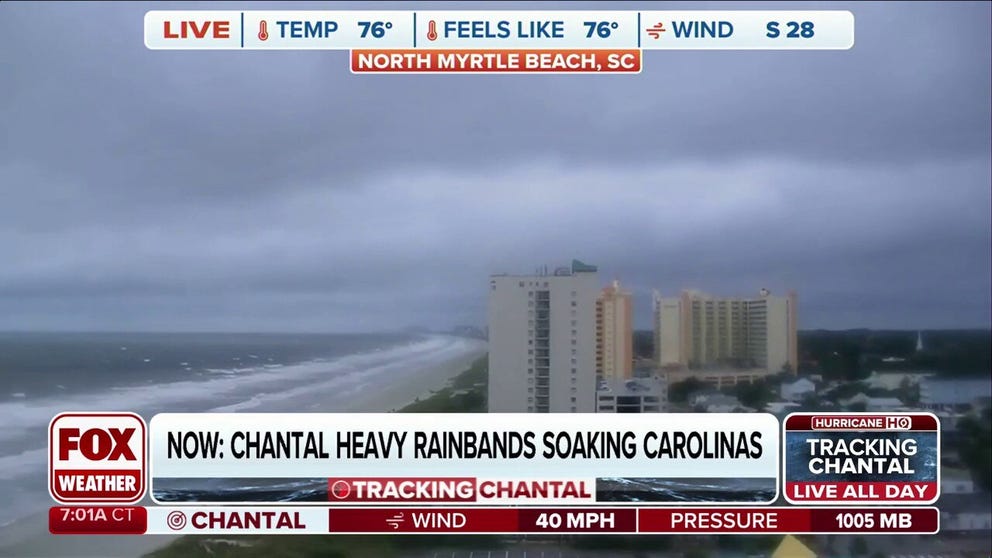
Tropical Storm Chantal begins to weaken after making landfall in South Carolina
Tropical Storm Chantal continues to weaken after the storm made landfall along the South Carolina coast early Sunday morning. FOX Weather Storm Specialist Mike Seidel was in North Myrtle Beach, South Carolina, with the latest on the storm's impacts on July 6, 2025.
Tropical Storm Chantal made landfall Sunday morning just south of Myrtle Beach, South Carolina. Top sustained winds were estimated to be 60 mph – the system perked up just before landfall. Tropical rains have pushed into the Carolinas. The potential for flooding will continue for a couple of days as the remnants of the system slowly pull north.
Fortunately, the soil in eastern North Carolina is relatively dry, and the rivers are on the low side, so there should be less flooding than sometimes occurs with tropical systems. Still, torrential downpours from slow-moving systems always cause localized flooding.
The National Weather Service is forecasting a widespread 2 to 4 inches of rain, with some locations getting 6 inches or more. Be aware of any alerts for your local area if you're in the eastern half of North Carolina or southeastern Virginia.
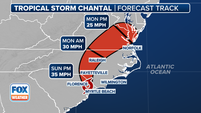
Tropical Chantal cone.
Chantal is forecast to die out in a day or so, but its moisture will be swept north along the coast as far as New England ahead of an approaching cold front. The increase in humidity will be evident Monday and Tuesday from Washington, D.C. to Boston. Tropical downpours can be heavier than you normally experience, so be aware.
Otherwise, there is nothing of concern on the horizon in the Atlantic, the Caribbean, or the Gulf. Looking at 30-year averages, we are well ahead of schedule on named storms, and the first hurricane doesn't develop, on average, until Aug. 11. The season seems slow, but in reality, it is not. Historically, the tropics don't get cranking until August.
How deadly Texas flooding relates to tropical weather
A note about the Texas flooding catastrophe, and how it relates to tropical weather. First, some of the energy and moisture in those extreme downpours came from the remnants of Tropical Storm Barry. But more importantly, the tragedy has similarities to what happened in Hurricane Helene in Western North Carolina.
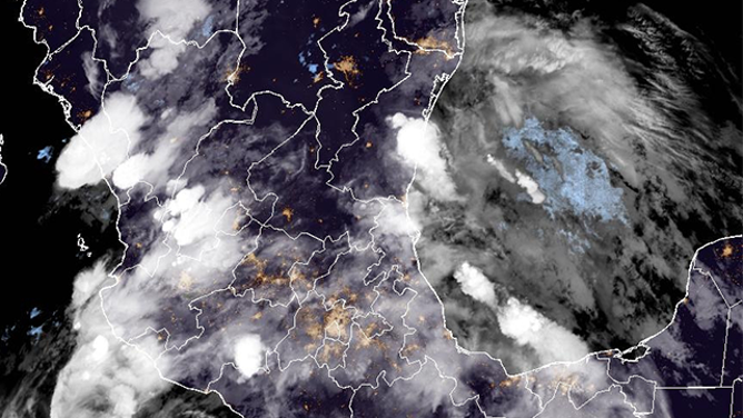
This satellite image shows Tropical Depression Barry on Monday, June 30, 2025.
(NOAA)
In both cases, extreme floods like we’ve seen were imaginable because similar events had occurred in those regions in the past. The geography that can funnel the water into a narrow channel and the proximity to tropical moisture are a dangerous combination. Also, in both cases, timely warnings were issued by the National Weather Service.
The lesson is, if a community or a location has historically been subject to catastrophic flooding, enhanced warning protocols and detailed, short-trigger evacuation plans need to be in place. The same complex of slow-moving thunderstorms occurring over flatlands would cause flooding, but without the deadly consequences. Sirens or other special alerting systems should be considered for locations with a known vulnerability to catastrophic flooding.
History doesn't always teach us what could happen. Sometimes, extreme events occur that have never been seen before, as far as we know. We only have records that go back to the 19th century, but if there's a well-documented disaster in the record book, common sense says we should at least prepare for that.