Bryan Norcross: Watching the Gulf while Atlantic struggles to wake up
The moisture will hang around at least through Saturday. Several inches of rain will fall in some spots along and just inland of the Gulf Coast. Local flooding is possible.

FOX Weather is your Hurricane HQ.
(FOX Weather)
Updated at 8 a.m. ET on Thursday, July 24, 2025
The weak disturbance moving across the northern Gulf is being stretched by hostile upper-level winds. The National Hurricane Center is giving it a slight chance of developing a circulation and becoming a tropical depression.
Computer forecasts indicate that the system’s best chance of organizing might come tomorrow when it’s approaching Texas. For a short time, the upper winds might let up a bit.
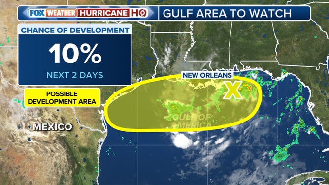
This graphic shows an area to watch for possible tropical development in the Gulf.
(FOX Weather)
Even in the unlikely event the system becomes a depression, however, it wouldn't change the impacts along the coast.
The disturbance is pulling a blob of tropical moisture with it. Bands of strong thunderstorms will continue to push west across coastal sections of Louisiana and the north-central Gulf coast and into Texas tomorrow.
The moisture will hang around at least through Saturday. Several inches of rain will fall in some spots along and just inland of the Gulf Coast. Local flooding is possible.
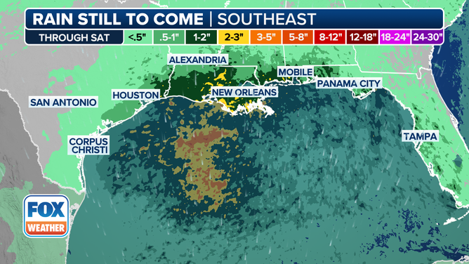
This graphic shows forecast rain totals through Saturday, July 26, 2025.
(FOX Weather)
Don’t look at the specific areas that show heavier rain in the red and orange colors on this map. The point is that some pockets of heavy rain are likely.
This system is moving along at a pretty good clip, so storms aren't expected to linger like they did with the disturbance tagged Invest 93L a couple of weeks ago. Still, with some severe thunderstorms and tropical downpours likely, stay aware of any alerts issued by the National Weather Service along the Gulf Coast.
In the Tropical Atlantic
We're getting conflicting signals from the tropical Atlantic. On one hand, disturbances moving off Africa are increasingly robust. And there is a corridor of very warm water from Africa across to the Caribbean, so the ocean temperature is not an issue.
On the other hand, the Saharan dust is hanging on, and the upper-level pattern is not conducive to systems developing and making their way across the tropical belt. In the Pacific, the water temperature along the equator southeast of Hawaii is edging toward La Niña. If the current trend continues, on average, we would expect the upper-level winds to eventually become more conducive to development across the Caribbean.
Some long-range computer forecasts continue to show a chance of a system developing east of the Caribbean around the beginning of August. But it's a big maybe.
When you add up the pluses and minuses, the minuses look a little bigger at the moment, which they would normally be at this point in July. On average, hurricane season doesn't really ramp up until mid-August, so in some sense, we're looking under the rocks for something to talk about.
Most importantly, there's no sign of anything threatening developing for the rest of the month.