Bryan Norcross: Watching for development over or near Florida
The consensus today is that it will occur off the Southeast coast, but the location has been jumping around. No matter where the low-pressure center might develop, however, stormy weather with heavy rain will cover a wide swath of the region.

FOX Weather is your Hurricane HQ.
(FOX Weather)
Updated at 10 a.m. ET on Tuesday, July 1, 2025
A cold front moving through the mid-South today looks likely to stall and weaken across South Georgia or North Florida late in the week. The various computer forecast models agree that a low-pressure system will form along that old front.
The consensus today is that it will occur off the Southeast coast, but the location has been jumping around. No matter where the low-pressure center might develop, however, stormy weather with heavy rain will cover a wide swath of the region.
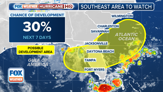
This graphic shows the tropical development chances off the Southeast coast over the next week.
(FOX Weather)
This scenario very often happens in June when fronts from the north meet tropical air from the south. The wind shift across the front along with a leftover upper-level disturbance that pushed the front south in the first place can become triggers for the development of a low-pressure system.
The National Hurricane Center is painting a wide potential development area from the northwestern Gulf across Florida and into the Atlantic due to the uncertainty in where the system will come together, if it does. They are giving the system low odds of developing at this point, but we've seen June storms spin up from old fronts quite often, so attention is warranted.
There is no indication that a strong storm would develop, and most likely periods of heavy rain will be the most noticeable effect, based on what we know now. Steering currents are forecast to be light, so the system and its accompanying rainy pattern look likely to linger through the weekend across much of Florida.
Meanwhile, the tropical Atlantic is closed for business. Hostile conditions continue from Africa to the Caribbean and into the southern Gulf.
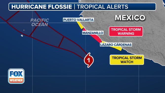
This graphic shows the tropical storm watches and warnings for Hurricane Flossie.
(FOX Weather)
HURRICANE FLOSSIE FORMS IN EASTERN PACIFIC AS MEXICO FACES THREATS OF FLOODING RAIN, MUDSLIDES
In the Pacific, Hurricane Flossie is on a track offshore of the southwestern Mexican coast. Fringe effects will impact land, however, so Tropical Storm Warnings are in effect north and south of Manzanillo. Flossie looks likely to weaken and move out to sea beginning tomorrow.
Former Flossie
A side note: In 1978, Flossie was an Atlantic name. It was cranking in the middle of the ocean on Labor Day that year. Nobody was available at the TV station to do the weather that night because of the Jerry Lewis Telethon that had been on all day. The weather team covered the local part of the event. So I pressed myself into service to handle the evening weather – I was the boss, the news director, at that time. Here’s my first-ever weathercast on WLKY-TV in Louisville, Kentucky. Hurricane Flossie comes up about 1:30 in.