Bryan Norcross: Watching for development of long-haul systems in the tropics
There are areas of interest on both sides of the Atlantic. The development processes are very different, and in both cases, we are going to be watching these systems for a while

Southeastern US could see several areas of tropical activity
FOX Weather Hurricane Specialist Bryan Norcross analyzes an area to watch for tropical development off the southeastern U.S.
There are areas of interest on both sides of the Atlantic. The development processes are very different, and in both cases, we are going to be watching these systems for a while. Meanwhile, Tropical Storm Dexter is heading to its demise in the North Atlantic and is of no consequence.
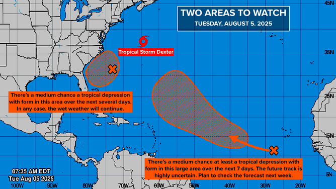
This graphic shows an overview of the tropics in the Atlantic Basin.
(FOX Weather / FOX Weather)
Off the Southeast Coast and Florida
The old front that spawned Dexter is still lodged across South Georgia, North Florida, and the Gulf Coast. The National Hurricane Center is drawing a potential development area off the Southeast coast because another tropical system might organize along the front.
They have bumped the odds of a tropical depression organizing into the medium range, but whether we get an official depression or not, more rain is likely over a large part of the South and especially eastern North Carolina.
The ocean water offshore of the Southeast and Florida is abnormally warm, which will give the system a little boost if it starts to develop.
The computer forecast models predict that a low-pressure center will form along the front well offshore of South Carolina late tomorrow or Thursday. If the forecasts are right, it will migrate toward the North Carolina coast, with the disturbance, whatever shape it's in, tracking north near Cape Hatteras about Saturday.
TROPICAL DEPRESSION COULD FORM OFF SOUTHEAST COAST, CENTRAL ATLANTIC LATER THIS WEEK
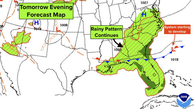
This graphic shows a stalled front over the southeastern U.S.
(FOX Weather / FOX Weather)
At the same time, a disturbance in the mid-levels of the atmosphere laden with tropical moisture is forecast to cross the Bahamas and Florida peninsula.
The end result of all of this is likely to be continued rain for the Southeast spreading into the Mid-Atlantic as the disturbance or depression slowly moves to the north.
In Florida, the moisture will surge later in the week with the mid-level disturbance. Some computer forecasts show that system eventually trying to organize in the Gulf next week. It's something to keep half an eye on. There's no indication of it turning into a strong storm.'
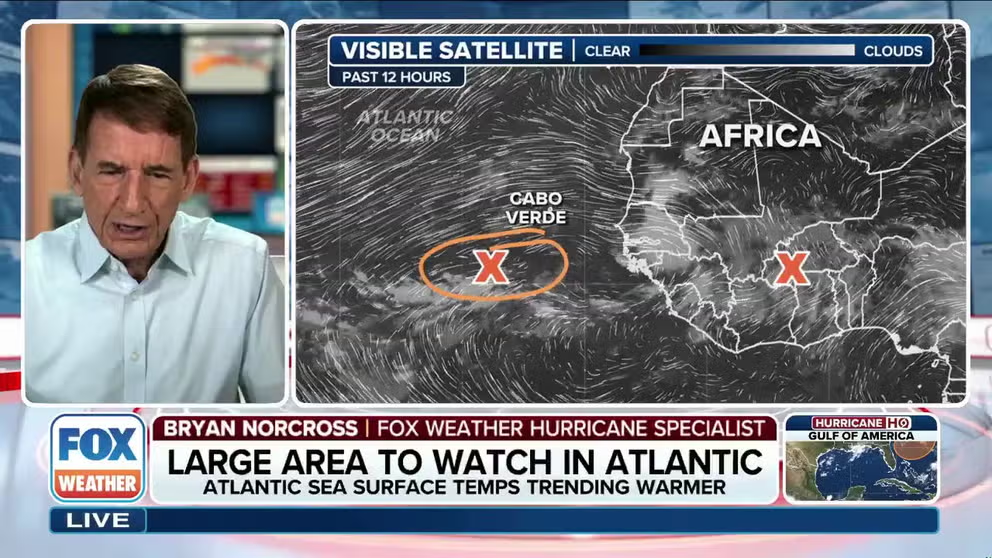
Large degree of uncertainty regarding tropical development of area to watch in Atlantic Main Development Region
FOX Weather Hurricane Specialist Bryan Norcross analyzes the different scenarios regarding the tropical development of systems coming off Africa into the Atlantic Ocean's Main Development Region.
In the Tropical Atlantic and Over Africa
The disorganized tropical disturbance that is triggering the large orange potential development area from the National Hurricane Center is slowly migrating across the tropical Atlantic. For now, it's mostly below the belt of Saharan dust, though dry air does appear to be limiting development.
About Thursday, the consensus of the various computer forecasts is that the system will start to turn north and try to plow through the dust. By Saturday, the consensus breaks down.
The majority of the computer forecasts predict the system will continue north into the middle of the Atlantic and remain on the weak side. It still could become a tropical depression or tropical storm in this scenario—the National Hurricane Center has the odds in the medium range that that will happen.
A blocking high pressure system is often sprawled across the Atlantic. Dips in the jet stream regularly break the high, however, providing a path to the north. These breaks are what commonly cause systems to make an early turn.
In this case, a smaller set of computer forecasts predict that this system will not be strong enough or be positioned to take advantage of the jet stream dip and will continue on a more westerly track becoming a potential threat to land next week. That's not an unreasonable prospect, but we are thinking of it as an outlier at this point.
None of this is going to happen quickly. We'll see how well organized the system gets, how far north or south it develops, and exactly how the weather pattern evolves later this week.
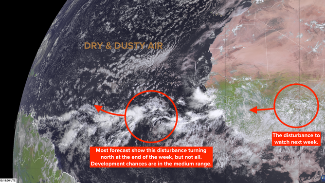
This is satellite imagery of disturbances just off and over Africa.
(FOX Weather)
This first disturbance is on a bit of a knife's edge because it's in the northern part of the tropical belt. Systems there are more likely to turn north. The disturbance that's behind it, which computer forecasts say will move off Africa in a few days, is on a more southern track.
The strong consensus is that the second disturbance will remain fairly weak as it crosses the tropical Atlantic, so it looks to be a system to watch next week and beyond.
The warmest ocean water is in the western part of the tropical basin—the Caribbean, the Gulf, and the Atlantic off Florida and the Southeast. This is where tropical systems will have more energy to work with, if they get that far. So we'll watch systems extra closely that stay on a southern track.