

Bryan Norcross: Remembering 34 years ago today and keeping an eye on Hawaii again
On the current schedule, at least some fringe effects of the system could begin to affect the Big Island on Saturday. Everybody in Hawaii, especially on the Big Island, should stay well-informed.
FILE: Exclusive Analysis: Lala dumps over 3 feet of rain on Hawaii; new disturbances lurk in Pacific
🌀EXCLUSIVE ANALYSIS: FOX Weather Hurricane Specialist Bryan Norcross discusses Lala's unique track and devastating impacts on Hawaii's Big Island. Plus, a new system in the Eastern Pacific that could bring significant moisture to the Southwest U.S. See the exclusive analysis:
Updated at 9:00 a.m. ET on Wednesday, Aug. 19, 2026
Coincidentally, August 19 was a Wednesday in 1992, as it is today. We were tracking the first named storm of the year — a tropical storm northeast of the Caribbean. At first glance, the storm looked impressive on the satellite, but Hurricane Hunters had found it to be disorganized.
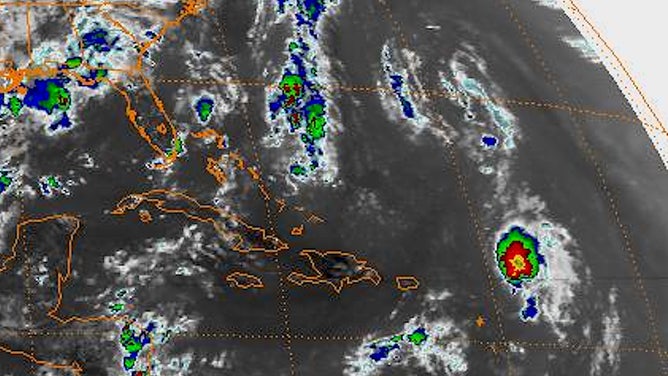
Tropical Storm Andrew satellite from Aug. 19, 1992.
The National Hurricane Center (NHC) was estimating that Tropical Storm Andrew had 50 mph winds that afternoon, down to 45 mph that evening.
Legendary forecaster Hal Gerrish wrote the technical discussion that Wednesday. I highlighted a couple of key points.
LATEST FROM FOX WEATHER HURRICANE SPECIALIST BRYAN NORCROSS
Since there was so much uncertainty, I decided it was a good time to introduce a new graphic I had been working on. It looked a little like a cone, except the weather graphics systems of the time did not have a "filling" function, so the only way to express increasing width with time was to draw dash lines.
I based the length of the arced lines on the average of past NHC forecast errors centered on the current prediction. Notice that 1992 forecasting science produced a spread for the future track of Andrew from south of the Florida Keys to the Carolinas. The goal wasn’t to convey a specific threat, but to present a reasonable range of possibilities.
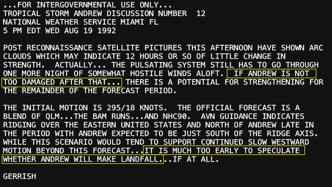
Hal Gerrish discussion
(National Hurricane Center / Hal Gerrish)
In those days, I only used the "cone" when the storm was well offshore. As soon as watches were issued for the coast, I thought they sufficiently conveyed the potential impact zone and the cone became confusing. When the Hurricane Watch was issued for Florida that following Saturday evening, it extended from Titusville in Central Florida all the way to Key West. Such was the uncertainty in the forecasts in those days.
I said on the news that Wednesday evening that if Andrew survived, it could be a threat to South Florida. I gave it about a 50-50 chance, but maybe a little more likely to survive than not. No doubt that thought came from Hal Gerrish's discussion.
BREWING SUPER EL NIÑO EXPECTED TO BE STRONGEST ANYONE ALIVE ON THE PLANET HAS EVER EXPERIENCED
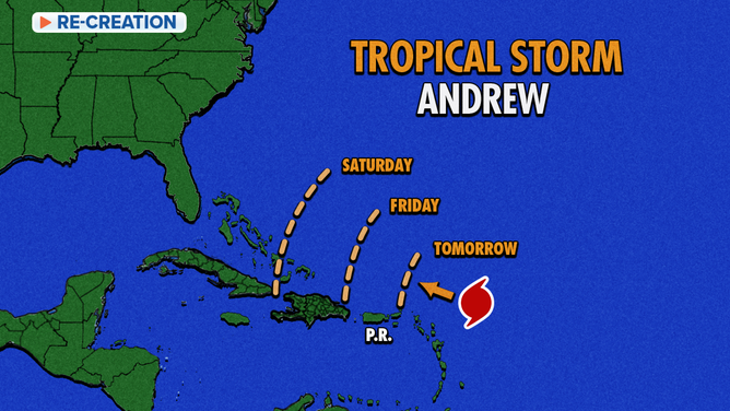
Cone of Tropical Storm Andrew
(FOX Weather)
In 1996, a new graphics system allowed the cone to be filled, and we premiered the ice-cream-cone version that hurricane season. We had to draw the cone by hand, however. It wasn't until 2004 that the graphics machines automatically generated the forecast cone from National Hurricane Center data.
The A storm, Andrew, came unusually late, of course. Although interestingly, it is still the earliest major hurricane on record to hit South Florida.
2026 in the Atlantic
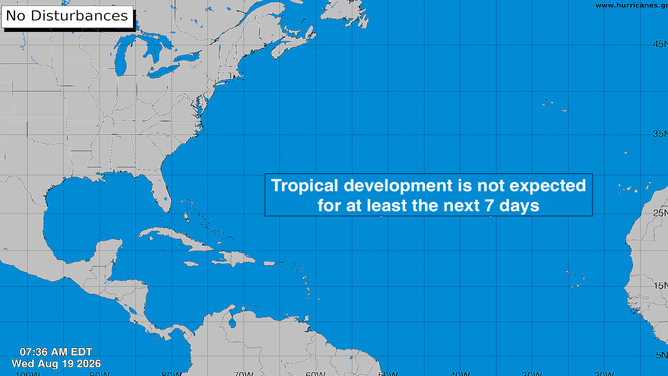
It's basically crickets this week. Disturbances are rolling off Africa on schedule, but the dust, dry air, and El Niño-driven upper winds are preventing them from developing.
Atlantic Basin
(Bryan Norcross)
Long-range computer forecasts continue to show some chance of development toward the end of the month. Although preliminary tracks are into the middle of the ocean. There's no sign of a threat to land in the foreseeable future.
In the Pacific
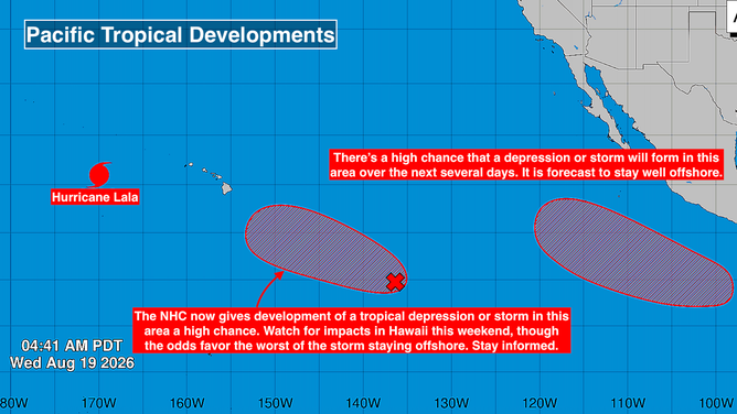
Hurricane Lala continues north into the open ocean. The only threat is to the marine national monument that extends far to the northwest of the main Hawaiian Islands.
The disturbance on the edge of the red area southeast of Hawaii now has a high chance of developing into a tropical depression or tropical storm, according to the NHC. The consensus of the various computer forecasts is that the center of the potential tropical storm or hurricane is most likely to stay south of the Hawaiian Islands, though that's not 100%. We'll have more confidence in the forecasts once the system develops.
LALA ROARS BACK TO HURRICANE STRENGTH, PUTTING MARINE WILDLIFE AND HISTORIC MONUMENT IN ITS PATH
On the current schedule, at least some fringe effects of the system could begin to affect the Big Island on Saturday. Everybody in Hawaii, especially on the Big Island, should stay well-informed.
Pacific Basin
(Bryan Norcross)
The system that's forecast to develop offshore of the Mexican coast in the red potential development area has a high chance of becoming at least a tropical depression, according to the National Hurricane Center. The consensus of the computer forecast models is that it will become a hurricane but stay offshore.
Many of the forecasts turn it toward Hawaii next week, but the early projections show it tracking over cold water, which should cause it to weaken and die out.
These specific systems are mostly triggered by disturbances that rolled off Africa, but couldn't develop in the Atlantic or the Caribbean. The extra-warm Eastern Pacific waters are the fertile ground for development this year.