Bryan Norcross: Hilary impacts Southern California today and new developments in the Atlantic
In the Atlantic, there are five systems to watch. They all could develop, but only two threaten land.
Hilary closes in on California, expected to bring flooding to Southwest
FOX Weather Hurricane Specialist Bryan Norcross explains the impacts from Tropical Storm Hilary to California and the Southwest as the tropical storm closes in on California.
UPDATED Sunday at 11:20 a.m.
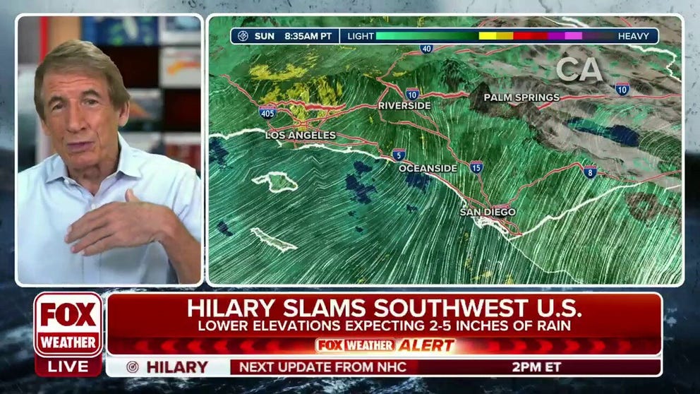
The peak moisture surge from now Tropical Storm Hilary will move into California and the surrounding parts of the desert Southwest today. Significant to catastrophic flooding is predicted as the tropical moisture interacts with the mountain ranges that zig and zag across Southern California and Nevada.
Initially, the biggest push of moisture will be against the eastern slopes of the San Diego mountains that run north up the spine of the state. The heaviest rain will fall at high elevations, then run down into the valleys, washes, and desert arroyos. Flood-control systems, which are normally dry gullies, will likely be overtopped by the rushing water.
The east-west mountains – including the San Gabriel and San Bernardino ranges – north of Los Angeles, Pasadena, and Palm Springs will also catch the moisture in the initial surge.
Beware near creeks, streams, drainage ditches, and low areas, especially in the foothills of the mountains and in desert areas.
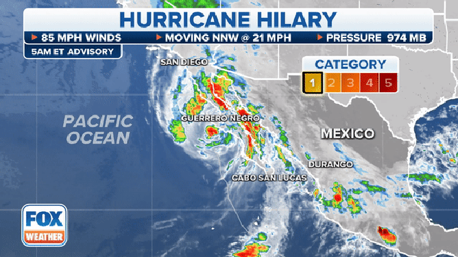
The latest information on Hurricane Hilary on Sunday, August 20, 2023.
(FOX Weather)
Later today, Hilary’s center is forecast to pass over or near San Diego and Los Angeles. After that happens, the winds will switch direction and come in off the ocean. At that point, the moisture feed will impact the west-facing slopes, although it won’t be as strong as the initial surge.
It’s a dangerous day across all of Southern California. Everybody, please stay aware and informed. Not all neighborhoods will be equally affected, but there is a threat of life-threatening mudslides, rockslides, or washed-out roads across the region.
The peak impacts will move from south to north through the second half of today and through tonight. Better weather will overspread the area tomorrow.
In the Atlantic, there are five systems to watch. They all could develop, but only two threaten land.
Tropical Disturbance #3 crossed South Florida and will move rapidly across the Gulf of Mexico over the next couple of days. The National Hurricane Center is still giving it a medium chance of acquiring a circulation and developing into at least a tropical depression before it comes ashore in Texas late Monday or Tuesday. It will be accompanied by some gusty winds, but it will also come with highly beneficial rain.
The Tropical Disturbance near the southeastern Caribbean islands – officially named Invest #90L because the National Hurricane Center is "investigating" it – will turn north over the next couple of days and bring heavy rain and gusty winds to the northern Caribbean. The National Hurricane Center predicts it will likely develop into a tropical depression.
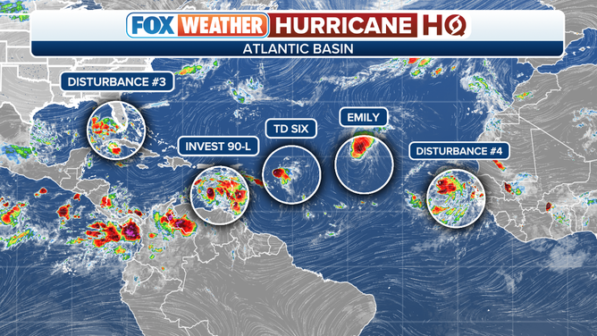
Atlantic tropical overview of Tropical Storm Emily, Tropical Depression 6 and three other disturbances.
It’s not likely to strengthen into something super strong, but impacts are possible over the mountainous islands from the extended period of high levels of tropical moisture and gusty winds.
Adding to the situation, Tropical Depression 6 developed to the east of the northeastern Caribbean islands. It’s forecast to die out soon because of dry air and hostile upper winds, but moisture might extend the rainy streak on Puerto Rico and the surrounding islands.
Stay aware of the alerts that will likely be issued for the potential of flash flooding over the next several days.
Closer to Africa, Tropical Storm Emily developed, but it should be short-lived and will die in the open ocean.
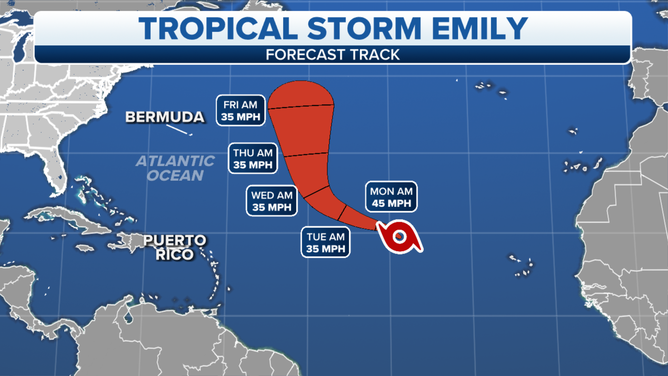
Tropical Storm Emily cone.
(FOX Weather)
There is another system just off the coast of Africa with a good chance of eventually getting named, but it doesn’t look like a threat to land at this time.
All a good reminder that, on average, the peak of the hurricane season begins today.