

Bryan Norcross: Last day of nor'easter as the Atlantic minimally stirs, Polo to bring flooding to Southwest
FOX Weather Hurricane Specialist Bryan Norcross breaks down the fading nor'easter, Atlantic basin with minimal activity and a busy Pacific basin full of tropical activity.
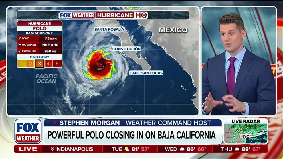
Tropical Storm Rachel forms behind Hurricane Polo, targeting Mexico
🌀 BACK TO BACK: As the FOX Forecast Center monitors Hurricane Polo inching closer to Mexico and the Southwest U.S., a new threat, Tropical Storm Rachel, follows close behind this week's severe weather.
Updated at 12 p.m. on Monday, Sept. 28, 2026.
NOR'EASTER FADES
The system that was the mighty nor'easter has fully merged with an upper-level low-pressure system. It's now a weak version of its former self, but it's still going to spread gusty winds and rain from Long Island, New York, through New England.
The storm's moisture will move out of the Northeast later today and clear New England tomorrow.
NOR'EASTER TO BRING FINAL DAY OF RAIN TO MILLIONS AS COMMUNITIES ASSESS FLOOD AND BEACH DAMAGE
Warm weather returns to the East Coast by midweek as the leftovers of the Midwest heat dome shift east behind the nor'easter.
IN THE ATLANTIC
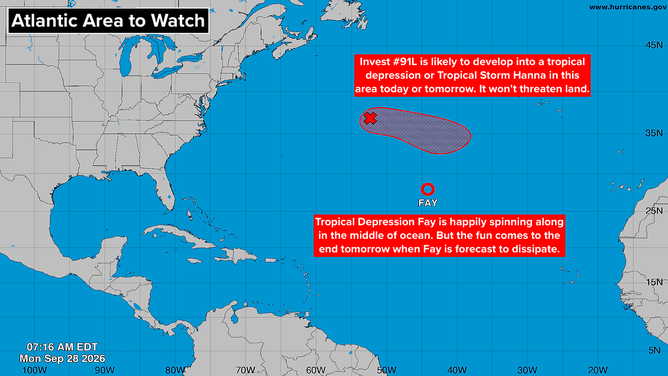
Tropical activity in the Atlantic basin.
(Bryan Norcross / FOX Weather)
Tropical Depression Fay is still chugging along but going nowhere. It will die out in a day or two in the middle of the Atlantic.
To Fay's north is another small disturbance. The National Hurricane Center gives it a high chance of becoming a depression or Tropical Storm Hanna. In any case, it won't be a threat to land.
HURRICANE POLO AND THE U.S. FLOOD THREAT
Hurricane Polo will make landfall today in Baja California Sur, the southern part of the Baja California Peninsula. Later the storm will cross the Gulf of California and make a second landfall in the state of Sonora, Mexico. People in the hurricane warning zones should be ready for a strong Category 2 or perhaps a Category 3 storm, which means that full hurricane preparations are required.
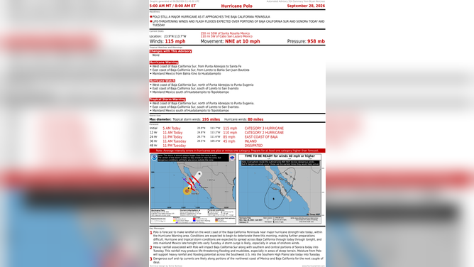
Hurricane Polo churns in the Pacific and is expected to make landfall in Mexico on Monday night.
(FOX Weather)
Moisture from Polo plus perhaps a contribution from former Pacific Hurricane Odalys will meet an upper-level disturbance moving in from the Pacific over the desert Southwest. There is a significant flood threat in parts of Arizona, New Mexico, and southeastern Colorado. Rain is likely over a good part of those states.
This is especially threatening over the parts of New Mexico that have already been inundated by the excessive monsoon rains this month.
CALIFORNIA DECLARES STATE OF EMERGENCY AS POTENTIALLY HISTORIC SUPER EL NIÑO LOOMS
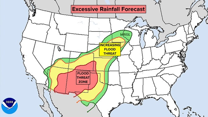
Tropical moisture in the Southwest this week.
(Bryan Norcross)
Tomorrow, the disturbance will tap into Gulf moisture, and an approaching cold front will exacerbate the situation. A low-pressure system is likely to form east of the Rockies causing widespread heavy rain and potentially severe weather in the middle of the country. Stay aware of local alerts this week.
HURRICANE POLO EXPLODES INTO ONE OF PACIFIC’S STRONGEST HURRICANES EVER
ELSEWHERE IN THE PACIFIC
Tropical Storm Rachel has formed offshore of southern Mexico. It is forecast to track northwest offshore of the Mexican coast, more or less following Polo. Hurricane Polo stirred up some cool water, however, so that may limit how strong Rachel can get.
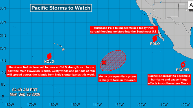
Tropical activity in the Pacific basin.
(Bryan Norcross)
In any case, Rachel will likely have some effect on the coastal sections – a Tropical Storm Watch is in effect for part of the southwestern Mexico coast. Plan to stay informed this week in southwestern Mexico.
Hurricane Nolo is forecast to reach Category 5 strength south of Hawaii. If this happens, it will be the first time that four Category 5 hurricanes have formed in the Central and Eastern Pacific in the same season. The extreme El Niño plus the broad marine heat wave from Hawaii to California to the equator are responsible, of course.
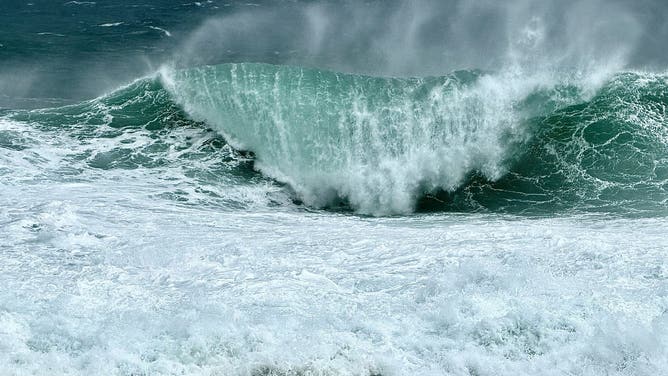
Massive swells generated by Hurricane Nolo as seen from South Point, Hawaii, on Sep. 27, 2026.
(FOX Weather Senior Correspondent Robert Ray / FOX Weather)
The main Hawaiian Islands will feel some gusty winds and periods of rain as the storm heads toward the open Pacific today and tomorrow.
Another tropical depression or storm is likely to form between Hawaii and Mexico. The current projections show that it won't be of any consequence.
WHAT'S THE DIFFERENCE BETWEEN A HURRICANE MAKING A DIRECT HIT AND LANDFALL?
Hurricane Polo, former Hurricane Odalys, and eventual likely Hurricane Rachel will put significant energy into the Pacific Ocean, which will impact the beaches from northern Orange County to Ventura County in Southern California.
Dangerous surf conditions are expected today and tomorrow, then again when Rachel's energy reaches SoCal. Stay aware of the latest alerts.