Bryan Norcross: Don forms in the Atlantic; What does it mean for the rest of hurricane season?
This fifth named storm of 2023 comes more than a month before the average date.

Generic Hurricane HQ
(FOX Weather)
UPDATED Friday at 9 a.m.
The system in the central Atlantic finally organized sufficiently to be named Subtropical Storm Don overnight. The satellite shows a well-developed circulation but with the tall thunderstorm clouds far removed from the center. This is one of the characteristics of a subtropical storm, which is a hybrid of a tropical storm and a nor’easter.
Don is forecast to move north and flirt with very chilly ocean water before drifting back south. So it’s likely to weaken but might restrengthen again next week. In any case, it’s no threat to land.
This fifth named storm of 2023 (remember, we had a phantom unnamed storm in January in the North Atlantic that counts) comes more than a month before the average date.
So the obvious question is, what does all this early activity mean for the rest of hurricane season?
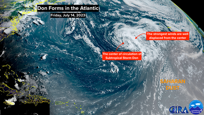
Subtropical storm Don seen on satellite image.
(NOAA)
That January system and Don developed out of non-tropical systems that happened to sit over warm enough water just long enough to develop. They fit in that "subtropical" bucket. There is nothing unusual about that process.
Tropical Storm Arlene, the short-lived system that drifted through the Gulf, was likely boosted by the very warm water temperatures this year. But the system itself was generated by a non-tropical process and might have spun up anyway. So it was only loosely related to this season’s exceptional water temperatures.
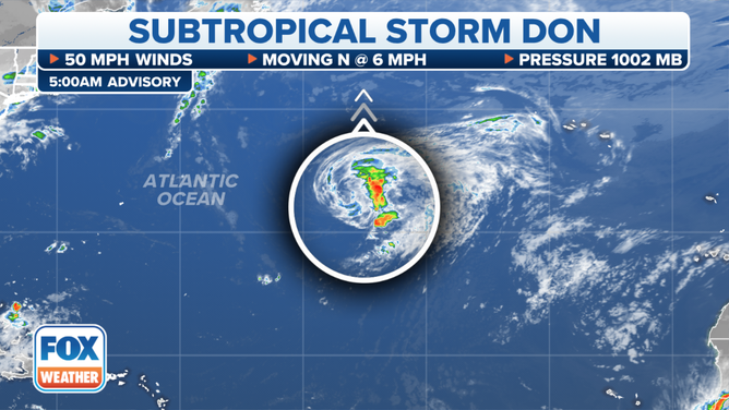
Latest position on Subtropical Storm Don
(FOX Weather)
Bret and Cindy formed in the tropical Atlantic east of the Caribbean islands, and they were 2023 freaks. Never had two storms formed in that key part of the ocean in June, and rarely does even one storm develop there early in the season.
A bubble of unusually conducive atmosphere over the exceptionally warm ocean water was enough to kick them off. Now the atmosphere over the tropical Atlantic has returned to normal with dust and hostile upper winds dominating, and storm development is squashed.
The takeaway is that the fact that we have had five storms already doesn’t say much. But the two June storms in the tropical Atlantic remind us that there is a lot of extra hurricane fuel out there for later this season when the atmosphere will become conducive for development.
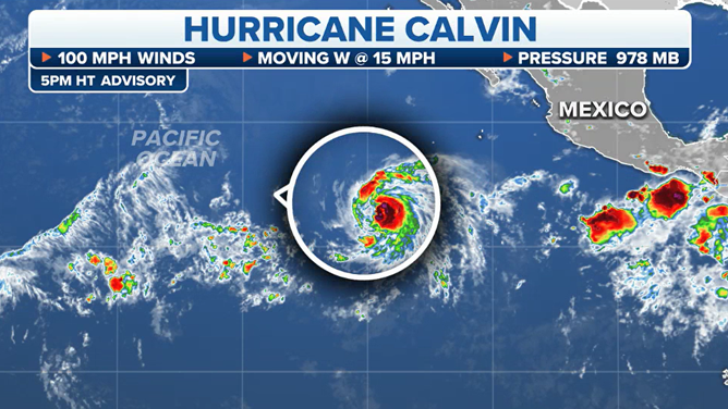
Tracking Hurricane Calvin
(FOX Weather)
Logic tells us that a given storm will be more likely to become a hurricane by drawing extra energy from the warm ocean. But for now, the tropics are expected to remain quiet for the next week at least.
In the Pacific, Hurricane Calvin has strengthened and is forecast to reach Category 3 strength today before a weakening process kicks in. The system is heading in the general direction of Hawaii. By the time the system tracks near the Big Island, however, it is forecast to drastically weaken.
The effects on the islands will likely be limited to a moderate moisture surge, especially on the windward side of the mountains, gusty winds, and high surf. But residents in the eastern Hawaiian Islands should monitor Calvin’s advisories to be sure nothing changes.