Bryan Norcross: Watching the disturbance 97L in the Caribbean for Central America impacts later this week
The National Hurricane Center gives Invest 97L a medium chance of developing into at least a tropical depression before the center reaches Central America on Friday or Saturday.

FOX Weather is your Hurricane HQ, streaming free 24/7.
(FOX Weather)
Updated Wednesday at 9:15 a.m. EDT
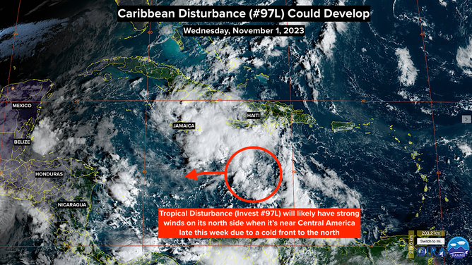
The tropical disturbance officially labeled Invest 97L is a disorganized mass of cloudiness. It appears to be trying to develop a circulation center south of Haiti. Large complexes of thunderstorms are north and east of the disturbance but don't appear to be related to the circulation.
Upper-level winds are blowing the tops off the thunderstorms, which is a sign that the atmospheric environment is at least somewhat hostile to the system developing. Computer forecasts indicate that the upper-level pattern will become moderately conducive over the western Caribbean over the next couple of days, which could give the disturbance a chance to organize.
The National Hurricane Center gives the system a medium chance of developing into at least a tropical depression before the center reaches Central America on Friday or Saturday.
NOAA satellite image of Invest 97L.
(NOAA)
A complication in the weather pattern is a strong cold front pushing through Florida today. A combination of the high pressure behind the front and the low pressure from the disturbance will create strong winds on the north side of the circulation, even if it never organizes very much. Likely, those winds will be over 40 mph, which increases the chance of the system being named Tropical Storm Vince.
To be designated a tropical depression or a tropical storm, the system has to have a sufficiently organized circulation center. But even a broad disturbance can help create strong winds when air is pushed south by high pressure behind a front.
The brisk northeast wind from the front will be noticeable from Mexico's Yucatán Peninsula through Belize to Honduras later today. On the current schedule, the disturbance, or whatever form it takes, should reach Nicaragua or Costa Rica on Friday or Saturday.
Many long-range computer forecasts indicate that general low pressure will linger over or near Central America, which is a common weather pattern this time of year. Heavy rain over the mountainous area is possible.
As long as the cold fronts keep coming, tropical systems will be suppressed to the south. But we'll keep an eye on the broad Central American low. Sometimes, it's a spawning ground for disturbances that find a path north.