Bryan Norcross: Coastal storm to impact East Coast Friday through weekend; new system to watch in Atlantic
By Friday, the low will drift north and intensify in the nearshore waters of the Carolinas or Georgia, generating gusty onshore winds well to its north and bands of heavy rain. There is some chance the system could extract enough heat from the ocean to separate itself from its parent front and become a subtropical storm.

FOX Weather is your Hurricane HQ, streaming free 24/7.
(FOX Weather / FOX Weather)
Updated at 9 a.m. EDT on Wednesday
An area of low pressure will start to form tomorrow out of the front stalled across south-central Florida and its associated strong thunderstorms. A disturbance in the upper atmosphere will move in from the west and interact with the front to produce an atmospheric environment conducive for more thunderstorm development over and near the Florida Peninsula, as well as the organization of a low-pressure system connected to the front.
By Friday, the low will drift north and intensify in the nearshore waters of the Carolinas or Georgia, generating gusty onshore winds well to its north and bands of heavy rain. Since the low will be drifting over the warm Gulf Stream waters, there is some chance the system could extract enough heat from the ocean to separate itself from its parent front and become a subtropical storm – a hybrid between a tropical system and a nor’easter.
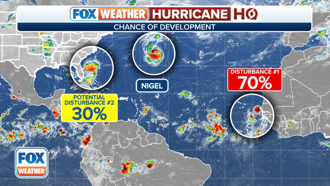
An overview of the tropical Atlantic Ocean on Wednesday, September 20, 2023.
(FOX Weather)
The time window is short, so the National Hurricane Center gives this process a low chance of happening, but developments can happen quickly over deep, warm waters. The Gulf Stream is one of the most energetic pools of heat content that support tropical development.
Whether the system becomes Subtropical Storm Ophelia or not, nasty, windy and wet weather will likely spread from the Southeast into the mid-Atlantic and New England Friday into the weekend.
Watch for local alerts concerning coastal hazards due to strong onshore winds and heavy rainfall inland.
While nasty weather looks likely north of the storm, the circulation around the system should push the first cold front of the season down the Florida Peninsula for a refreshing period of somewhat-lower-humidity air for Friday and Saturday in South Florida.
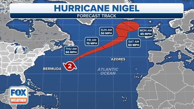
The forecast track for Hurricane Nigel.
In the Atlantic well offshore of Bermuda, Hurricane Nigel is likely at peak strength as a Category 2 hurricane. It’s rounding the bend in its track to the north and will eventually get absorbed into a large North Atlantic low-pressure system. The only threat from Nigel will be some enhanced energy in the surf from the U.S. East Coast to the Caribbean.
A new tropical disturbance has moved off the coast of Africa. The National Hurricane Center is giving it a high chance of developing into at least a tropical depression. A number of the various computer forecasts indicate it could become Tropical Storm Ophelia or Philippe, depending on what happens with the system near the U.S. East Coast.
The consensus of the computer forecasts is that the system will be in the general vicinity of the northeastern Caribbean islands in about a week. Until the disturbance becomes better developed, forecasts are likely to jump around from well north of the islands to a closer call. We’ll have to keep an eye on it until its future path is clearer.