Bryan Norcross: Caribbean disturbance could develop next week
The system is forecast to stew more or less in place for the next several days with no significant organization. About the middle of next week, however, a dip in the jet stream is forecast to traverse the Gulf of Mexico.

FOX Weather is your Hurricane HQ, streaming free 24/7.
(FOX Weather)
Updated Saturday at 9 a.m. EST
A cluster of clouds and thunderstorms in the extreme southern Caribbean is part of a larger disturbance that straddles Panama into the Pacific. The system is forecast to stew more or less in place for the next several days with no significant organization.
About the middle of next week, however, a dip in the jet stream is forecast to traverse the Gulf of Mexico. Two things can happen related to this type of weather pattern. Ahead of the dip, a bubble of atmosphere, which is generally conducive for tropical development, is likely to move over the southern Caribbean. It appears there will be a time next week when the disturbance will have an opportunity to consolidate into at least a tropical depression.
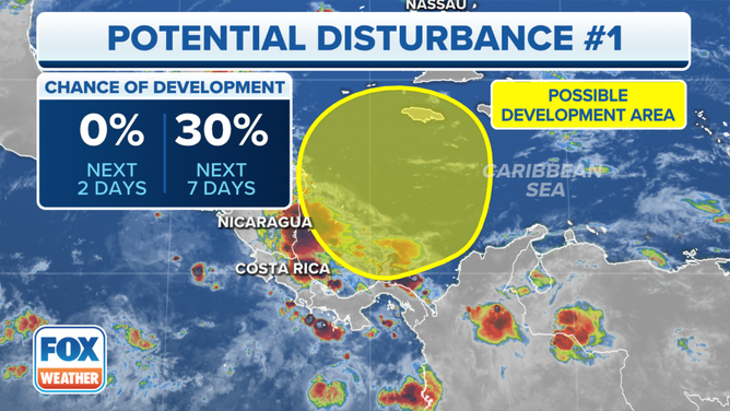
The outlook for a potential disturbance in the southwestern Caribbean Sea.
(FOX Weather)
The second effect of the jet-stream dip could be to scoop up the potential depression or perhaps Tropical Storm Vince and pull it to the north. Eastern Cuba, Haiti, the Dominican Republic and the southeastern Bahamas could be affected.
If the disturbance stays broad and ill-defined, as many long-range computer forecasts indicate, it would more likely remain in the Caribbean. If it can organize and develop tall thunderstorms, it appears more likely to track toward the islands late next week.
The National Hurricane Center gives the system a low chance of consolidating into a tropical depression over the next seven days.
The long-range computer forecasts are giving us a mixed message. The American GFS model has been insisting that an organized system will pull north toward the islands. But the other credible computer models mostly show the disturbance simply meandering in the Caribbean.
The GFS has been known to over-develop southern Caribbean disturbances, but the scenario it presents is not impossible.
For now, folks in the northern Caribbean islands should keep an eye on developments. Cold fronts and strong jet-stream winds should keep anything that develops away from the U.S.