Bryan Norcross: Calvin knocking on door of Big Island of Hawaii while Don limps and Florida boils
The excess heat near Florida will only affect hurricanes if one happens to track in the direction of the state later in the season. Everybody in the hurricane zone needs a plan of action if that happens.

Generic Hurricane HQ
(FOX Weather)
Updated Monday at 9:30 a.m. EDT
In the Pacific, Calvin is now a tropical storm and weakening, but the system is forecast to track near the Big Island of Hawaii late tomorrow. Watches and warnings are coming. On the current schedule, a weakening Calvin will pass near the Big Island and south of the main Hawaiian Islands on Wednesday.
The main effects are likely to be on the windward-facing sides of the mountains. Very gusty winds that could cause power outages, local flooding and high surf are all possible. Everybody in Hawaii should stay informed of the latest forecasts from the Central Pacific Hurricane Center in Honolulu and instructions from local authorities.
The latest predictions are for top winds at the coast to be in the 40- to 50-mph range, but much higher gusts are likely at higher elevations.
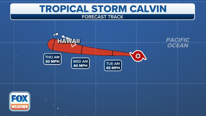
The forecast cone for Calvin in the Central Pacific.
(FOX Weather)
In the central Atlantic, Don still has a healthy spin but only a few thunderstorm cells, so it’s been downgraded to a subtropical depression. Over the next few days, the system is forecast to loop in place. When it moves far enough south and is again traversing warmer waters, it could restrengthen. It looks like it would become Tropical Storm Don.
The distinction between a subtropical system and a purely tropical system has to do with the distribution of the thunderstorms and strongest winds around the center, which are related to the atmospheric mechanism that powers the storm.
In any case, Don is not a threat to land.
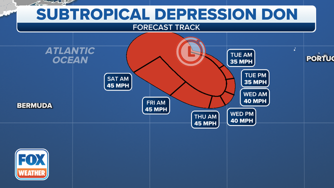
The forecast cone for Don in the central Atlantic.
(FOX Weather)
Elsewhere in the Atlantic, Saharan dust stretches all the way across the ocean to the vicinity of Florida. The dust dries the mid-levels of the atmosphere, which prevents the tropical disturbances coming off Africa from strengthening. There’s no sign the dust will let up through this week, at least.
The extremely uncomfortable summer weather in South Florida will continue for a while. The ocean breeze has been limited by the unusual strength and orientation of the Bermuda High over the Atlantic. Light winds have allowed the waters through the Bahamas and around Florida to heat up to record levels. When the breeze blows off exceptionally warm water, it contains more humidity and has less cooling effect than normal.
The combination of heat and humidity caused the National Weather Service to issue an Excessive Heat Warning for Miami for the first time ever.
The excess heat near Florida will only affect hurricanes if one happens to track in the direction of the state later in the season. Everybody in the hurricane zone needs a plan of action if that happens.