Bryan Norcross: Calvin impacting Hawaii while there's a new disturbance to watch in the Atlantic
Tropical Storm Calvin will bring gusty winds to 50 or 60 mph in some locations on the windward side of the Big Island, heavy rain with the possibility of isolated flash flooding and extremely high surf.

FOX Weather is your Hurricane HQ, streaming free 24/7.
(FOX Weather)
UPDATED at 9 a.m. ET Wednesday
The center of Tropical Storm Calvin is passing south of the Big Island of Hawaii, but the storm's effects extend far to the north. Gusty winds and tropical downpours are moving across the eastern end of the Hawaiian Island chain.
Calvin's intensity jumped late yesterday to 60 mph, but the storm is in its weakening phase now. That trend is expected to continue as hostile upper winds increasingly impact the circulation through the day today. The system should be past the islands late today Hawaii Time, and then die out in the open Pacific Ocean.
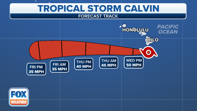
Tropical Storm Calvin cone.
(FOX Weather)
The official track of the storm is the path the center of circulation takes. Since the center's closest approach will be about 85 miles south of the southern tip of the Big Island, Calvin won't have made official landfall in Hawaii. But the tropical storm-force winds extend about 140 miles to the north, and the rain bands have spread well north of that – far enough that most of the main Hawaiian Islands will feel the peripheral effects of Calvin.
Gusty winds to 50 or 60 mph in some locations on the windward side of the Big Island, heavy rain with the possibility of isolated flash flooding, and extremely high surf are the threats today as Calvin passes by. A typical trade-wind regime will return tomorrow over the islands.
In the Atlantic, the National Hurricane Center is noting a tropical disturbance near Africa that has a slight chance of developing as it tracks into the central tropical Atlantic in a few days. The disturbance is plenty robust, but the atmosphere up ahead is very dry, and Saharan dust looks to be an obstacle to the system's development. It's not out of the question, however, that a sufficient gap in the dust comes along to allow thunderstorms to form around a circulation.
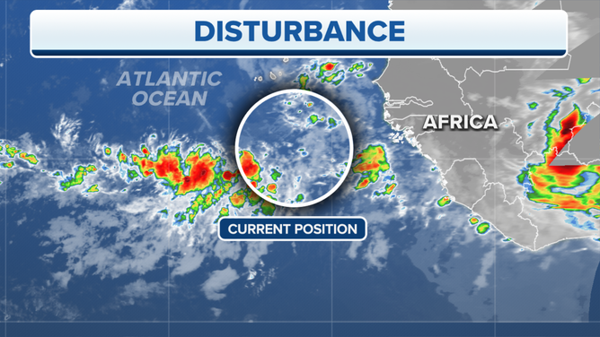
The National Hurricane Center is monitoring a tropical wave in the Atlantic for possible development.
(FOX Weather)
A blocking high-pressure system seems well entrenched to the north, so the system, in whatever form, should head briskly west in the direction of the Caribbean. On the current schedule, it would arrive in the vicinity of the eastern Caribbean islands early next week.
Farther north, Tropical Storm Don is finishing its giant loop in the open Atlantic. The storm is finding some warmer ocean water, so it's forecast to intensify a bit before dying out in the cold North Atlantic. Don is not expected to have any significant effect on land.